3 days of Backpacking, Thunderstorms & Hammock Camping in Heavy Rain on a section of Pennsylvania’s Black Forest Trail.
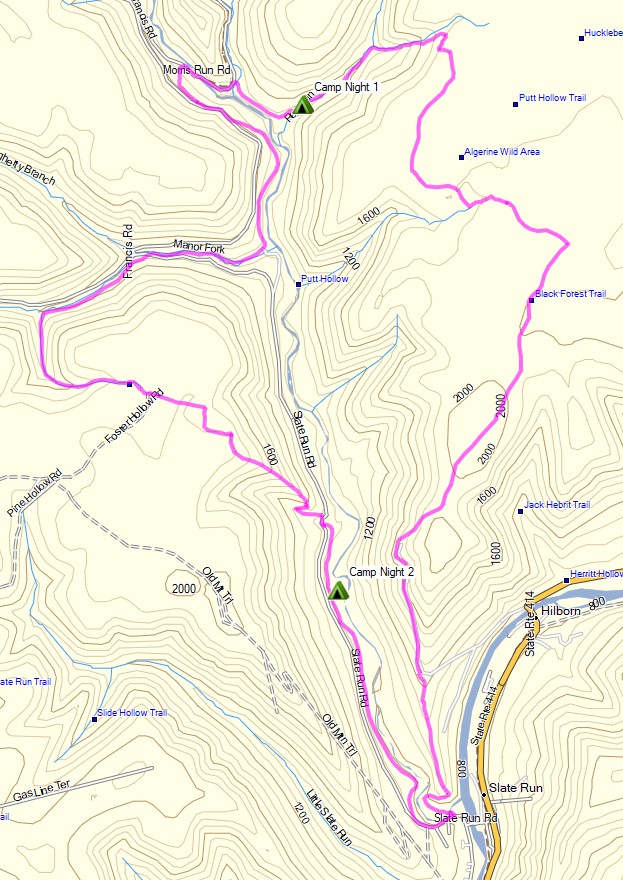
For this adventure, I headed out for a 3 day, 2 night solo backpacking trip in Pennsylvania’s Tiadaghton State Forest. The full Black Forest Trail is a rugged 43 mile loop with 8,550′ of elevation gain that I’ve done in the past and really enjoyed.
Facing a July forecast in the triple digits with thunderstorms, and the fact that my last solo hike was a pretty intense one, I decided to scale the mileage back this time. My general plan was to simply go into the woods and use the network of connector trails to come up with a route on the fly, based on how the weather played out from day to day.
Black Forest Trail Short Loop – Route Overview – Sintax77
Hammock Camping and Solo Backpacking in the White Mountains of New Hampshire
FTC Disclosure: This post contains affiliate links, which means I may receive a commission for purchases made through some of my links.
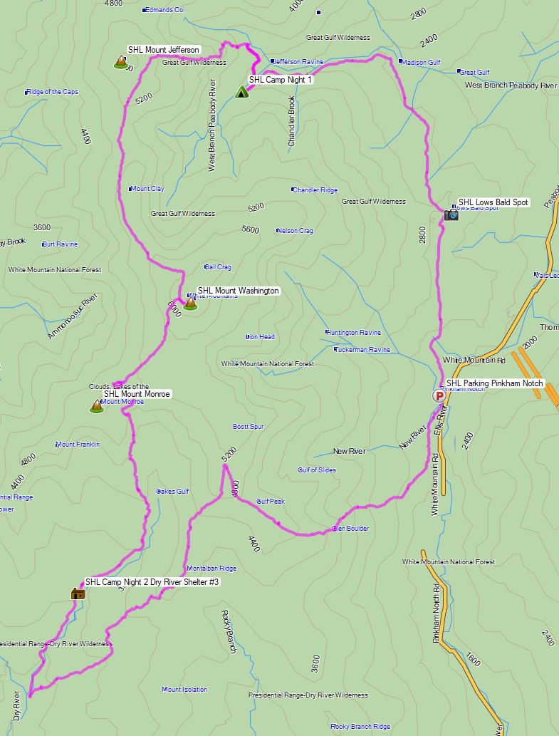
For this adventure, I decided to get back to my ultralight backpacking roots with a rugged 27 mile loop through the Great Gulf Wilderness, Dry River Wilderness, and Presidential Range, with a gross elevation gain of around 8,400 feet. The centerpiece of my loop would be the Six Husbands Trail, a trail that some say is the most difficult in the White Mountain National Forest. Now , if you’re familiar with the WMNF, you probably know that just about every trail is pretty intense, so this could get interesting…
For sleep and shelter, I went with my standard minimalist hammock camping setup consisting of a 10 oz hammock, 5 oz tarp, and a pair of 40° down quilts. This got my base weight down to around 7 lbs. A full gear list can be found at the bottom of this post.
The Six Husbands Trail was Built from 1909 to 1910 by trail builder Warren W. Hart of the Appalachian Mountain club. Hart was known to build his trails specifically with adventure in mind, and this trail was no exception. It begins deep in the Great Gulf Wilderness at the junction with Wamsutta Trail, which along with the connected Alpine Garden trail is actually just the renamed southern portion of the Six Husbands trail. Wamsutta was one the six husbands of female Indian Chief, Weetamoo, who has a nearby waterfall named after her.
White Mountains Six Husbands Backpacking Loop – Route Overview – Sintax77
3 days of Hammock Camping & Solo Ultralight Backpacking in Virginia’s George Washington National Forest.
FTC Disclosure: This post contains affiliate links, which means I may receive a commission for purchases made through some of my links.
For this backpacking trip, I headed down to the border of Virginia and West Virginia for some early spring camping to get a dose of some warmer weather, babbling brooks, and mountain views.
With the milder temps and decent forecast, I was able to get my base weight down to 7.75 pounds, a welcome change after hauling some pretty heavy loads my previous few backpacking trips.
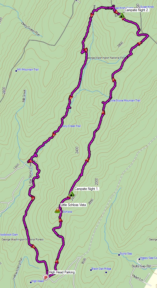
For sleep and shelter, I went with my minimalist hammock camping setup consisting of a 10 oz hammock, 5 oz tarp, and a pair 40° down quilts. The 14 mile Little Schloss Loop has a decent amount of unofficial, but preestablished campsites with some nice open areas and decently spaced trees, making it a great loop for hammocks. You can find my full backpacking gear list for this trip at the end of this post.
Water is plentiful on the Little Stony Creek side of the loop, but the ridge side of the loop that I started with is dry for the first 5 miles, so I packed in a full load of water for my first day. Finding water every couple of miles on the remaining two days was no problem at all.
Route Overview – Little Schloss Backpacking Loop – Sintax77
FTC Disclosure: This post contains affiliate links, which means I may receive a commission for purchases made through some of my links.
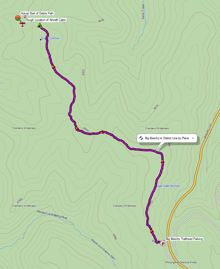
For this backpacking trip, we hiked into the Cranberry Wilderness in search of a twin engine private plane that crashed in 1995 and went missing for 6 years, deep in the forests of a remote West Virginia mountaintop. There was also a hiker who went missing here back in 2011.
For sleep and shelter, Frank and I both decided to pack in our Amok Draumr Hammock camping systems. This would allow us to get a comfortable camping setup even if we were forced to camp in one of the mossy rock fields that are often encountered along mountain ridges in the Cranberry Wilderness. A detailed gear list can be found at the bottom of this post.
On the morning of November 28th, 1995, a Cessna 414, tail number N28901 took off from Braxton County Airport in Sutton, West Virginia headed for Lynchburg Regional, Virginia. After encountering low visibility due to foggy conditions, the lone pilot contacted air traffic control to request an IFR (instrument flight rules) flight plan in order to continue navigating the approaching mountainous terrain. After a period of apparent poor communications, possibly due to a radio issue, ATC lost contact with the pilot. Transponder signals ceased not long after the last communication, and the plane was never heard from or seen again until it was spotted from the air over six years later.
3 Days of Backpacking, Hiking & Hammock Camping on the Appalachian Trail in Virginia.
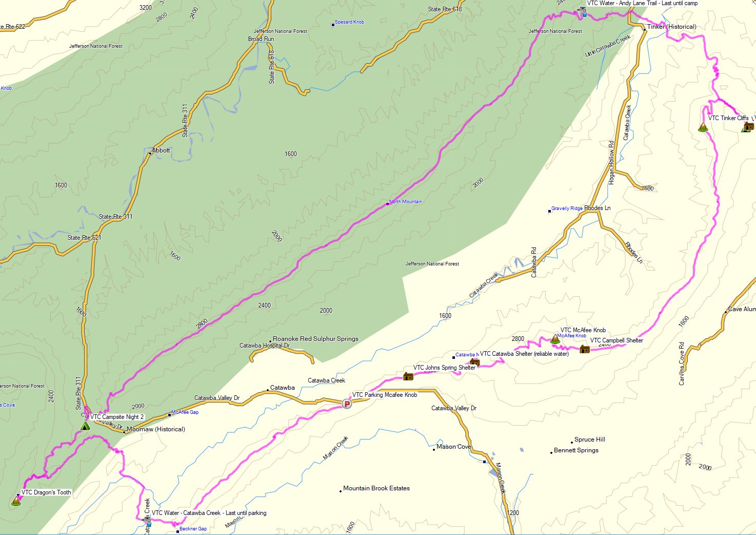
For this late summer backpacking trip I’ll be hiking the Virginia Triple Crown, which consists of three iconic Virginia hiking destinations – McAfee Knob, Tinker Cliffs, and Dragon’s Tooth.
To create the loop, I essentially took an Appalachian Trail section hike and combined it with the North Mountain trail to close it off into a 35 mile backpacking loop. This gave me a healthy southern mix of mountain hiking, open pastures, and sweeping summit views.
I went with my most basic warm weather ultralight backpacking gear list for this trip, just to keep things simple and light. Due to the threat of rain, I also included a full set of rain gear. Surprisingly how I was still able to keep my base weight down to around 7.5 lbs. This was mostly achieved by simply leaving non critical items at home. Notable items are below or you can see my full gear list with weights & gear links on LighterPack here.
While on the AT in this area, you may only camp at one of the four designated shelters. Since I was exclusively on the AT for the entire first day, this gave me the following camping options:
Jonh’s Spring Shelter
Catawba Shelter (reliable water)
Campbell Shelter
Lambert’s Meadow Shelter (reliable water)
I chose to camp near Lambert’s Meadow Shelter, as it was the farthest one into the loop and offered reliable water.
3 days of Hammock Camping in the Rain and Solo Ultralight Backpacking in the Linville Gorge Wilderness.
For this backpacking trip, I headed down to North Carolina’s Pisgah National Forest for some hammock camping along the Linville River. The particular section of river I chose was surrounded by the Linville Gorge, the upper ridges of which stand an average of 1,400 feet above the river banks below. This terrain, combined with a dense network of unofficial trails without signage or switchbacks, and often uncrossable river, can make for some rather challenging and exciting hiking. Add in a forecast of fog and hiking in the rain, and you’ve got yourself a recipe for some true southern outdoors adventure.
Despite the rain, my mid-June temp range for this trip was relatively warm at 70° – 48° or so. This allowed me to get my backpack’s base weight down to around 9 lbs by leaving my puffy jacket, base layers, warmer hat, gloves etc at home. I simply packed a long sleeve shirt and a buff and used my rain gear for supplemental warmth at camp.
I went with a fairly minimalist hammock camping setup for this trip. There are plenty of trees and fun unofficial campsite gems to be found in the Gorge that make ideal for hammocks. Water is obviously of minimal concern for the lower regions of the gorge. This allows you to save some weight on trails in those sections, but make sure to stock up when your route heads up towards the ridge. Especially if you’re looking to camp in one the beautiful ridge side campsites up there. The extra planning and water weight is well worth the views.
A free permit is required on weekends and holidays from May 1st through October 31st each year. You can find more information on the NFS Grandfather Ranger District website here.
If planning your own trip, I would highly recommend visiting LinvilleGorge.net for maps, info and extensive GPS data including official and unofficial trails, campsites, water sources, etc. Due to the nature of my trip and the fact that their data is so darn good, I didn’t package my own GPS file for this trip,but I did make an overlay map image from their track data that can be downloaded here. Just unzip it and copy the image file to your Garmin’s /Garmin folder if you’re using a Garmin GPS like me, or follow whatever instructions pertain to your particular GPS device.