3 Days of Winter Camping, Backpacking & Campfire Cooking in Pennsylvania’s Pinchot State Forest.
FTC Disclosure: This post contains affiliate links, which means I may receive a commission for purchases made through some of my links.
For this late winter backpacking trip, I decided to challenge myself to cook “real food” using only fire for the duration of my trip. If you know anything about my patience for making fires, you’ll know this will truly be a bit of a challenge. 🙂
For shelter, I went with my minimalist camping hammock and ultralight backpacking tarp set-up. I also utilized a grill grate, a folding saw for harvesting campfire wood, and some extra cold weather clothing layers, as the temps were forecasted to head down to around 15° F or so. There was also a chance of snow, sleet, and even rain, so I brought a full set of rain gear for warmth at camp and keeping dry while hiking.
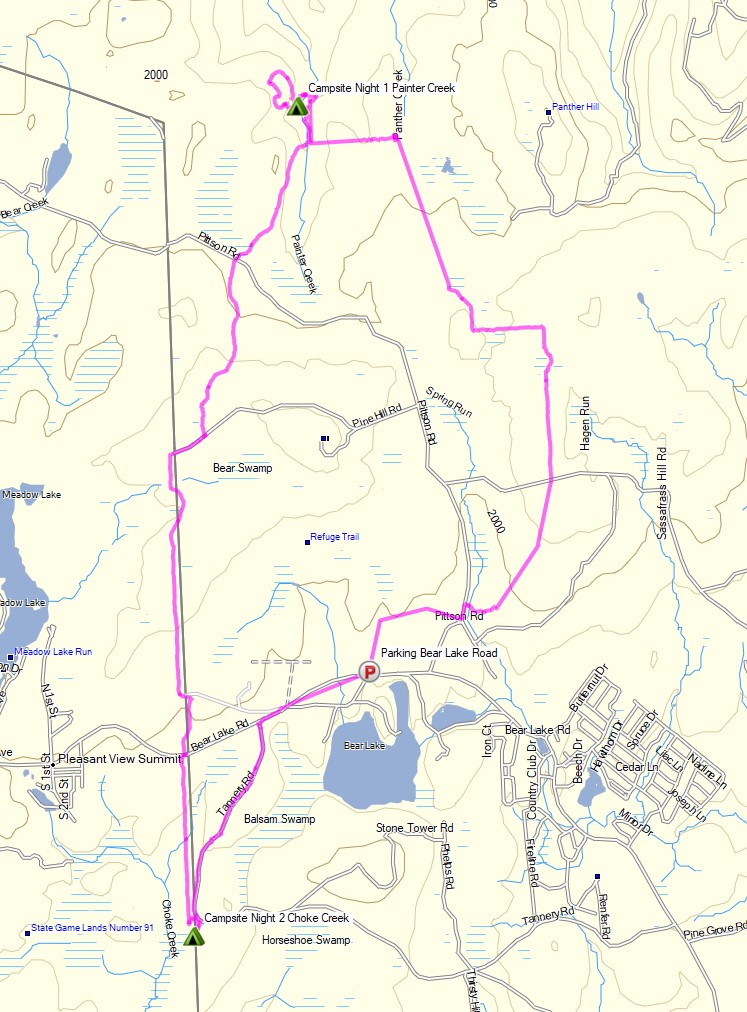
Full Route Overview – Pinchot Trail North Backpacking Loop – Sintax77
3 Days of Winter Hammock Camping and Backpacking in the Roaring Plains Wilderness during Snow and Freezing Rain.
FTC Disclosure: This post contains affiliate links, which means I may receive a commission for purchases made through some of my links.
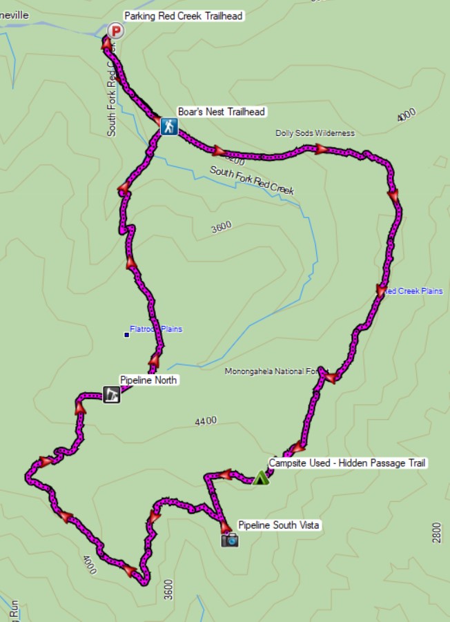
For this late winter backpacking trip, I decided to head back down to West Virginia’s Monongahela National forest to do some ridge hiking and cold weather hammock camping. Due to temperatures forecasted from the low 20’s to the low 40’s, I needed to pack in some heavier warm clothing layers for this trip, along with some camp tools, so I used my larger winter backpack. For sleep and shelter, I used my go-to ultralight hammock and tarp set-up with winter grade down quilts (full gear list below). As it turns out, I probably should have used that extra pack space for a larger tarp too, but live and learn I guess…
The 6,792 acre Roaring Plains West Wilderness is a remote federal wilderness area located about 3 miles south of the more popular Dolly Sods Wilderness Area. It boasts a healthy network of trails, which are unmarked and often, grown in and hard to follow. Official paper maps are hard to come by, and by some accounts, not very up to date. Based on my personal experience, I would highly recommend using a GPS with appropriate data while hiking here. You can also find good trail info and map print-outs at MidAtlanticHikes.com and HikingUpward.com. I also recorded my personal GPS data for this trip, which can be found here.
Backpacking & Winter Camping on the side of Mount Washington.
FTC Disclosure: This post contains affiliate links, which means I may receive a commission for purchases made through some of my links.
For this adventure, I headed back up to the White Mountains of New Hampshire to do some snow camping and make another attempt at doing a Mt Washington winter ascent for some frozen views of the Presidential Range. I tried this about a year ago, but a stomach bug and 85 MPH winds kind of put a damper on things. This time around, I also brought a hiking partner, Frank. We’ve done several winter trips together so far, but this would be his first time in the White Mountains.
Similar to last year’s trip, the plan was to set up a base camp at higher elevation, followed by a lighter weight trek up to the top of Mount Washington if weather conditions and visibility were agreeable. If the conditions were questionable, we made a back-up plan to scurry up the side of the nearer Mt Monroe. And of course, if the weather really got bad, we would just play it safe and stay below tree line.
Trailhead Used: Ammonoosuc Ravine Trailhead
44°16’01.2″N 71°21’40.7″W
Base Station Rd, Jefferson, NH 03538
This is a large parking lot with room for many vehicles. A parking fee of $5 dollars per day or an annual National Park pass is required.
Trails Used
Ammonoosuc Ravine Trail
Appalachian Trail (Crawford Path)
Mt Monroe Loop Trail
Campsite
Camp along Ammonoosuc Trail 44.26398, -71.32182
This was a small unofficial campsite located in a hollowed out spot not too far before entering the Lakes of the Clouds Forest Protection Zone.
Backpacking, Hiking & Winter Tent Camping with Snow in Pennsylvania’s Hammersley Wild Area.
FTC Disclosure: This post contains affiliate links, which means I may receive a commission for purchases made through some of my links.
For this early December backpacking trip, I set out to hike a 3 day, 20ish mile loop in the mountains of north central Pennsylvania. I created my loop by using a portion of the Susquehannock Trail System, some off-trail bushwhacking, and a ridge hike along the adjacent Twin Sisters Trail.
My weather conditions were forecasted to have some fresh snow, temps mostly in the 20’s and a potential for freezing rain as the temps rose further into the trip. While this was a pretty wide range of possible conditions, it also wasn’t terribly cold, so I was still able to pack somewhat ultralight and minimal. My camping target for day one was down in the hollow along the banks of Hammersley Fork. On day two I planned to head up to the ridge and camp in the area devoid of trees due to a forest fire back in 1962. Due to the potential lack of trees, I swapped out my typical hammock setup for a single person tent and sleeping pad to keep my campsite options flexible.
The Hammersley Wild Area is the most remote swath of public land in Pennsylvania, with some spots over 5 miles from the nearest road, which combined with the season, I hoped would make for some rather secluded camping. Conversely, this area is also a haven for public hunting, so I made sure to wear some blaze orange and remain somewhat quiet and on the trail until I got further away from any road access, as it was the middle of PA deer hunting season.
This trip video was sponsored by Dr Prepare. You can get 10% off their 178Wh Portable Power Station by using code STDP10 with this link.
Backpacking, Hiking & Shelter Camping in Vermont’s Lye Brook Wilderness.
FTC Disclosure: This post contains affiliate links, which means I may receive a commission for purchases made through some of my links.
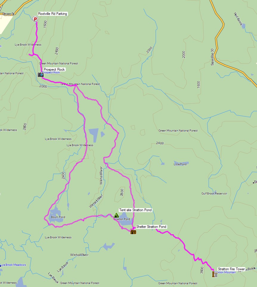
For this late November backpacking trip, I decided to hike a 3 day, 23 mile loop in the Green Mountains with 2 nights of camping near Stratton Pond and Bourn Pond. By setting up a base camp at Stratton Pond, I would also have the opportunity to do an out and back hike on the second day to visit the fire tower that sits atop Stratton Mountain. Built in 1934, the 360 degree views from this fire tower are said to have inspired the creators of the Appalachian Trail and Vermont Long Trail, the latter of which runs the entire length of Vermont.
My weather conditions were forecasted to range from above freezing down into the upper 20’s with a mix of rain, sleet, and snow throughout the trip. Because of this, I added some additional clothing layers, gloves, and a full set of rain gear to my standard ultralight backpacking load-out. My sleep system was a minimalist hammock camping setup, so I was still able to keep my pack’s base weight down to around 10 pounds.
This particular area of the Lye Brook Wilderness offers a wide variety of backcountry camping options including unofficial (but legal) stealth camping, designated tent sites, and a very nice 3 level wooden shelter. I decided to keep my options open see how things played out based on the weather and what mood I was in once I got there.
Winter Camping in a Snow Storm on North Fork Mountain, West Virginia.
FTC Disclosure: This post contains affiliate links, which means I may receive a commission for purchases made through some of my links.
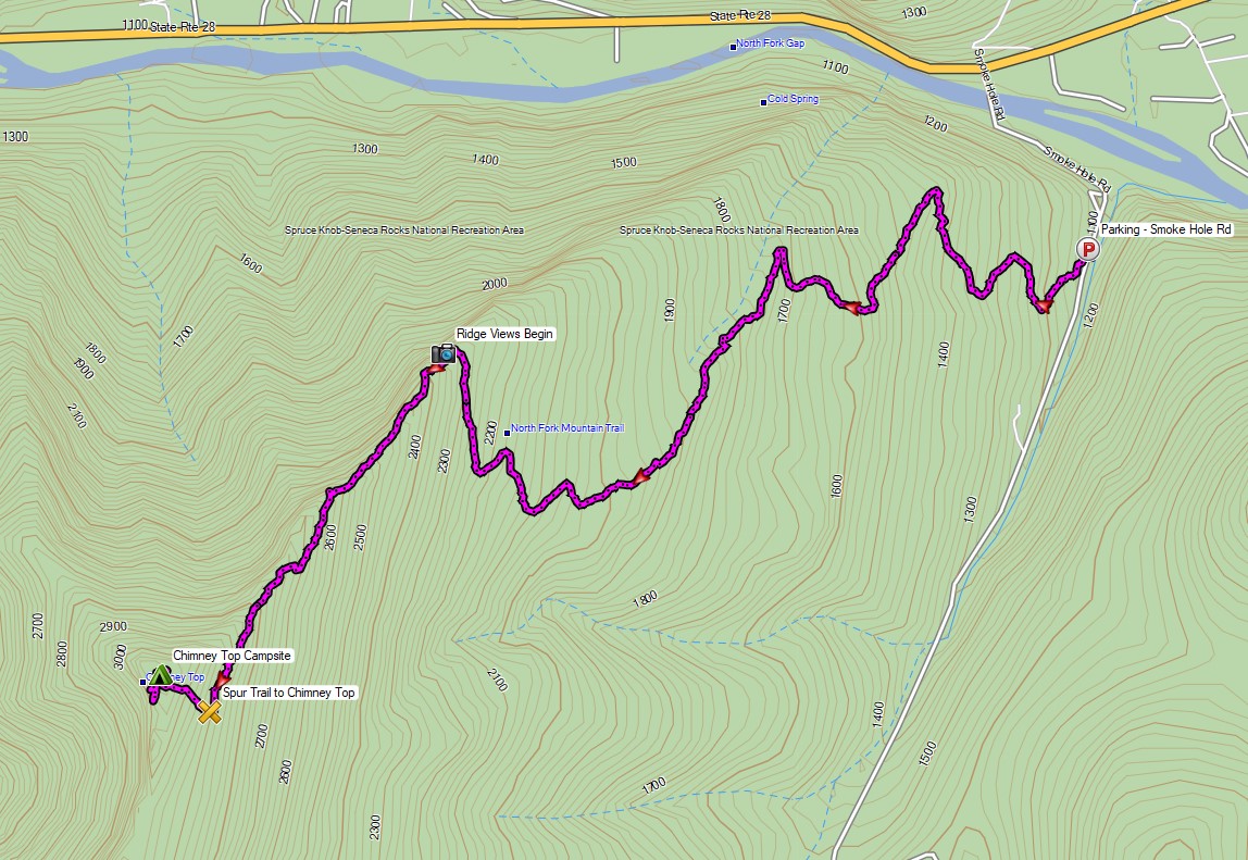
For this winter backpacking trip, we set out to do some overnight camping in the Monongahela National Forest by an awesome vista known as Chimney Top during the last week of January. The weather forecast showed the potential for a snow storm to land some time between the first night and the morning of the next day, so we decided to keep our mileage fairly low and laid back. Temperatures were projected to be fairly steady in the low to mid 20’s Fahrenheit.
Our initial climb up to the ridge would require a gross elevation gain of roughly 2,000 feet over the course of two miles. Once we got to the ridge, we would be afforded with seemingly endless mountain views overlooking the Potomac River, New Creek Mountain, and Dolly Sods in the distance. After following the ridge for a while we would start to look for campsite opportunities.
Besides the quick elevation gain, our main challenge on this trip would be water. There is only one semi reliable water source on the entire 25 mile length of the North Fork Trail, and it’s located right around the half way point at 12.5 miles. We wouldn’t be going that far, so we would have to pack in all of our water for drinking and cooking. If the snow storm had hit prior to our arrival, we would have had the advantage of melting snow. With the ground dry and free of snow upon our arrival, we decided to pack in 1 gallon (4 liters) of water per person.
For shelter, Frank and James went with tent camping in individual tents, while I chose to go with a hammock camping setup. With this mix of shelters, we hoped to be able to find a decent spot to camp on the ridge with some nice mountain views.
Route Overview – North Fork Mountain Trail Chimney Top – Sintax77
No permit is required to backcountry camp in the Monongahela National Forest.