Hiking the Dix Range Pt 1 – Adirondacks 3 Day Backpacking Trip | Hammock Camping

Join Sara and I for 3 days of Hiking & Hammock Camping on a Backpacking Trip in the Adirondack’s Dix Mountain Wilderness.

For this backpacking adventure, I’ll be breaking the hiking trip into two parts. Part 1 covers our hike in to camp, setting up our base camp with our two person hammock camping system, and some campfire chat while we make a campfire, do camp chores, and cook some backpacking food.

Hiking the Dix Range Part 2 will be comprised of mostly hiking and summits, as we ascend from camp up onto the Dix Range to hit the Beckhorn (a subsidiary peak of Dix Mountain) and the summit of Dix Mountain itself.

GPS Data for this trip is available on the Trip Data Page or by clicking this link for direct download: Adirondacks Dix Range Backpacking Trip 2017 – Sintax77

Trailhead and Parking Location

Elk Lake Trailhead Parking Lot, 675 Elk Lake Rd, North Hudson, NY 12855
44°01’15.0″N 73°49’40.9″W

Topics discussed and things that happen in this episode

  • Base camping with a ton of camping gear vs ultralight backpacking.
  • Finding & legal camping spots in the Adirondacks.
  • Pros and cons of using a bear canister. These are not legally required in the Dix Mountain Wilderness, but we had one anyway, for reasons discussed in the video.
  • Hammock camping with our dog, Denali.
  • Outfitting our Dutchware Chameleon Hammocks with the Double Dutch Bugnet system.
  • Hammock under quilt attachment using of Chameleon hammock’s underquilt hooks.
  • A look at the MalloMe Camping Cookware Set for backpacking food preparation.
  • Building a campfire and cooking some of of favorite backpacking appetizers and dinners.
  • Sara reviews a flashlight…

Trails Used Day 1

  • Parked at Elk Lake Trailhead Parking Lot.  This is a decent sized lot along a gravel road on the way to the Elk Lake Lodge.  If the lot is full, you may park for free at the Elk Lake Lodge, a bit further up the road.
  • Elk Lake to Dix Mountain Trail
  • Pass the Slide Brook Lean-to . The Slide Brook LT and camping area makes for a popular base camp for hikers hitting the Dix Range. We chose to push on a bit (under 2 miles) to the lesser used Lillian Brook lean-to area, which as some nice, legal campsites that are a bit more secluded.
  • Pass the sign for Lillian Brook LT and continue a bit further.
  • Setup camp along the Elk Lake Trail, after the Lillian Brook LT and just before the large bridge crossing Lillian Brook.  As of 9/14/17, this site had a yellow “Camp Here” disc, designating it a fully legal spot, despite it’s proximity to a small stream nearby. The stream is probably a convenient water source when flowing good, but we opted to get our water a 100 meters or so down the trail by the Lilian Brook bridge.

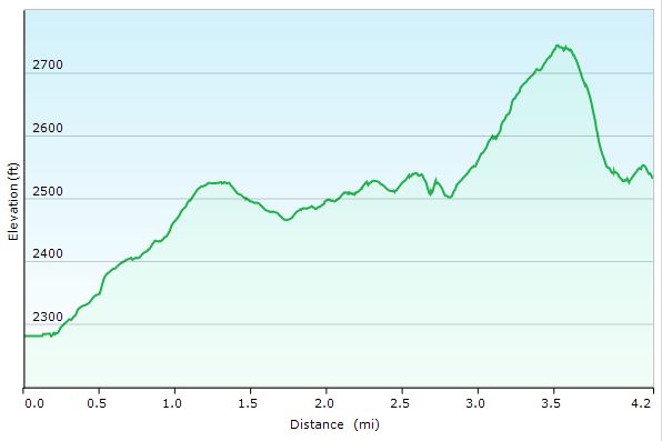
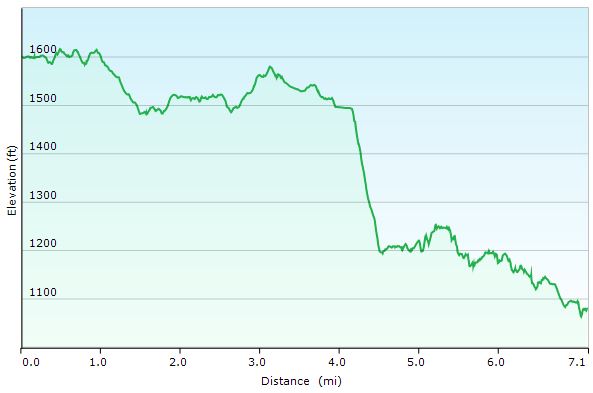
Dix Range Adirondacks Day 1 Elevation Profile – Sintax77

Day 1 Total Mileage:  4 miles
Day 1 Gross Elevation Gain: 633 feet
Day 1 Gross Elevation Loss:  339 feet

Notable Camping / Backpacking Gear Seen on this Video

Our Dog’s Backpacking Gear

Backpacking Food

Stay tuned for Hiking the Dix Range Part Two where we depart camp and head for ridge.

Hiking Big South Fork Pt 2 – Tennessee Hammock Camping & Backpacking Trip

Join me for 3 days of hiking & hammock camping on a backpacking trip in Tennessee’s Big South Fork Nat’l Rec Area.

For this backpacking adventure, I’ll be breaking the hiking trip into two parts. BSF Part 1 is mostly in the woods and at camp and is more of a hanging in the woods, conversational type video. Part 2 covers days 2 and 3 where I traverse into the higher regions of Big South Fork, hitting the ridges for views of the Cumberland Plateau’s sandstone bluffs and Big South Fork River.

For more details on the first day of this trip, check out my Big South Fork Pt 1 blog post and video.

GPS Data for this trip is available on the Trip Data Page, or via this link for direct download: Big South Fork Backpacking Loop 2017 GPS Data – Sintax77

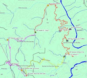
Big South Fork John Muir John Litton Backpacking Loop Route Overview – Sintax77

Trailhead and Parking Location

Bandy Creek Visitor Center, 151 Stable Rd, Oneida, TN 37841
N36° 29.275′ W84° 41.837′

Topics discussed and things that happen in this episode

  • Place Holder

Trails Used Day 2

  • Break camp along the Laurel Fork Creek Trail
  • Continue north on the Laurel Creek Fork Trail
  • Make a left (east) onto the John Muir Trail (the next 2 miles will cover the bulk of the elevation gain for the day)
  • Make a right (west) onto the Fall Branch Trail
  • Setup camp along the Laurel Fork Creek Trail (less than a 100 meters after crossing the creek / bridge.  There is a campsite immediately next to the creek as well)

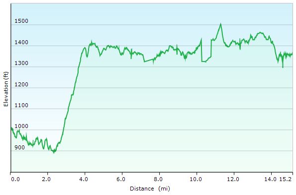
Day 2 Total Mileage: 15.2 miles
Day 2 Gross Elevation Gain: 1,616 feet
Day 2 Gross Elevation Loss: 1,266 feet

Big South Fork Day 2 Elevation Profile – Sintax77

Trails Used Day 3

  • Break camp along Fall Branch Trail
  • Continue south on the Fall Branch Trail
  • Make a Right (north) onto the John Litton Farm Hike Loop Trail (heading south will ultimately bring you back to the parking lot as well).
  • Continue south onto the road (gravel, then paved) until you arrive back at the Bandy Creek Visitor Center Parking Lot.

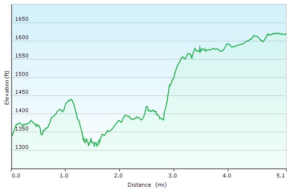
Day 3 Total Mileage: 6.1 miles
Day 3 Gross Elevation Gain: 600 feet
Day 3 Gross Elevation Loss: 313 feet

Big South Fork Day 3 Elevation Profile – Sintax77

Trip Grand Totals

Total Mileage for Trip: 28.4 miles
Total Elevation Gain for Trip: 3,076 feet

The gear list used for this trip along with discussion on each item can be found in my accompanying 2017 Ultralight Backpacking Gear List Blog Post and Video.

Hiking Big South Fork Pt 1 – Tennessee Hammock Camping & Backpacking Trip

Join me for 3 days of hiking & hammock camping on a backpacking trip in Tennessee’s Big South Fork Nat’l Rec Area.

For this backpacking adventure, I’ll be breaking the hiking trip into two parts. Part 1 is mostly in the woods and at camp and is more of a hanging in the woods, conversational type video. In BSF Part 2 we will traverse into the higher regions of Big South Fork, hitting the ridges for views of the Cumberland Plateau’s sandstone bluffs and Big South Fork River.

GPS Data for this trip is available on the Trip Data Page or by clicking this link for direct download: Big South Fork Backpacking Loop 2017 GPS Data – Sintax77

Trailhead and Parking Location

Bandy Creek Visitor Center, 151 Stable Rd, Oneida, TN 37841
N36° 29.275′ W84° 41.837′

Topics discussed and things that happen in this episode

  • Feeling like a lost idiot on the trail.
  • Camp setup priorities when arriving at camp.
  • Setup / breaking camp in the rain.
  • Continuous Ridgeline usage and setup for quick and easy tarp deployment.
  • Low carb backpacking food options for carb conscious or ketogenic diets.
  • Starting a campfire in the rain.
  • Campfire cooking some meat on a stick.

Trails Used Day 1

  • Parked at the Bandy Creek Visitor Center
  • Started on the Oscar Blevins Farm Loop Trail (located in the corner of the parking lot on the opposite side of the road from the visitor’s center)
  • At the Intersection, turn right onto the Collier Ridge Bike Loop. This is where I mistakenly continued straight, which would have taken in a circle. Luckily, I realized earlier enough to turn around and head back to the intersection.
  • Turn left (north) on the gravel road. From looking at the map, I could have avoided the short road hike by hopping on the access Jack Ridge trail, which appears to be found either right near where I popped out on the road, or a little ways down that road to the right.  Continuing on the road seems to have saved me a decent amount of hiking though, which made up for my wrong turn earlier,
  • Turn right (east) onto the next, smaller gravel road.
  • Arrived at the sign for Jack Ridge Loop Trail and headed left onto
  • Black House Branch Trail
  • Right on Laurel Fork Creek Trail
  • Setup camp by the waterfall pool along the Laurel Fork Creek Trail.

Big South Fork Day 1 Elevation Profile – Sintax77

Day 1 Total Mileage: 7.25 miles
Day 1 Gross Elevation Gain: 860 feet
Day 1 Gross Elevation Loss: 1,256 feet

The gear list used for this trip along with discussion on each item can be found in my accompanying 2017 Ultralight Backpacking Gear List Blog Post and Video.

An Eco Friendly Camping Stove? – Enki Wild+ Stove Review

A Review and Demonstration of the Enki Wild Portable Pyrolytic Stove System.

Specs and Features, as per the Manufacturer

Enki Wild Stove:

  • Battery Life 50 Hours ( With One Charge )
  • Weight 1.3 Kg (2.8 lbs)
  • Power 2.5 KW
  • Chamber Max capacity ~ 0.2 Kg (.44 lbs)
  • Power Supply 5V USB
  • Fuel Any Biomass

Enki Wild+ Stove

  • Weight 2.7 Kg (5.95 lbs)
  • Power 8.5 KW
  • Power Supply 5V USB
  • Fuel Any Biomass
  • Chamber Max capacity ~ 0.9 Kg (2 lbs)

Overview (Quoted from the Manufacturer)

  • “Enki Stove Wild is a outdoor camp stove, designed to run with every kind of biomass, avoiding the transportation of gas tanks or charcoal, everywhere and without smoke.”
  • “Enki Stove Wild is a portable pyrolytic stove. Our stove transforms the fuel into gas instead of burning it directly. Through this particular process, you can have a clean, stable and smokeless flame.”

Enki’s Official Website for the Wild stove line

Other gear seen in the video: Aukey 30,000mAh USB Power Bank, AllPowers 21W Solar ChargerSOG FastHawk Tactical Tomahawk


Catskills Hiking & Trail Pizza – Backpacking with our Dog

Join Sara, our dog Denali, & I for some Catskills hiking, trail cooking, backpacking, and hammock camping in upstate New York.

For this backpacking trip, we’ll be hiking and camping near Slide Mountain and the East Branch Neversink River in the Catskills, complete with a visit to the summit of Table Mountain and Peekamoose Moose Mountain.  The mileage will be low, but the star of this trip isn’t the trails.  It’s the food.  Good old, classic trail cooking.

What’s on our backpacker’s menu?  Well, Sara had a craving for some trail pizza in the middle of the woods somewhere, and I was up for the challenge.  Were we successful?  You’ll just have to come along and find out.  Either way, it’s bound to be an adventure.  😉

Full GPS data for this, as well as all of my other trips, is available on the Trip Data page.

Trailhead Used:  
Denning Rd Trailhead  N41° 57.924′ W74° 27.144′


Trails Used Day 1, in Order

Pheonicia East Branch Trail
Peekamoose Table Trail
Set up camp after second bridge (the double log one) at N41° 58.474′ W74° 25.734′
Continue up Peekamoose Table Trail towards summit of
Table Mt and Peekamoose Mountain
Lunch / Snack at summit and
Return to camp on the East Branch Neversink River

Day 1 Mileage: 7.8 miles, including summit round trip (about 3 miles each way)
Day 1 Gross Elevation Gain: 2,130′

Trails Used Day 2, in Order

Peekamoose Table Trail
Pheonicia East Branch Trail
Return to vehicle at Denning Rd Trailhead

Day 2 Mileage: 1.8 miles
Day 2 Gross Elevation Gain: 
146′

Trip Total Mileage: 9.6 miles
Trip Total Elevation Gain: 2,276


Trail Pizza 
Ingredients

Boboli Pizza Crust, Individual Size – 2 Pack
Boboli Pizza Sauce Individual Pack (comes in 3 pack box)
Cabot Mozzarella Cheese, Shredded – 8 oz package (2 cups volume)
Hormel Pepperoni, pre-sliced – 6 oz package (enough for 2 pizzas, plus snacking)
Camp Cooking Gear Used for Pizza

Pair of cheap aluminum tongs (from dollar store, or whatever)
Coghlan’s Camp Grill  – rack used to hold pizza
Fozzils Bowlz (used as a plate / prepping dish / cutting board)
Sea-to-Summit Alpha Utensil Set

Sawyer Mini Vs Saywer Squeeze Water Filter System

For this gear video, I’ll compare the Sawyer Mini Water Filter & Sawyer PointONE Squeeze water filtration systems for backpacking and camping.