Summer Backpacking – Fog, Rain & Shelter on the Old Loggers Path

3 days of Backpacking, Trekking Pole Tent Camping and Lean-to Shelter Camping on the Old Loggers Path.

FTC Disclosure: This post contains affiliate links, which means I may receive a commission for purchases made through some of my links.

For this 3 day, 2 night summer backpacking trip, I decided to revisit the OLP in Pennsylvania’s Loyalsock State forest.  The OLP is a 27 mile backpacking loop along babbling brooks, waterfalls, hardwoods and hemlocks. I previously did this loop counter-clockwise as a solo hike a couple of years ago, but there was so much to soak in that I decided it would be worth hiking it again. This time I would hike it clockwise with my buddy Dave from Outdoor Vitals, who recently moved out to Pennsylvania from Utah.

Dave had never camped in a lean-to shelter before, so we targeted the Sprout Point shelter for our first night, followed by some tent camping along the confluence of Rock Run and Yellow dog run on the second night.  This would also be my first time experimenting with an ultralight trekking pole tent, so I was looking forward to trying that out.

Our weather ranged from highs in the upper 70’s with fairly high humidity, and lows in the upper 60’s.  This allowed me to save weight by packing a lightweight 40° quilt and leaving my extra warm clothing layers at home.  There was a possibility of rain each day though, so I packed in full rain gear. I also brought a folding saw and some other comfort items, so my base weight was still right around 10 lbs despite the warm forecast.

Trail conditions on the OLP are a mix of nice flat dirt sections, punctuated by spurts of steep sections littered with Pennsylvania’s infamous rocks to keep you on your toes ; literally.  Despite the occasional rough sections, the average daily gross elevation gain was only around 1,500 feet per day. Potential water sources are fairly plentiful on the Old Loggers Path, but the key word is potential. When I went before in spring, I got by with only carrying around 1 liter of water at a time.  This time around things were very dry, so the only water sources we used were the two that are always flowing – Pleasant Valley Stream and the Rock Run / Yellow Dog Run confluence.

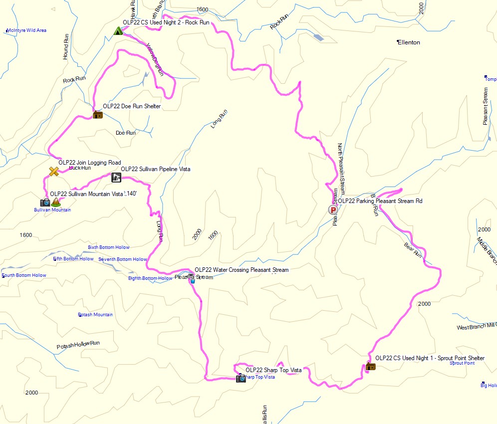
Route Overview – Old Loggers Path Clockwise Backpacking Loop – Sintax77

Continue reading

Lean-to Shelter Camping – Tuscarora Trail

3 days of Backpacking and Hammock Camping on Virginia’s Tuscarora Trail.

For this backpacking trip, I decided to head down to the border of West Virginia and Virginia to check out a pretty cool mountaintop lean-to shelter and do a little airplane scavenger hunt in-between the occasional rain showers that always tend to follow me around.  On day one I would hike up to the ridge using the Tuscarora Trail, day two I would base camp and explore, and on day three I would hike back out via a different set of trails to complete the loop.

My options for shelter would be to either use the Gerhard Shelter lean-to if I had the place to myself, or a lightweight tarp and minimalist hammock if I decided to wander out further into the woods and camp near the search area and nearby spring.

My April temperature range for this trip was between 40° and 75°.  This allowed me to get my backpack’s base weight down to around 10 lbs, while still including my puffy jacket and ultralight rain jacket for supplemental warmth at camp if needed.

The details of the aviation accident site that I was looking for can be found here.  It was a small Cessna 150J that went down due to engine power loss and fortunately their were only minimal injuries to one of the two passengers.  I’ve never read any reports of anyone actually finding or visiting this site, so I really had no idea if there would be anything to be found. But hey, it was a good excuse to get out into the woods, so I grabbed my pack and headed out for some adventure…

Route Overview – Gerhard Shelter Tuscarora Trail Backpacking Trip 2022 – Sintax77

Continue reading

Hammock Camping the Linville Gorge Wilderness – Grand Loop

3 days of Hammock Camping & Solo Ultralight Backpacking on a 40 mile Grand Loop of the Linville Gorge Wilderness.

For this backpacking trip, I headed back down to North Carolina’s Pisgah National Forest for some hammock camping and another attempt at the “Grand Loop”, a roughly 40 mile trek with 11,000 feet of gross elevation gain.

The Linville Gorge Grand Loop is not a single official trail.  It’s actually a patchwork of several official and unofficial trails.  In fact, due to the extensive network of unofficial trails in the Gorge, there isn’t really any one “real” way to do the loop.  The basic goal is simply to circumnavigate the gorge, hiking along the Linville River on the west side, and along the ridge top of the gorge on the east side.  Whatever trails you decide to use is really up to you.

The upper ridges stand an average of 1,400 feet above the river banks below, with trails frequently descending down to the river and back up again on rugged terrain, without signage or trail blazes, and minimal use of switchbacks.   This can make for some challenging hiking, that I personally believe to be some of the toughest on the east coast.  The pay off is a heavy sense of adventure compared to traditional trails and some amazing mountain top views of the surrounding Blue Ridge Mountains.

  • Thank you to Upstart for sponsoring this trip.  See how they can help you build your credit and get free of high interest debt at Upstart.com/Sintax

My mid-May temperature range for this trip was between 45° and 85° with no rain in the forecast until the end of the third day.  This allowed me to get my backpack’s base weight down to around 9 lbs by leaving my puffy jacket and extra base layers at home.  I simply packed a long sleeve shirt and my ultralight rain jacket for supplemental warmth at camp if needed.

I went with a fairly minimalist hammock camping setup for this trip.  There are plenty of trees and fun unofficial campsite gems to be found in the Gorge that make it ideal for hammocks.  Water is obviously of minimal concern for the lower regions of the gorge.  This allows you to save some weight on trails in those sections, but make sure to stock up when your route heads up towards the ridge.  Especially if you’re looking to camp in one the beautiful ridge side campsites up there.  Fortunately, I was able to take advantage of several springs up on the ridge that were still flowing at the time of my trip.

A free permit is required on weekends and holidays from May 1st through October 31st each year. You can find more information on the NFS Grandfather Ranger District website here.

If planning your own trip, I would highly recommend visiting LinvilleGorge.net for maps, info and extensive GPS data including official and unofficial trails, campsites, water sources, etc. They also have a free version of their map available on the Avenza phone app.  Due to the fact that their data is so darn good, I didn’t package my own GPS file for this trip, but you can use this Caltopo link that someone from LinvilleGorge.net posted containing all of the trails and POI coordinates

Route Overview – Linville Gorge Grand Loop Backpacking Trip 2022 – Sintax77

Continue reading

Camping in Heavy Rain – Pinchot Trail South Loop Backpacking Trip

Join Sara and I for some Spring Backpacking, Camping in the Rain, and Trail Cooking on the Pinchot Trail southern loop.


FTC Disclosure: This post contains affiliate links, which means I may receive a commission for purchases made through some of my links.

For this early spring camping trip, my wife Sara and I set out to do some backpacking  with our dog and explore Pennsylvania’s Pinchot Trail southern loop.  I had done the northern loop a couple of weeks before and it was quite nice, so I was looking forward to seeing what this new section had to offer.

For shelter, we packed in our 4 person tent as well as a huge tarp to give us some extra living space during the rain storm that was forecasted to hit in the afternoon and turn into snow by the next morning.

The bottom of the Pinchot Trail South loop runs along Choke Creek, which offers a string of 6 or so beautiful waterside campsites over the course of a mile or so. Legend has it that the last of those campsites is the most picturesque, so our goal was to hike in a few miles to the creek and get to that coveted campsite before the afternoon rain started. If the weather broke early, we would aim to take one of the earlier campsites.

Route Overview – Pinchot Trail South Backpacking Loop – Sintax77

Continue reading

50 Miles of Hammock Camping in 3 Days – Backpacking on Cranberry Lake

3 days of Backpacking & Hammock Camping along Cranberry Lake in the Adirondacks

FTC Disclosure: This post contains affiliate links, which means I may receive a commission for purchases made through some of my links.

For this adventure, I decided to do a fall backpacking trip with some higher trail mileage than I’ve been doing lately. Nestled in New York’s Five Pond Wilderness, the Cranberry Lake 50 is a fifty mile loop hike that circumnavigates it’s namesake, and passes by many smaller ponds along the way as well. Most of these smaller ponds have campsites or even a lean-to shelter nearby, which is quite nice.

The CL50 is not really an individual trail, but a collection of trail sections from 12 other trails is the area.  The route is well blazed with blue CL50 plastic discs nailed to trees along the way.  The trails used to make up the CL50 are blazed with similar yellow trail discs, so you will often see both blazes simultaneously.

The Cranberry Lake 50 goes directly through two towns – Wanakena, where I started, and the town of Cranberry Lake.  There’s only about 10 trail miles between them, so neither really poses much logistical value for resupplying, but they are nice towns to stroll through.

I chose to do the loop counter clockwise from Wanakena because the last 10 miles traverse some muddy wet sections due to beaver dams, so I figured it would be best to save that for the last afternoon.

I typically like to hike my backpacking trips on a 3 day, 2 night timeline, so that meant my daily trail mileage had to be around 17 miles or so during the shortened daylight hours of October.  On the upside, this hike is primarily along the perimeter of a lake, with minimal elevation changes, but did I mention that I hadn’t done a high mileage trip in a while? Yeah, the headlamp got a good amount of usage on this one. Let the night hiking begin…

Route Overview – Cranberry Lake 50 Backpacking Loop – Sintax77

Continue reading

Our Best Campsite Yet – Tongue Mountain Backpacking Trip

Camping and Backpacking in the Adirondacks on the Tongue Mountain Range.


For this overnight backpacking trip, Sara, Denali and I headed up to New York for some laid back camping on the summit of Fifth Peak Mountain, overlooking Lake George. The Tongue Mountain Range is a 3 mile long peninsula, so named because it looks like a tongue jutting out into the 32 mile long Lake George. Our plan was to hike in a few miles to the top of the range and hit the first peak at the top of the peninsula to set up for an afternoon and night of relaxed camping. The next morning we would have the option to either continue along the 13 mile long Tongue Mountain loop, or hike back out the same way we came in.

We had our dog with us, so we decided to return to tent camping for this trip. We did finally upgrade our previous budget tent to a four person (or 2 plus a dog) Marmot Limelight 4p tent though. And as I usually do for trips with my wife and dog, I packed in a massive backpack full of comfort camping gear and fun camp food. A more detailed gear list can be found at the bottom of this post.

Thank you to Anker for sponsoring this video.  My viewers can get $100 off the Anker Powerhouse II 800 by using this link on Amazon or direct from Anker.

Tongue Mountain Adirondacks - Route Overview - Sintax77
Tongue Mountain Adirondacks – Route Overview – Sintax77

There is no permit required for backcountry camping on the Tongue Mountain Range, but there are certain rules and regulations.  You get find more info on the official NY DEC website here.

Full GPS track data, including campsites, water sources, etc, for this trip and many others can be downloaded on my Trip Data Page.

Continue reading