
https://youtu.be/58PJ2Kvlroc
4 Days of Hiking, Camping & Backpacking on Colorado’s Continental Divide Trail in the Rocky Mountain National Forest.
For this backpacking trip, we’ll be doing a 4 day, 3 night camping trip on a section of the Continental Divide Trail in Colorado’s Rocky Mountain National Park. Sometimes referred to as the “CDT Short Loop”, this backpacking loop is a 29 mile mile circuit with several different access point options. In our case, we parked at the Green Mountain trailhead, just past the RMNP Kawuneeche visitor center and park entrance by Grand Lake, CO. The 2 mile Green Mountain trail provided us access to the CDT and brought our mileage for the loop up to 33 miles.
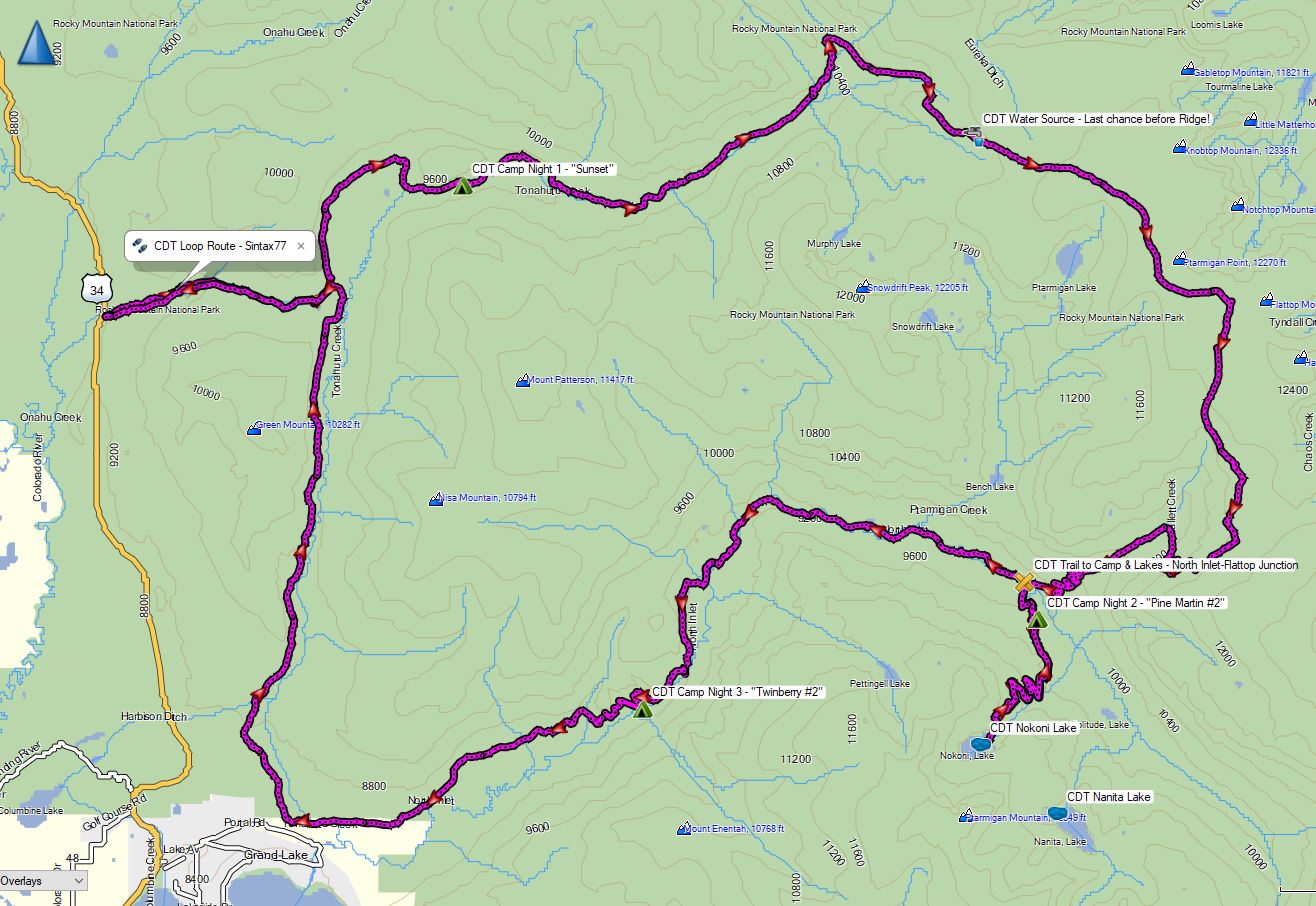
CDT Loop Route Overview – Sintax77
GPS Data for this trip and many others can be found on my Trip Data Page. Includes full track data for each day, and way-points for campsites used, water sources, etc along the loop.
Trailhead Used: Green Mountain Trailhead, RMNP, Grand Lake, CO – 40°18’26.7″N 105°50’28.7″W
This parking area is only a few miles into the park & provides overnight parking for plenty of vehicles. A park entrance pass and wilderness camping permit is required (contact the Kawuneeche Office for details and availability)
Trails Used, Day 1
Park at the Green Mountain Trailhead.
Green Mountain Trail
Junction with Tonahutu Creek Trail (CDT)
Continue north on the Continental Divide Trail
Setup camp at Sunset camp (Elevation 9,498′)
This is a single group tentsite that must be reserved via permit.
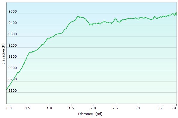
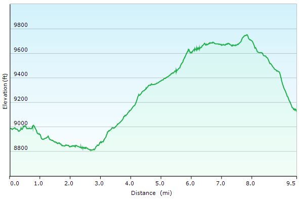
CDT Loop Day 1 Elevation Profile – Sintax77
Day 1 Mileage: 4 miles
Day 1 Gross Elevation Gain: 974′
Trails Used, Day 2
Continue on the Tonahutu Creek Trail (CDT)
Stock up on water before heading up the ridge (last chance at N40° 19.579′ W105° 43.701′)
Continue on Tonahutu Creek Trail (CDT) through Ptarmigan Pass
Junction North Inlet Trail / Flattop Mountain Trail
Head south on the North Inlet Trail (CDT)
Junction North Inlet / Lake Nanita Trail
Head South on the Lake Nanita Trail
Setup camp at Pine Marten Camp (Elevation 9,568′)
These are two separate single group tentsites that must be reserved via permit.
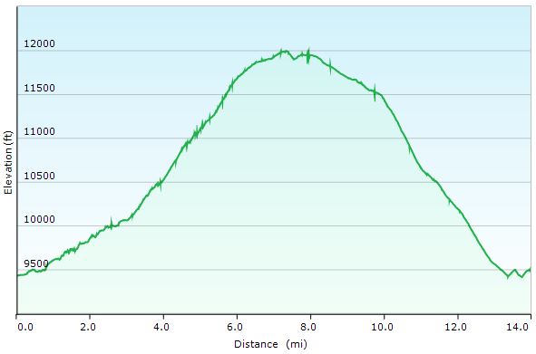
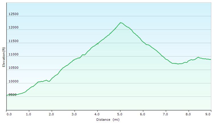
CDT Loop Day 2 Elevation Profile – Sintax77
Day 2 Mileage: 14 miles
Day 2 Gross Elevation Gain: 3,074′
Trails used. Day 3
Dayhike to Lake Nokoni by heading south on the Lake Nanita Trail
We only went to the first lake, Nokoni, due to weather and time issues, but there is a second lake, Nanita, about .75 miles further up the trail.
Backtrack to camp and grab packs.
Return to Junction with North Inlet Trail
Continue west on the North Inlet Trail (CDT)
Setup camp at Twinberry Camp # 2 (Elevation 8,661′)
These are two separate single group tentsites that must be reserved via permit.

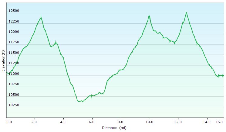
CDT Loop Day 3 Morning Lake Hike Elevation Profile – Sintax77
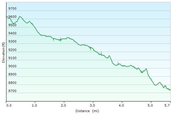
CDT Loop Day 3 Elevation Profile – Sintax77
Day 3 Mileage: 9.6 miles (4 miles round trip for lake hike, 5.6 miles on the CDT Loop)
Day 3 Gross Elevation Gain: 1,414′ (Almost all of this was from the lake hike excursion)
Trails used. Day 4
Continue west on the North Inlet Trail (CDT)
Arrive at the North Inlet Trailhead
Beyond the parking lot, you’ll find the Tonahutu Trailhead
Head north on the Tonahutu Creek Trail
Junction with Green Mountain Trail
Return to Green Mountain Trailhead Parking Lot
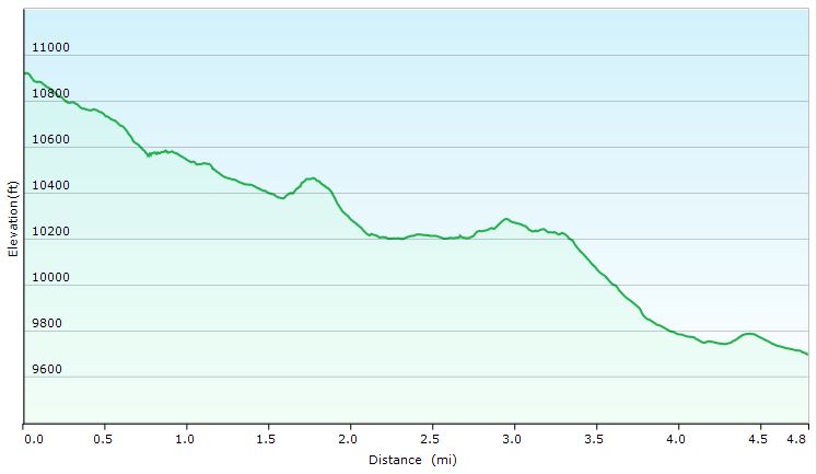
CDT Loop Day 4 Elevation Profile – Sintax77
Day 4 Gross Elevation Gain: 1,204′
Note: 4 miles and 1,414′ can be attributed to our day 3 lake hike)


WrightSocks

Second Skin Blister Treatment

Steripen Ultralight UV Water Purifier

REI Co-op XeroDry GTX Jacket
Hammock Gear Burrow Top Quilts
Outdoor Vitals 15° Down MummyPod Sleeping Bag
Hammock Gear Dyneema Hex Tarp with Doors
2T’s Hammock Chair


 and
and .
.