Camping with Wild Ponies – Solo Backpacking in the Grayson Highlands

3 days of Solo Backpacking, Hiking & Tent Camping on a section of the Appalachian Trail in Virginia’s Grayson Highlands.

FTC Disclosure: This post contains affiliate links, which means I may receive a commission for purchases made through some of my links.

For this 3 day, 2 night backpacking trip, I headed out for some hiking and solo camping in the Lewis Fork Wilderness and Mt Rogers National Recreation Area, within the larger George Washington and Jefferson National Forest.

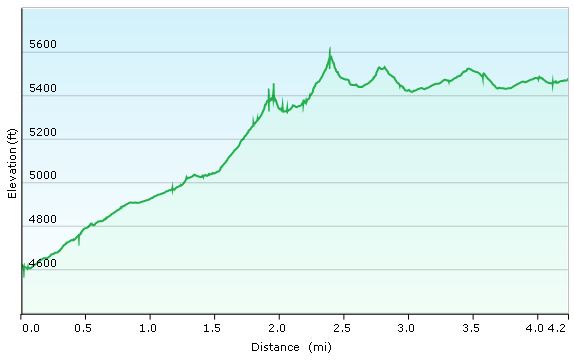
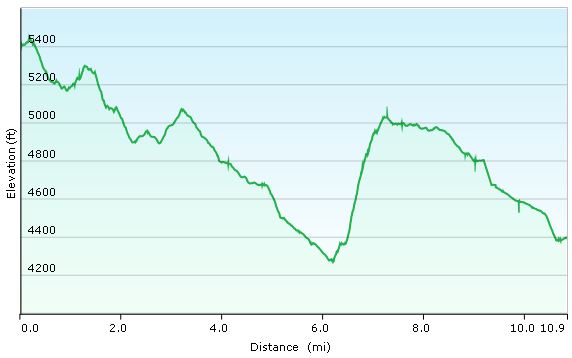
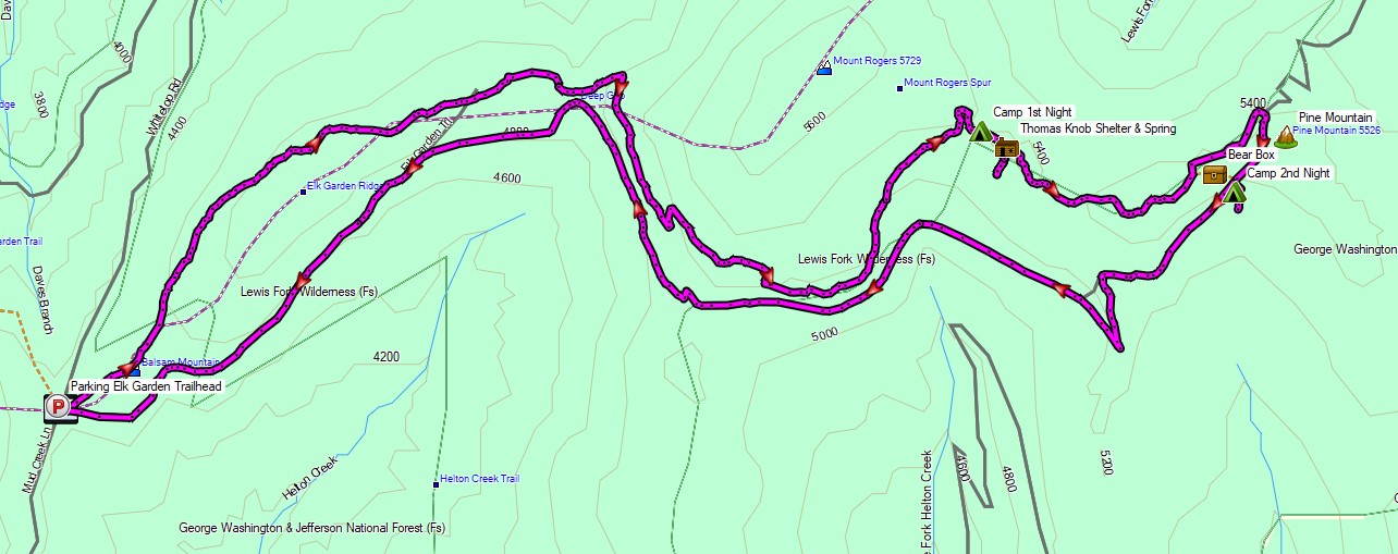
With an emphasis on exploring the wild pony grazing areas surrounding Pine Mountain rather than grinding out mileage, I created a modest loop by combining a portion of the Appalachian Trail with the Virginia Highlands Trail. This gave me a super laid route with my campsites for the first and second nights located in the same general area, separated by less than a couple of miles.

I had a backup plan to do a larger 22 mile loop similar to the one I did in this area a few years back, but I knew from that trip that there was a good possibility I would want to slow things down and soak in the sights in this particular area.  Overall, I was very happy with my choice, but keep in mind that there are many more spots to explore if you’re planning your own trip to the Grayson Highlands.  The details of my previous larger loop can be found here if you’re interested.

The Grayson Highlands are known for their high winds and unpredictable, rapidly changing weather, but luckily for me, the mid September forecast called for an ideal temperature range of 55 to 80 degrees. This allowed me to get by on an ultralight backpacking setup with minimal extra clothing and gear.  My shelter for this trip was my Outdoor Vitals 1p tent in “fast and light” mode –  which just means that I left the main tent body with bugnet at home and set it up using only the tent fly, poles and ground cloth.

Thank you to Revtown Jeans for sponsoring this trip video!

Grayson Highlands Backpacking Trip – Route Overview – Sintax77

Trailhead Used: Elk Garden Trailhead Parking,  36°38’46.7″N 81°34’59.0″W
Whitetop Mountain Rd, Troutdale, VA 24378

This is an easily accessible grass and gravel parking area with room for a decent amount of cars. No fee or permit is required for parking or backcountry camping.  There are pit toilets without running water on site.  I began my hike at the gate on the other side of the road.

Full GPS track data, including campsites, etc, for this trip and many others can be downloaded on my Trip Data Page.

Continue reading

Hiking the Grayson Highlands – Solo Backpacking Trip

Join me for 3 days of Solo Backpacking, Hiking, Hammock Camping, & Wild Ponies on the Appalachian Trail in Virginia’s Grayson Highlands.

For this backpacking trip, I’ll be hiking and camping solo in a section of the Mt Rogers National Recreation Area, within the larger George Washington and Jefferson National Forest.  I’ll be using a portion of the Appalachian Trail to create a 3 day, 2 night backpacking loop of around 20 miles or so.  The Grayson Highlands are known for their high winds and unpredictable, rapidly changing weather, so being that I’m doing the trip in March, I’ll be packing amount of warm weather and rain resistant gear.  If you’re interested in a detailed account of everything that I packed, check out my previous Winter Ultralight Backpacking Gear List blog post and video.  That will give you a look at exactly what I packed for the trip.

Grayson Highlands Backpacking Trip Route Overview – Sintax77

Below is a daily rundown of the trails and campsites used for each day.  Full GPS track data can be found on the Trip Data page.

Parking Location

Grayson Highlands State Park, Overnight Backpacker’s Parking Area at the Massie Gap Parking Lot.  N36° 38.012′ W81° 30.322′

Trails Used, Day 1

  • Depart Massie Gap Parking Lot
  • Rhododendron Trail
  • Appalachian Trail South
  • Wilburn Ridge Trail (it’s also possible to stay on the AT)
  • Rejoin the Appalachian Trail South
  • Setup camp about 200 yards past the Thomas Knob Shelter.

Day 1 Mileage: 4.25 miles
Day 1 Elevation Gain: 2,096′

A spring is about a 100 yards down the trail behind the shelter.

Camping options for tents and hammocks are available a few hundred yards past the shelter, heading south. Tenting spots are on the ridge to the left, hammock camping opportunities are in the trees to the right.

There are also some nice campsite opportunities about a 1/4 mile or so before the shelter as well (AT north from the shelter)

Grayson Highlands Day 1 Elevation Profile – Sintax77

Trails Used, Day 2

  • Continue on the Appalachian Trail South
  • Mt Rogers Trail Towards Grindstone Campground (not to be confused with the Mt
  • Rogers Spur Trail which hits the summit of Mt Rogers.  That trail is available shortly after leaving the campsite.  I’ve heard it doesn’t have any views, but it holds the distinction as Virginia’s highest peak).
  • Lewis Fork Spur Trail (turn here a couple of miles before hitting the campground).
  • Cliffside Trail
  • Crest Trail
  • Scales Trail
  • Setup Camp near the intersection of Scales Trail with the Appalachian Trail

Day 2 Mileage: 11 miles
Day 2 Elevation Gain: 1,320′

There are a number of hammock and tent camping opportunities on the edge of the field opposite from the AT intersection.

There is plenty water in several directions from the intersection. The particular campsite I used (tagged in my GPS data) has water right next to it within 20 yards or so.

Grayson Highlands Day 2 Elevation Profile – Sintax77

Trails Used, Day 3

  • Continue on the Scales Trail South (note: it is possible to continue on the AT
  • South and eventually make your way back to the Massie Gap parking lot as well.  I chose the scales route because it is considerably quicker and I had to do a long drive home upon reaching the lot.)
  • Seed Orchard Trail (this wasn’t on my Nat Geo Map, but after coming out of the woods, you’ll see a sign directing you towards the AT by turning right.  Instead, look left.  You’ll see a water crossing with a brown Grayson Highlands State Park sign listing various rules and regs.  The path along the fence over there is the Seed Orchard Trail)
  • Follow signs towards Hickory Ridge Campground.
  • Past the campground, there will be a large metal gate for a Horse Trail
  • Follow the Horse Trail (there doesn’t seem to be a fancier name for it)
  • Appalachian Spur Trail towards the Backpacker’ s Parking Lot
  • Return the Massie Gap Parking Lot

Day 3 Mileage: 3.5 miles
Day 3 Elevation Gain: 499′

Grayson Highlands Day 1 Elevation Profile – Sintax77


Trip Grand Total Mileage: 18.75 miles
Trip Grand Total Elevation Gain: 3,915′

Map Used for this Trip: National Geographic Map #318, Mt Rogers High Country