Hiking Big South Fork Pt 2 – Tennessee Hammock Camping & Backpacking Trip

Join me for 3 days of hiking & hammock camping on a backpacking trip in Tennessee’s Big South Fork Nat’l Rec Area.

For this backpacking adventure, I’ll be breaking the hiking trip into two parts. BSF Part 1 is mostly in the woods and at camp and is more of a hanging in the woods, conversational type video. Part 2 covers days 2 and 3 where I traverse into the higher regions of Big South Fork, hitting the ridges for views of the Cumberland Plateau’s sandstone bluffs and Big South Fork River.

For more details on the first day of this trip, check out my Big South Fork Pt 1 blog post and video.

GPS Data for this trip is available on the Trip Data Page, or via this link for direct download: Big South Fork Backpacking Loop 2017 GPS Data – Sintax77

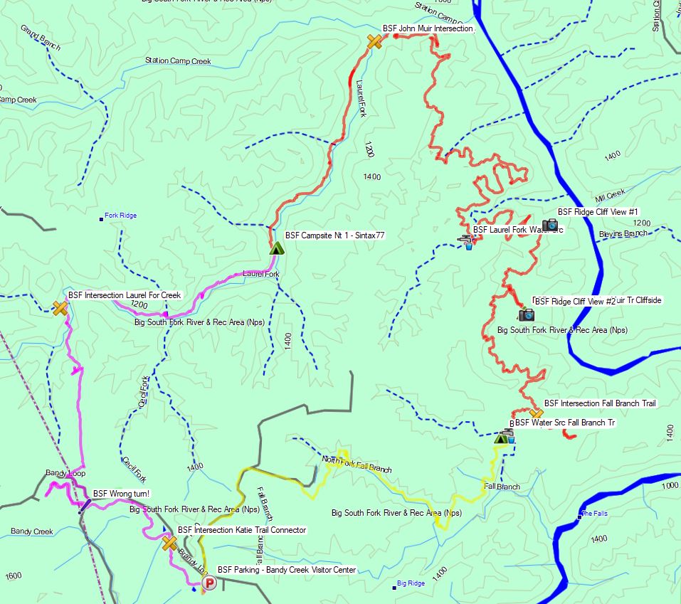
Big South Fork John Muir John Litton Backpacking Loop Route Overview – Sintax77

Trailhead and Parking Location

Bandy Creek Visitor Center, 151 Stable Rd, Oneida, TN 37841
N36° 29.275′ W84° 41.837′

Topics discussed and things that happen in this episode

  • Place Holder

Trails Used Day 2

  • Break camp along the Laurel Fork Creek Trail
  • Continue north on the Laurel Creek Fork Trail
  • Make a left (east) onto the John Muir Trail (the next 2 miles will cover the bulk of the elevation gain for the day)
  • Make a right (west) onto the Fall Branch Trail
  • Setup camp along the Laurel Fork Creek Trail (less than a 100 meters after crossing the creek / bridge.  There is a campsite immediately next to the creek as well)

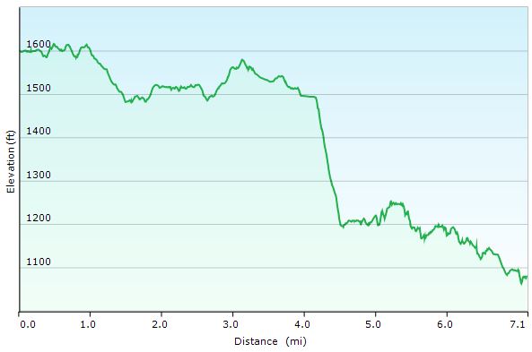
Day 2 Total Mileage: 15.2 miles
Day 2 Gross Elevation Gain: 1,616 feet
Day 2 Gross Elevation Loss: 1,266 feet

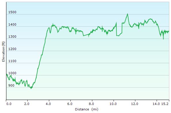
Big South Fork Day 2 Elevation Profile – Sintax77

Trails Used Day 3

  • Break camp along Fall Branch Trail
  • Continue south on the Fall Branch Trail
  • Make a Right (north) onto the John Litton Farm Hike Loop Trail (heading south will ultimately bring you back to the parking lot as well).
  • Continue south onto the road (gravel, then paved) until you arrive back at the Bandy Creek Visitor Center Parking Lot.

Day 3 Total Mileage: 6.1 miles
Day 3 Gross Elevation Gain: 600 feet
Day 3 Gross Elevation Loss: 313 feet

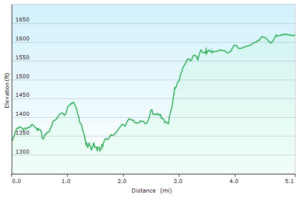
Big South Fork Day 3 Elevation Profile – Sintax77

Trip Grand Totals

Total Mileage for Trip: 28.4 miles
Total Elevation Gain for Trip: 3,076 feet

The gear list used for this trip along with discussion on each item can be found in my accompanying 2017 Ultralight Backpacking Gear List Blog Post and Video.

Hiking Big South Fork Pt 1 – Tennessee Hammock Camping & Backpacking Trip

Join me for 3 days of hiking & hammock camping on a backpacking trip in Tennessee’s Big South Fork Nat’l Rec Area.

For this backpacking adventure, I’ll be breaking the hiking trip into two parts. Part 1 is mostly in the woods and at camp and is more of a hanging in the woods, conversational type video. In BSF Part 2 we will traverse into the higher regions of Big South Fork, hitting the ridges for views of the Cumberland Plateau’s sandstone bluffs and Big South Fork River.

GPS Data for this trip is available on the Trip Data Page or by clicking this link for direct download: Big South Fork Backpacking Loop 2017 GPS Data – Sintax77

Trailhead and Parking Location

Bandy Creek Visitor Center, 151 Stable Rd, Oneida, TN 37841
N36° 29.275′ W84° 41.837′

Topics discussed and things that happen in this episode

  • Feeling like a lost idiot on the trail.
  • Camp setup priorities when arriving at camp.
  • Setup / breaking camp in the rain.
  • Continuous Ridgeline usage and setup for quick and easy tarp deployment.
  • Low carb backpacking food options for carb conscious or ketogenic diets.
  • Starting a campfire in the rain.
  • Campfire cooking some meat on a stick.

Trails Used Day 1

  • Parked at the Bandy Creek Visitor Center
  • Started on the Oscar Blevins Farm Loop Trail (located in the corner of the parking lot on the opposite side of the road from the visitor’s center)
  • At the Intersection, turn right onto the Collier Ridge Bike Loop. This is where I mistakenly continued straight, which would have taken in a circle. Luckily, I realized earlier enough to turn around and head back to the intersection.
  • Turn left (north) on the gravel road. From looking at the map, I could have avoided the short road hike by hopping on the access Jack Ridge trail, which appears to be found either right near where I popped out on the road, or a little ways down that road to the right.  Continuing on the road seems to have saved me a decent amount of hiking though, which made up for my wrong turn earlier,
  • Turn right (east) onto the next, smaller gravel road.
  • Arrived at the sign for Jack Ridge Loop Trail and headed left onto
  • Black House Branch Trail
  • Right on Laurel Fork Creek Trail
  • Setup camp by the waterfall pool along the Laurel Fork Creek Trail.

Big South Fork Day 1 Elevation Profile – Sintax77

Day 1 Total Mileage: 7.25 miles
Day 1 Gross Elevation Gain: 860 feet
Day 1 Gross Elevation Loss: 1,256 feet

The gear list used for this trip along with discussion on each item can be found in my accompanying 2017 Ultralight Backpacking Gear List Blog Post and Video.