
Join the crew as we revisit the Red River Gorge for 3 days of hiking, hammock camping and backpacking in Kentucky.
The Red River Gorge a unique Geological Area within Kentucky’s Daniel Boone National Forest. This area hosts an impressive collection of natural arches (or natural bridges, as they’re often call), spread across some relatively young forest in the hills of eastern Kentucky, about 1 hour shy of Lexington. The Red River Gorge has the highest concentration of rock arches east of the Rock Mountains (over 100). This makes Red River Gorge a visually impressive hiking area, as well as one of the world’s top rock climbing destinations.
This is actually my second exploration of the RRG. My first backpacking experience here was a solo hammock camping trip in October, a couple of years back. On that trip, I covered more ground and saw a nice sampling of the area’s more well known arches, but helpful feedback from some of my viewers who were more versed in the area alerted me to the fact that I had missed out on some pretty cool unofficial trails and spots. In fact, I had walk right by a few of them. I made a mental note to get back down to the Red River Gorge some day and give it another go.
Finally, the opportunity arose for that trip, and to sweeten the deal, I managed to round up an outdoor posse for this renewed exploration the RRG. This time around, I’ll be joined by my wife as well as my friend Mike and his wife Danielle. And while my last trip was a 2 day, higher mileage affair, we decided to extend this backpacking trip to 3 days and to drop the mileage back a bit to create a trip with more emphasis on time to relax at camp. Actually, our night two camp site was one of the very areas that several viewers had suggested I check out on my next visit – an unofficial (but completely legal) camping spot called Hanson’s Point. The actual point has an amazing view out into the gorge, and the nearby camping opportunities are large, flat, and nicely shaded.
The route we chose for this trip starts out at the same trailhead as my previous Red River Gorge trip video, but shortly after starting, it deviates onto an unofficial spur trail for another viewer suggested feature, called Indian Staircase. This area offers an impressive view into the gorge as well. It also boasts a pretty cool feature that gives it it’s name – a series of foot and hand holds carved into it’s sandstone face to assist with traversing it’s steep grade. As the name would suggest, legend says that local Native Americans originally created these features, but who actually created these carvings remains a mystery and the source of some debate. Regardless of the true history, it’s a very cool place and well worth checking out. While I didn’t personally find the route overly steep or exposed, it should be pointed out that this trail could be a bit nerve wracking for some sensitive to heights. Leaving you pack stashed at the base is certainly helpful and will save you a few ounces of sweat as well.
GPS track data along for each day’s hiking route, along with waypoints for campsites and other points of interest, can be downloaded on my Trip Data page.
Trails Used, in order (with Trail Numbers):
Park at Bison Way Trailhead 37.83685,-83.609546
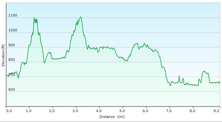
Day 1
Bison Way Trail 210
Unofficial Spur Trail to Indian Staircase at GPS coordinates
Sheltowee Trace Trail 100
Cross State Road 715 and River via suspension bridge
Rough Trail 221
Set up camp along Chimney Top Creek
Stats for Day: 9.2 Miles ; 1,413 feet of elevation gain
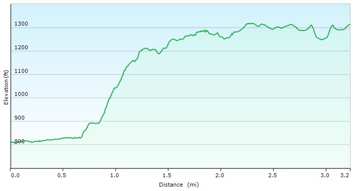
Day 2
Rough Trail 221
Hanson’s Point Spur Trail (unoffcial)
Set up near near Hanson’s Point
Stats for Day 2: 3.2 Miles ; 731 feet of elevation gain
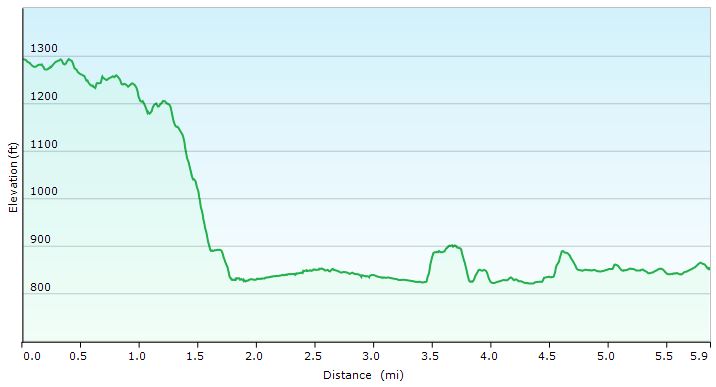
Day 3
Hanson’s Point Spur Trail (unoffcial)
Rough Trail 221 (short segment towards Sheltowee Tr )
Sheltowee Trace Trail 100
Road Hike along Red River back towards Bison Way parking area.
Stats for Day 3: 5.9 Miles ; 377 feet of elevation gain.
Grand Totals for Trip: 18.3 Miles ; 2,521 feet of elevation gain