How to Survive an Ice Storm – Hammock Camping the Roaring Plains

3 Days of Winter Hammock Camping and Backpacking in the Roaring Plains Wilderness during Snow and Freezing Rain.

FTC Disclosure: This post contains affiliate links, which means I may receive a commission for purchases made through some of my links.

For this late winter backpacking trip, I decided to head back down to West Virginia’s Monongahela National forest to do some ridge hiking and cold weather hammock camping. Due to temperatures forecasted from the low 20’s to the low 40’s, I needed to pack in some heavier warm clothing layers for this trip, along with some camp tools, so I used my larger winter backpack.  For sleep and shelter, I used my go-to ultralight hammock and tarp set-up with winter grade down quilts (full gear list below).  As it turns out, I probably should have used that extra pack space for a larger tarp too, but live and learn I guess…

This trip video was sponsored by Magic Spoon.  You can try their variety pack and get $5 off by using this link and the code Sintax77.

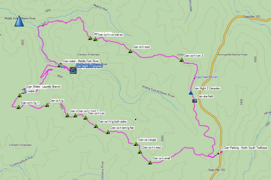
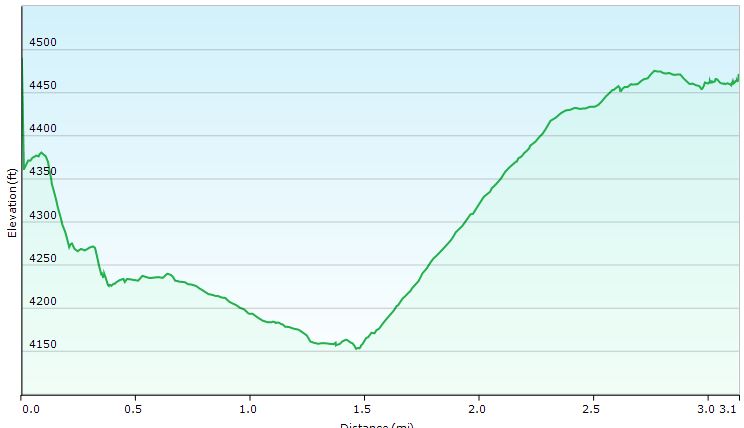
The 6,792 acre Roaring Plains West Wilderness is a remote federal wilderness area located about 3 miles south of the more popular Dolly Sods Wilderness Area.  It boasts a healthy network of trails, which are unmarked and often, grown in and hard to follow.  Official paper maps are hard to come by, and by some accounts, not very up to date.  Based on my personal experience, I would highly recommend using a GPS with appropriate data while hiking here.  You can also find good trail info and map print-outs at MidAtlanticHikes.com and HikingUpward.com.  I also recorded my personal GPS data for this trip, which can be found here.

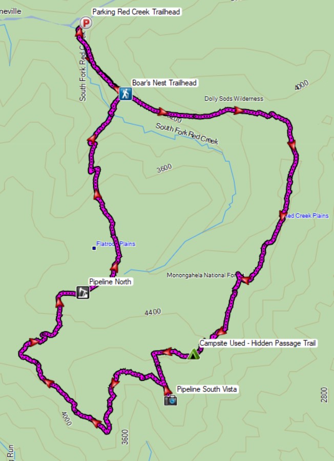
Route Overview – Roaring Plains Backpacking Loop – Sintax77

Continue reading

Deep Woods Camping & Finding a Cessna 414

FTC Disclosure: This post contains affiliate links, which means I may receive a commission for purchases made through some of my links.

For this backpacking trip, we hiked into the Cranberry Wilderness in search of a twin engine private plane that crashed in 1995 and went missing for 6 years, deep in the forests of a remote West Virginia mountaintop.  There was also a hiker who went missing here back in 2011.

For sleep and shelter, Frank and I both decided to pack in our Amok Draumr Hammock camping systems. This would allow us to get a comfortable camping setup even if we were forced to camp in one of the mossy rock fields that are often encountered along mountain ridges in the Cranberry Wilderness.  A detailed gear list can be found at the bottom of this post.

On the morning of November 28th, 1995, a Cessna 414, tail number N28901 took off from Braxton County Airport in Sutton, West Virginia headed for Lynchburg Regional, Virginia.  After encountering low visibility due to foggy conditions, the lone pilot contacted air traffic control to request an IFR (instrument flight rules) flight plan in order to continue navigating the approaching mountainous terrain.  After a period of apparent poor communications, possibly due to a radio issue, ATC lost contact with the pilot.  Transponder signals ceased not long after the last communication, and the plane was never heard from or seen again until it was spotted from the air over six years later.

More info on N28901 can be found in this copy of the NTSB report.

Cranberry Wilderness Cessna 414 Search Route Overview - Sintax77

Route Overview – Cranberry Wilderness Cessna 414 Backpacking Trip  – Sintax77

No permit is required to backcountry camp in the Monongahela National Forest.

Full GPS track data, including campsites, etc, for this trip and many others can be downloaded on my Trip Data Page.

Trailhead Used: Big Beechy Trailhead, 38°17’44.2″N 80°14’55.7″W
Highland Scenic Hwy, Minnehaha Springs, WV 24954

Continue reading

Fall Camping in Dolly Sods – Foliage Peaking and Sleeping Pads Leaking

Join Sara and I for 3 Days of Camp Cooking, Hiking, & Backpacking in the Dolly Sods  Wilderness.

For this 3 day, 2 night backpacking trip, Sara, Denali and I decided to do some fall foliage camping in West Virginia’s Dolly Sods Wilderness, part of the larger Monongahela National Forest. Dolly Sods is located in the Allegheny Mountains on the highest plateau east of the Mississippi river and features some of the most varied and scenic terrain available to hikers in the Mid-Atlantic region.

We had our dog with us on this trip, so we decided to give tent camping a go this time around to keep us all together in one spot.  I also decided to totally throw lightweight backpacking out the window for this trip, so I brought along my Fjallraven Kajka 75 backpack and stuffed it to the gills with various backpacking gear, just to have a little fun and switch things up a bit (gear list at end of post).  This decision was made easier by the fact that we were starting at Bear Rocks trailhead, which is already high up on the plateau with minimal elevation changes.

Campsites and great views are fairly abundant in Dolly Sods, so our general plan was to keep the mileage low and focus on a relaxed hiking pace, fun backpacking food and camp cooking.  It was the perfect recipe for a laid back camping trip.  Other than the whole leaking sleeping pad situation to make things more interesting…


Route Overview – Dolly Sods Fall Backpacking Loop – Sintax77

No permit is required to camp in the Dolly Sods Wilderness, but there are rules and regulations regarding backcountry camping. You can find more information on the USFS Dolly Sods website here.

Full GPS track data, including campsites, water sources, etc, for this trip and many others can be downloaded on my Trip Data Page.

Continue reading

Hammock Camping with my Dog – Seneca Creek Hiking & Backpacking Trip

Join my dog Denali and I for some Hiking, Backpacking, and Hammock Camping in the Seneca Creek Backcountry.

For this hiking adventure, my pup and I will be visiting the Spruce Knob-Seneca Creek National Recreation area, within West Virginia’s greater Monongahela National Forest. Our route will be a “lollipop”style hike – meaning we’ll use an “out and back” section of trail from the Spruce Knob trailhead parking area to connect with a series of other trails that form a loop. After completing the loop portion of the hike, we’ll backtrack out using the same section of trail from day one.

The Spruce Knob-Seneca Creek Backcountry offers around 60 miles of trails (marked with blue blazes) with an elevation range of 3,000 to 4,800 feet above sea level. The beginning of this particular loop is actually the highest point in all of West Virginia – Spruce Knob – standing at and elevation of 4,861 feet. Below is a list of trails for each day, along with stats for elevation gain and mileage.

Trailhead Parking: Spruce Knob Parking area (right by the observation tower).

Parking Notes:  No parking fees or overnight permits are required.  There are restrooms and bear-proof trash bins available for use.

GPS Track Data for this trip can be found on my Trip Data Page.

Trails used, Day 1

  • Huckleberry Trail
  • Hornton Trail (just for a short bit)
  • Judy Springs Trail
  • Seneca Creek Trail
  • Hammock Camp along Seneca Creek.

Day 1 – Seneca Creek Loop elevation Profile – Sintax77

Day 1 Mileage: 6.5 miles
Day 1 Gross Elevation Gain:  221 feet (pretty much down hill all day)

Trails used, Day 2

  • Seneca Creek Trail
  • High Meadows Trail
  • Lumberjack Trail
  • Join back up with Huckleberry Trail
  • Arrive back at Spruce Knob Parking Lot

Day 2 – Seneca Creek Loop elevation Profile – Sintax77

Day 2 Mileage: 10 miles
Day 2 Gross Elevation Gain:  2,173 feet (pretty much up hill all day)

Notable Gear Seen in the Video

Denali’s Hammock – 2T’s Hammock Chair from Dutchware
Denali’s Dog Backpack – “One Tigris Cotton Canvas Dog Pack”
Denali’s Collapsible Dog Dish – Doggone Dish
Dutchware Chameleon Hammock
Hammock Gear Burrow 40 Top Quilt

Hammock Gear Phoenix 30 Underquilt
Hammock Gear Cuben Hex Tarp
Katadyn BeFree Water Filter
Toaks 750ml Titanium Pot
Vargo Windscreen
Esbit Solid Fuel Cubes
ULA Ohm 2.0 Backpack

Aerial Photography – DJI Mavic Pro
Primary Camera – Blackmagic Pocket Cinema Camera

Ultralight Backpacking in the Cranberry Wilderness

Come along for 3 days of ultralight backpacking and fall camping in West Virginia’s Cranberry Wilderness.

For this adventure, I’ll be taking my newly refined ultralight backpacking loadout for a three day overnight hiking and camping trip in West Virginia’s Cranberry Wilderness.  After my last couple of vista-packed trips, I’ve had some requests for more footage & discussion once we get to camp – site selection, shelter setup, fire making, cooking, etc.  Well, this video has plenty of all that, and then some.  In fact, this ended up being my longest feature length video so far.

For those of you looking for something a little lighter, there’s a full back catalog of shorter videos that might hit the spot, but if you’re ready to get into the finer details of ultralight backpacking gear and spending time outdoors (from my own warped perspective of course), then this is the video for you.  A little gift for the hardcore fans 😉

Overview of the route I took. Recorded with my Garmin Oregon 650 GPS.

Overview of the route I took. Recorded with my Garmin Oregon 650 GPS.

Parking: North South Trailhead on State Route 150
38.276530, -80.237829


Trails Used Day 1
Start at North South Trail Head on West Virginia SR 150
TR 688 North South Trail
TR 267 Laurelly Branch Trail
TR 271 Middle Fork Trail
Setup Camp on Hell for Certain Branch
This is a large campsite across from trail on opposite side of the Middle Fork River with plenty of fresh water available from the nearby river.

Cranberry Wilderness Day 1 Elevation Profile
Day 1 Total Mileage: 13.2 miles
Day 1 Gross Ascent: 1,102′

Trails Used Day 2
Backtrack on TR 271 Middle Fork Trail towards junction from previous day
Continue on TR 271 Middle Fork Trail
TR 207 Big Beechy Trail
Setup Camp just after summit of Sugar Creek Mountain.
This is a medium-small Campsite, in a beautiful mossy area.  Make sure to pack in enough water, as there are no nearby sources.  The elevation was around 4,400 feet and the landscape was somewhat conducive to wind, so be prepared for temps that are possibly quite a bit lower than locally forecasted.

Cranberry Wilderness Day 2 Elevation Profile 
Day 2 Total Mileage: 9.06 miles
Day 2 Gross Ascent: 2,405′

Trails Used Day 3
Continue on TR 207 Big Beechy Trail
TR 272 North Fork Trail
TR 688 North South Trail towards SR 150
Return to North South Trailhead Parking Lot

Cranberry Wilderness Day 3 Elevation Profile
D
ay 3 Total Mileage: 3.17 miles
Day 3 Gross Ascent: 367′

Total Mileage for Trip: 25.39 miles
Total Gross Ascent for Trip: 3,974′

Click Here to Download a PDF Copy of the Gear List used for this Trip
or visit the Gear Lists Page for detailed notes and weights for each item.

Notable Pieces of Gear seen in this Video:
Dream Hammock Darien Hammock
with cinch buck suspension and Dutch Clips
Hammock Gear Cuben Hex Tarp 12’x8.5′
Zing-It Guy lines with Dutch Wasps for tensioning
Osprey Hornet 46 Backpack
Hammock Gear Burrow 40 Top Quilt
Hammock Gear Incubator 40 Underquilt
Frogg Toggs Rain Jacket
Esbit Solid Fuel Cubes
Toaks 750ml Titanium Pot with lid
Vargo Windscreen / Pot stand
Sawyer Mini Water Filter
Montbell UL Parka – 850 fp down
Adidas Terrex Swift-R trail runners