3 Days of Ultralight Backpacking & Hammock Camping on the Carter-Moriah Range in the White Mountains of New Hampshire.
FTC Disclosure: This post contains affiliate links, which means I may receive a commission for purchases made through some of my links.
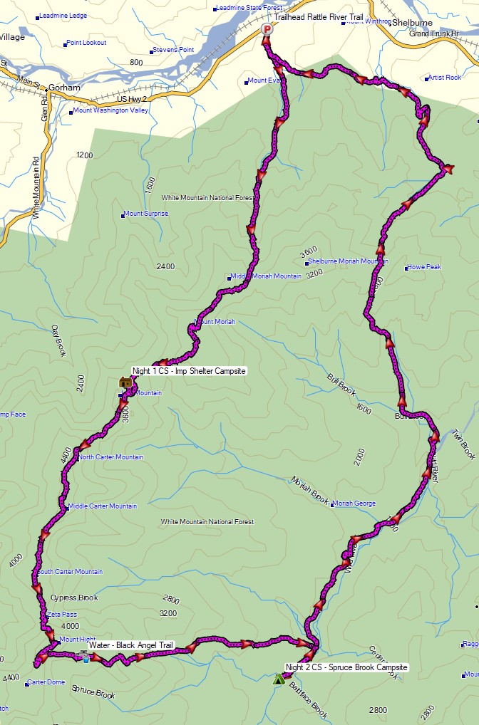
For this summer backpacking trip, I headed up to the Wild River Wilderness to create a 36 mile hiking loop with 10,000 feet of gross elevation gain by linking together the Appalachian trail with several other lesser used and more rugged trails in the White Mountain National Forest.
My June temperature range for this trip was between 35° and 85° with a chance of rain each day, but mostly during the night. Due to the wide temp range and the unpredictable weather typically encountered in the White Mountains, I packed in a puffy jacket and some ultralight rain gear for additional protection against the elements. This brought my pack’s base weight right up to around the 10 lb mark.
Thank you to Upstart for sponsoring this trip. See how they can help you build your credit and get free of high interest debt at Upstart.com/Sintax
I went with my standard minimalist hammock camping setup for this trip. While I planned to stay at officially recognized campsites, I still wanted the ability to camp at a legal, but unofficial spot if the opportunity or need arose. Due to the dense vegetation and uneven ground found at upper elevations in the Whites, I’ve learned that a hammock is often the only realistic option in those types of conditions.
Water would be plentiful along the river portion of my loop, but would only be reliably available at Imp campsite during the ridge hike section, so I had to plan accordingly for that during the first half of my trip. The second half of my trip would have more water, but would be on more challenging trails. Notably, the Black Angel Trail, a rugged and minimally maintained wilderness trail, and the Highwater Trail, which suffered substantial washouts and haphazard re-routes due to storm damage from Hurricane Irene back in 2011.
Route Overview – WIld River Carter-Moriah Backpacking Loop – Sintax77
Backpacking & Winter Camping on the side of Mount Washington.
FTC Disclosure: This post contains affiliate links, which means I may receive a commission for purchases made through some of my links.
For this adventure, I headed back up to the White Mountains of New Hampshire to do some snow camping and make another attempt at doing a Mt Washington winter ascent for some frozen views of the Presidential Range. I tried this about a year ago, but a stomach bug and 85 MPH winds kind of put a damper on things. This time around, I also brought a hiking partner, Frank. We’ve done several winter trips together so far, but this would be his first time in the White Mountains.
Similar to last year’s trip, the plan was to set up a base camp at higher elevation, followed by a lighter weight trek up to the top of Mount Washington if weather conditions and visibility were agreeable. If the conditions were questionable, we made a back-up plan to scurry up the side of the nearer Mt Monroe. And of course, if the weather really got bad, we would just play it safe and stay below tree line.
Trailhead Used: Ammonoosuc Ravine Trailhead
44°16’01.2″N 71°21’40.7″W
Base Station Rd, Jefferson, NH 03538
This is a large parking lot with room for many vehicles. A parking fee of $5 dollars per day or an annual National Park pass is required.
Trails Used
Ammonoosuc Ravine Trail
Appalachian Trail (Crawford Path)
Mt Monroe Loop Trail
Campsite
Camp along Ammonoosuc Trail 44.26398, -71.32182
This was a small unofficial campsite located in a hollowed out spot not too far before entering the Lakes of the Clouds Forest Protection Zone.
Backpacking & Solo Winter Camping in search of a 1954 commercial airline crash near the summit of Mt Success in the White Mountains.
FTC Disclosure: This post contains affiliate links, which means I may receive a commission for purchases made through some of my links.
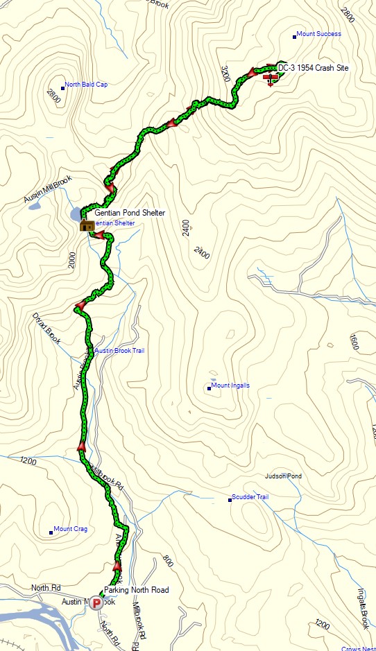
For this 3 day, 2 night camping trip, I headed up to a lesser traveled corner of New Hampshire’s White Mountain National Forest for some snowshoeing, camp cooking, and bit of New England aviation history.
My goal for this adventure was to find the resting place of Northeast Airlines Flight 792, which crashed on approach to Berlin Municipal Airport during inclement weather on November 30th, 1954. It made contact in the dense trees near the summit of Mt Success at an elevation of 3,390 feet. More information on the details of Flight 792 and the circumstances of it’s survivors can be found in this copy of the official Accident Investigation Report
The 6.5 mile hike to get there would require a gross elevation gain of roughly 3,700 feet on potentially unbroken trail in deep snow. The final portion of the hike would be an unofficial bushwhack through dense trees and snow. For this reason, I chose to break up the approach up by setting up camp at roughly the halfway point along Gentian Pond and the nearby lean-to shelter with sweeping views of the Carter-Moriah mountain range. After camping for the night, I would head up to the top of Mt Success, the first peak of the Mahoosuc Range and the Appalachian Trail’s gateway to Maine. After a few miles and a couple thousand feet of ascent with my trusty snowshoes, I would leave the trail behind in search of the DC-3.
No permit is required to backcountry camp in the White Mountains, but some locations do require a daily, weekly, or annual pass. The parking area for this trip did not require a parking fee as of January 2021.
3 Days of Winter Hammock Camping, Backpacking, & Snow Hiking in New Hampshire’s White Mountains using the Amok Draumr XL Hammock.
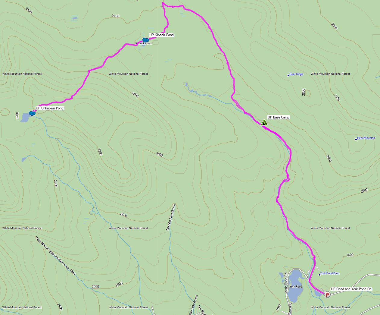
For this 3 day, 2 night spring snow camping trip, I’ll be hiking a section of trail in northern New Hampshire to setup a winter base camp in the remote Mt Cabot & Unknown Pond region of the White Mountain National Forest.
For sleep and shelter I packed in my Amok Draumr XL hammock, paired with the Amok Borg tarp and Amok Fjol XL sleeping pad. I had never used the Amok hammock on a winter trip before, so I figured this would be a good opportunity to test it, as the forecast called for a decent amount of snow and temperatures a little bit below it’s recommended temperature range of 20°F. More details on my winter backpacking gear can be found at the end of this post.
Unknown Pond Route Overview – Sintax77
No permit is required to camp in the White Mountains NF, but there are rules and regulations regarding backcountry camping. You can find more information on the USFS White Mountains website here.
3 Days of Hammock Camping, Hiking & Backpacking on the White Mountains Presicat Loop.
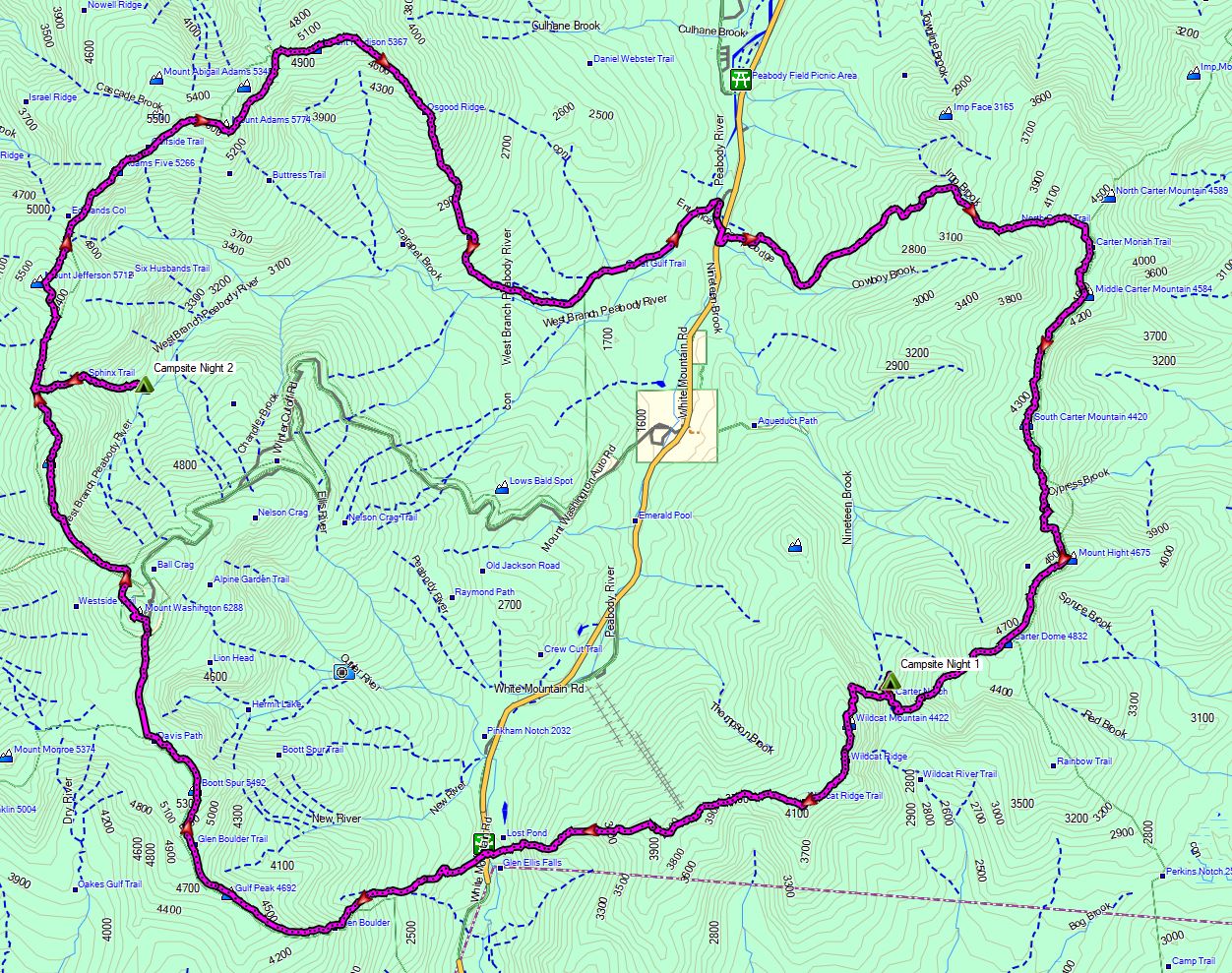
For this 3 day, 2 night summer backpacking trip, I’ll be hiking a 30 mile backpacking loop in New Hampshire’s White Mountain National Forest. I call this the Presicat loop because it’s comprised of the Carter Range and Wildcat Range on one side, and the northern section of the Presidential Range on the other.
This route creates a grand tour of the northern White Mountains with a section of the Appalachian Trail and Mt Washington as it’s centerpiece. Along the way we’ll hit 9 major summits (NH48’s) and 8 subsidiary peaks, while racking up 15,228 feet of elevation gain on some pretty rugged trails.
For sleep and shelter I chose a minimalist ultralight hammock camping system. This allowed me to get my base weight down to 9 lb. Notable gear can be found in the gear section below. Or check out my full printable list with weights and links on LighterPack.
Presicat Loop Route Overview 2019 – Sintax77
No permit is required to camp in the White Mountains, but the trailhead I chose did require a self payment of $3 per day. Rules and regulations regarding backcountry camping can be found on the USFS website here.
Join Mike & I as we Attempt to Winter Camp in a Snow Trench at -15° F, Deep in the Woods of the White Mountains.
For this winter backpacking & Snow Camping adventure, we’ll be heading into the austere terrain of the Dry River Wilderness in New Hampshire’s White Mountains. Our main challenge for this adventure will be to sleep without the comforts of a tent of hammock. Our goal is to use bivvy sacks to protect our sleeping bags from the elements as well as extend the range of our sleeping bags. The latter of which is of particular importance because we’ll be packing in sleeping bags rated for around 15° to 20° F, in temperatures of around -15° F. Our secondary objective will be to hit the summit of Mt Crawford, replete with stunning, 360° views of the White Mountains. Oh, and we’ve got some pretty fun backpacking food on the menu as well. We’ll be camp cooking all “real food” on this trip, thanks to the sub-zero temps, no traditional dehydrated backpacking food.
Route Overview – Snow Trench Camping – Sintax77
Topics Covered in this Episode
Winter Campsite selection, via topographical maps, and well …pure luck.
Winter camping snow shovels (see gear list below for further details)
The complications of cooking backpacking food in sub-zero winter conditions.
Digging a winter camping shelter in the snow, along with tarp setup, should you be lucky enough to have one available (we did).
Building a fire on top of snow (not nearly as hard as you might think it is – even on the 6+ feet of snow that we had to deal with).
Sleeping in a snow trench with a SOL Escape Bivvy sack.
The balance of hitting a winter summit, versus well, not eating, hydrating or, you know -surviving.
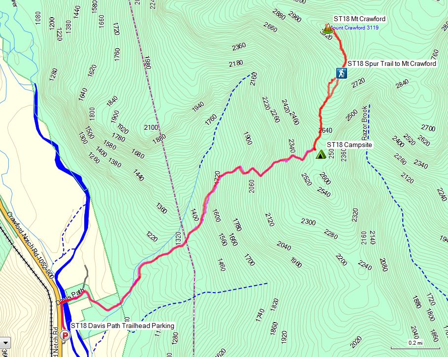
Trailhead Parking
Davis Path Trailhead, Crawford Notch Rd, Bartlett, NH 03812
Setup camp in the flat area found around 2,500′ along the Davis Path Trail.
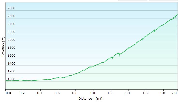
Elevation Profile Day 1 – Snow Trench Camping – Sintax77
Day 1 Mileage: 2.0 miles Day 1 Elevation Gain: 1,725′
Stats & Trails Used, Day Two
Wake up, get a campfire going, and cook some soup for breakfast to get fueled up.
Grab some essential items (snacks, water, camera gear) and leave the majority of gear at camp to keep things fast and light for the upcoming high winds summit attempt.
Rejoin Davis Path Trail and head north.
At the junction, take the Mt Crawford Spur Trail, towards the summit of Mt Crawford.
Head back down the same way, to return to base camp and pack up the bulk our remaining items.
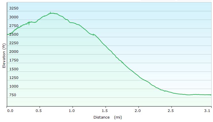
Elevation Profile Day 2 – Snow Trench Camping – Sintax77
Day 2 Mileage: 3.1 miles *0.65 miles to the summit of Mt Crawford, 2 miles from camp to the Davis Path Trailhead Parking Lot. Day 2 Elevation Gain: 974′
Trip Totals Total Elevation Gain: 2,699′
Total Mileage: 5.1 Miles
Notable Gear Used / Seen on this Backpacking Trip:
Traction & Traversal
MSR Denali Ascent Snowshoes *No longer in production, I got them on Ebay. A modern equivalent would be something like the MSR Evo Ascent Snowshoe. Kahtoola Micro Spikes *I didn’t end up using them, as I had my snowshoes on most of the time, but I always throw these in the pack for snow trips to deal with icy terrain. Trekking Poles – CNOC Outdoors Carbon Fiber Vertex Trekking Poles


 – Emergency Bivvy Sack for Survival and Camping
 , long


 *No longer in production, I got them on Ebay. A modern equivalent would be something like the
  .
. *I didn’t end up using them, as I had my snowshoes on most of the time, but I always throw these in the pack for snow trips to deal with icy terrain.
 *I’m not sure my model is in production anymore. The closest current version seems to be the
  .
.
