3 days of Backpacking and Hammock Camping on Virginia’s Tuscarora Trail.
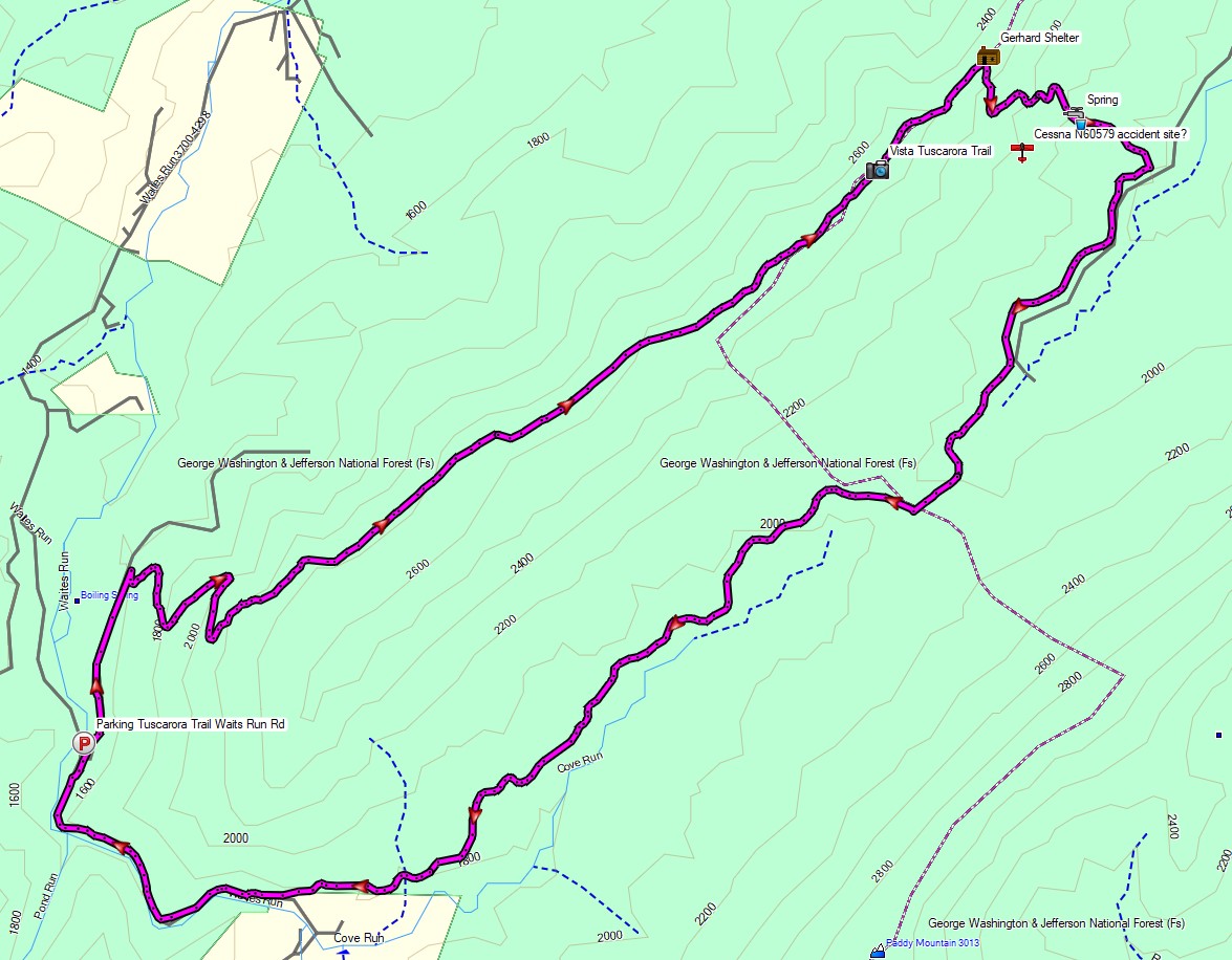
For this backpacking trip, I decided to head down to the border of West Virginia and Virginia to check out a pretty cool mountaintop lean-to shelter and do a little airplane scavenger hunt in-between the occasional rain showers that always tend to follow me around. On day one I would hike up to the ridge using the Tuscarora Trail, day two I would base camp and explore, and on day three I would hike back out via a different set of trails to complete the loop.
My options for shelter would be to either use the Gerhard Shelter lean-to if I had the place to myself, or a lightweight tarp and minimalist hammock if I decided to wander out further into the woods and camp near the search area and nearby spring.
My April temperature range for this trip was between 40° and 75°. This allowed me to get my backpack’s base weight down to around 10 lbs, while still including my puffy jacket and ultralight rain jacket for supplemental warmth at camp if needed.
The details of the aviation accident site that I was looking for can be found here. It was a small Cessna 150J that went down due to engine power loss and fortunately their were only minimal injuries to one of the two passengers. I’ve never read any reports of anyone actually finding or visiting this site, so I really had no idea if there would be anything to be found. But hey, it was a good excuse to get out into the woods, so I grabbed my pack and headed out for some adventure…
3 days of Hammock Camping & Solo Ultralight Backpacking in Virginia’s George Washington National Forest.
FTC Disclosure: This post contains affiliate links, which means I may receive a commission for purchases made through some of my links.
For this backpacking trip, I headed down to the border of Virginia and West Virginia for some early spring camping to get a dose of some warmer weather, babbling brooks, and mountain views.
With the milder temps and decent forecast, I was able to get my base weight down to 7.75 pounds, a welcome change after hauling some pretty heavy loads my previous few backpacking trips.
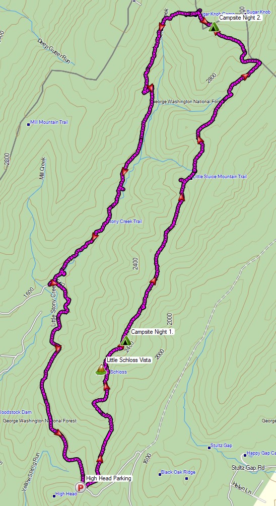
For sleep and shelter, I went with my minimalist hammock camping setup consisting of a 10 oz hammock, 5 oz tarp, and a pair 40° down quilts. The 14 mile Little Schloss Loop has a decent amount of unofficial, but preestablished campsites with some nice open areas and decently spaced trees, making it a great loop for hammocks. You can find my full backpacking gear list for this trip at the end of this post.
Water is plentiful on the Little Stony Creek side of the loop, but the ridge side of the loop that I started with is dry for the first 5 miles, so I packed in a full load of water for my first day. Finding water every couple of miles on the remaining two days was no problem at all.
Route Overview – Little Schloss Backpacking Loop – Sintax77
Join me for 3 days of Solo Backpacking, Hiking, Hammock Camping, & Wild Ponies on the Appalachian Trail in Virginia’s Grayson Highlands.
For this backpacking trip, I’ll be hiking and camping solo in a section of the Mt Rogers National Recreation Area, within the larger George Washington and Jefferson National Forest. I’ll be using a portion of the Appalachian Trail to create a 3 day, 2 night backpacking loop of around 20 miles or so. The Grayson Highlands are known for their high winds and unpredictable, rapidly changing weather, so being that I’m doing the trip in March, I’ll be packing amount of warm weather and rain resistant gear. If you’re interested in a detailed account of everything that I packed, check out my previous Winter Ultralight Backpacking Gear List blog post and video. That will give you a look at exactly what I packed for the trip.
Below is a daily rundown of the trails and campsites used for each day. Full GPS track data can be found on the Trip Data page.
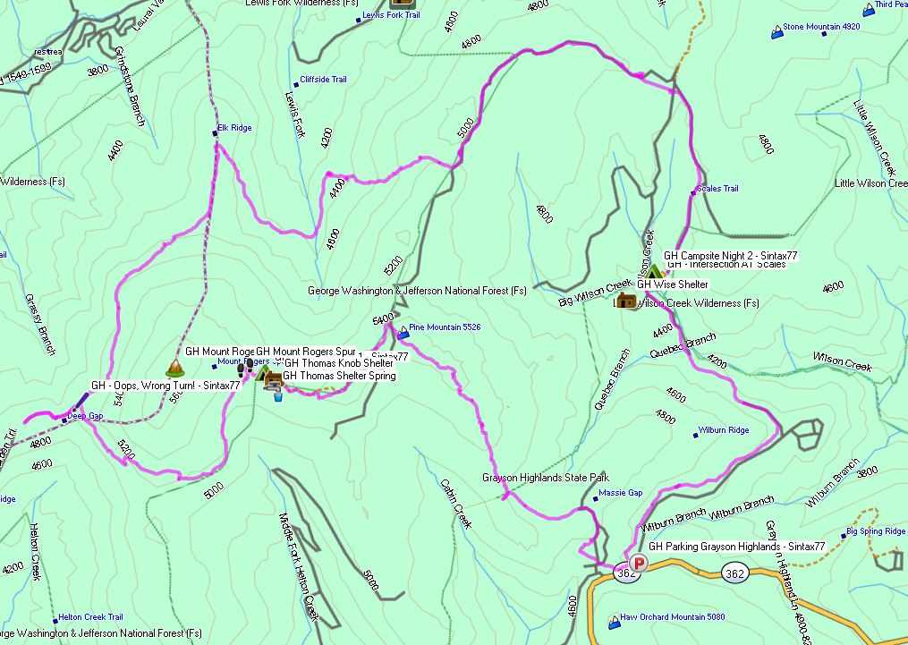
Parking Location
Grayson Highlands State Park, Overnight Backpacker’s Parking Area at the Massie Gap Parking Lot. N36° 38.012′ W81° 30.322′
Trails Used, Day 1
Depart Massie Gap Parking Lot
Rhododendron Trail
Appalachian Trail South
Wilburn Ridge Trail (it’s also possible to stay on the AT)
Rejoin the Appalachian Trail South
Setup camp about 200 yards past the Thomas Knob Shelter.
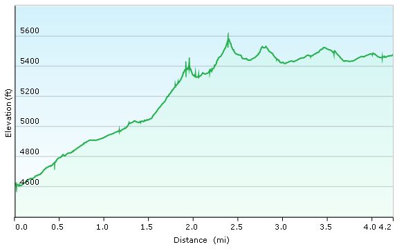
Day 1 Mileage: 4.25 miles Day 1 Elevation Gain: 2,096′
A spring is about a 100 yards down the trail behind the shelter.
Camping options for tents and hammocks are available a few hundred yards past the shelter, heading south. Tenting spots are on the ridge to the left, hammock camping opportunities are in the trees to the right.
There are also some nice campsite opportunities about a 1/4 mile or so before the shelter as well (AT north from the shelter)
Grayson Highlands Day 1 Elevation Profile – Sintax77
Trails Used, Day 2
Continue on the Appalachian Trail South
Mt Rogers Trail Towards Grindstone Campground (not to be confused with the Mt
Rogers Spur Trail which hits the summit of Mt Rogers. That trail is available shortly after leaving the campsite. I’ve heard it doesn’t have any views, but it holds the distinction as Virginia’s highest peak).
Lewis Fork Spur Trail (turn here a couple of miles before hitting the campground).
Cliffside Trail
Crest Trail
Scales Trail
Setup Camp near the intersection of Scales Trail with the Appalachian Trail
Day 2 Mileage: 11 miles Day 2 Elevation Gain: 1,320′
There are a number of hammock and tent camping opportunities on the edge of the field opposite from the AT intersection.
There is plenty water in several directions from the intersection. The particular campsite I used (tagged in my GPS data) has water right next to it within 20 yards or so.
Grayson Highlands Day 2 Elevation Profile – Sintax77
Trails Used, Day 3
Continue on the Scales Trail South (note: it is possible to continue on the AT
South and eventually make your way back to the Massie Gap parking lot as well. I chose the scales route because it is considerably quicker and I had to do a long drive home upon reaching the lot.)
Seed Orchard Trail (this wasn’t on my Nat Geo Map, but after coming out of the woods, you’ll see a sign directing you towards the AT by turning right. Instead, look left. You’ll see a water crossing with a brown Grayson Highlands State Park sign listing various rules and regs. The path along the fence over there is the Seed Orchard Trail)
Follow signs towards Hickory Ridge Campground.
Past the campground, there will be a large metal gate for a Horse Trail
Follow the Horse Trail (there doesn’t seem to be a fancier name for it)
Appalachian Spur Trail towards the Backpacker’ s Parking Lot
Return the Massie Gap Parking Lot
Day 3 Mileage: 3.5 miles Day 3 Elevation Gain: 499′
Grayson Highlands Day 1 Elevation Profile – Sintax77
Trip Grand Total Mileage: 18.75 miles Trip Grand Total Elevation Gain: 3,915′
Creating a Backpacking Loop for my upcoming winter solo camping trip in Virginia’s Grayson Highlands.
For part three of this series, I’ll be going over my specific route selection for my solo backpacking loop, including trails used, potential parking / starting points, and expected camping areas for each night. The map I chose to purchase for this trip, based on viewer feedback, was National Geographic’s Map #318 for the Mount Rogers High Country Grayson Highlands State Park region of Virginia.
A good portion of this loop will utilizing the Appalachian Trail, within the Mt Rogers National Recreation Area, as well as several other connecting trails within the Lewis Fork Wilderness and Little Wilson Creek Wilderness areas.
I will be doing continued updates throughout the whole process of planning this winter hiking trip. All the way from location selection, specific route planning, packing, food choices, getting there, doing the actual trip, and whatever else may come up in between, so check back for updates!