
Hammock Camping, Hiking & Ultralight Backpacking on the Quehanna Trail.
Yes, we’re once again camping in the rain. 🙂 For this overnight backpacking trip, I’ll be hiking a 22 mile loop in Pennsylvania’s Quehanna Wild Area, within the greater Moshannon State Forest. Luckily, I learned from my last camping trip, and packed more adequate rain gear this time.
Itching for another hammock camping trip, I decided to have some fun and go back to more of an ultralight backpacking load-out for this adventure, clocking in at roughly 8.5 pounds base weight.
My full backpacking gear list, with weights & gear links is available on this lighterpacks.com link. A truncated notable backpacking gear list can be found at the bottom of this post.
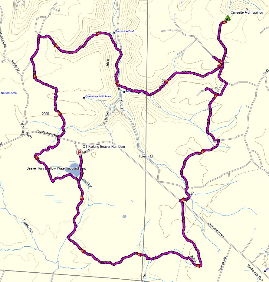
Quehanna Short Loop – Route Overview – Sintax77
No permit is required to camp in the Quehanna Wild Area or the greater Moshannon SF.
Full GPS track data, including campsites, water sources, etc, for this trip and many others can be downloaded on my Trip Data Page.
Trailhead Used:
Beaver Run Dam Wildlife Viewing Area Parking Lot
N41° 15.677′ W78° 15.494′
Beaver Run Road, Weedville, PA 15868
The Beaver Run Dam Wildlife parking area has room for a half dozen dozen or so vehicles. No parking fee or permit required. Loop begins from the parking lot side of the road, behind the information sign.
Trails Used, Day 1
- Follow the gravel road, behind the info sign.
- At the intersection, head right (northeast) on the Quehanna Trail East Cross Connector Trail (Q.T.C.C.)
- At the intersection with the Marion Brooks Trail, turn right to stay on the QTCC.
- At the gravel road (Losey Rd), turn right.
- Turn right onto the orange blazed Quehanna Trail.
- At the intersection with Red Run Road, turn left.
- Turn left at the wooden foot bridge to re-enter the woods.
- At the junction with Sanders Ski Trail, continue straight on the narrower Quehanna Trail.
- After 1 mile, turn right off of the trail, down the hill.
- Setup Camp at Arch Springs campsite
- This is a large sized camping spot with space for multiple tents or hammocks that appears to be the ruins of an old farmhouse. There’s an established fire ring in one of the old foundations. A reliable creek is nearby, so there is no need to pack in water.
Day 1 Mileage: 11.4 miles
Day 1 Gross Elevation Gain: 1,447 feet
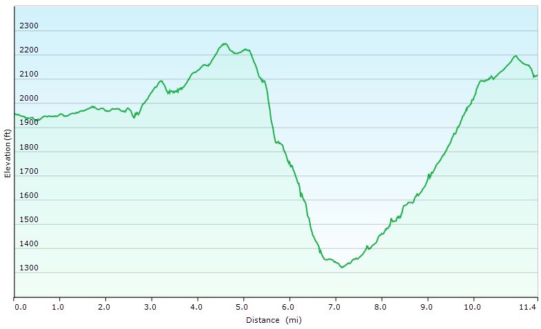
Quehanna Short Loop – Day 1 Elevation Profile – Sintax77
Trails Used, Day 2
- Backtrack out on the spur Trail.
- Head left on Sanders Ski Trail
- Turn right on the grassy forest road to stay on Sanders Ski Trail.
- Make a sharp left into the woods to continue on Sander Ski Tr.
- After two pipeline crossings, cross the gravel road and pick up the Red Run Trail.
- At the intersection post, turn right on the PSOC Link Trail.
- At the intersection, turn right on the QTCC trail.
- Return to the Beaver Run Dam parking lot.
Day 2 Mileage: 11 miles
Day 2 Gross Elevation Gain: 802 feet
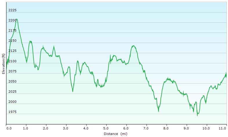
Quehanna Short Loop – Day 2 Elevation Profile – Sintax77
Grand Total Mileage: 22.4 Miles
Grand Total Gross Elevation Gain: 1,949 feet
Notable Backpacking Gear
- ULA Ohm 2.0 Backpack
- Dutchware Gear Half-Wit Hammock
- Dutchware Whoopie Hook hammock suspension w/ kevlar tree straps.
- Hammock Gear Dyneema Hex Tarp
- Hammock Gear Burrow 40 Top Quilt
- Hammock Gear Phoenix 30 Underquilt
- DIY Fancy Feast Alcohol Stove
- Light My Fire Mini Fire Steel Striker
- Toaks 750ml Titanium Pot
- Sea to Summit Long Handled Spork
- Katadyn BeFree Water Filter
- Frogg Toggs Ultra-Lite Rain Suit
- Outdoor Vitals Adventure Jacket, Loftek version
- Dutchware Folding Sit Pad
- Olight Wave Headlamp
- Benchmade Bugout Folding Knife
- Ribz Front Pack (used for camera gear)
- Mountain House Backpacking Meals


Optional Electronics carried for Weather, Navigation & Safety
- Sangean DT-400W Weather band AM/FM Radio
- Spot Gen3 GPS Messenger & SOS device
- Garmin Oregon 650 GPS unit
- Casio ProTrek PRW-2500
Camera Gear
Disclosure: A commission may be earned on some of the links on this post.