
3 Days of Hammock Camping, Hiking, & Backpacking in the Dolly Sods Wilderness.
For this 3 day, 2 night spring backpacking trip, I’ll be hiking a 23 mile loop in West Virginia’s Dolly Sods Wilderness, part of the larger Monongahela National Forest. Dolly Sods is located in the Allegheny Mountains on the highest plateau east of the Mississippi river and features some of the most varied and scenic terrain available to hikers in the Mid-Atlantic region.
For sleep and shelter system on my Dolly Sods backpacking loop, I packed in my Amok Draumr XL hammock, paired with the Amok Borg tarp and Amok Fjol XL sleeping pad. I chose this combo based on plateau’s less aggressive terrain and the extra time I expected to be lounging and relaxing at camp.
No permit is required to camp in the Dolly Sods Wilderness, but there are rules and regulations regarding backcountry camping. You can find more information on the USFS Dolly Sods website here.
Full GPS track data, including campsites, water sources, etc, for this trip and many others can be downloaded on my Trip Data Page.
Trailhead Used: Bear Rocks Trailhead, N39° 03.794′ W79° 18.197′
Public Rd 75, Davis, WV 26260
The Bear Rocks trailhead has room for many vehicles and is reached via a dirt / gravel road. The grade is not too aggressive and should be fine for most 2wd cars if driven carefully (I saw a couple when I was there). No parking fee or permit required. Loop begins behind the large info board.
Dolly Sods Printable Trail Map from the USFS
Trails Used, Day 1
- Bear Rocks Trail
- Straight (west) on Raven Ridge Trail
- Camp along the Raven Ridge Trail
- This is a large sized camping spot with space for multiple tents or hammocks, located about 100 meters after the intersection of Raven Ridge and Beaver View Trails. You’ll see a heard path on the left going into the woods. There’s an established fire ring with rocks for camp stoves, etc. pack in water.
Day 1 Mileage: 3.3 miles
Day 1 Gross Elevation Gain: 1,181 feet
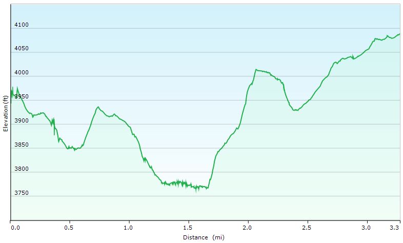
Day 1 Elevation Profile – Dolly Sods Lions Head Loop
Trails Used, Day 2
- Continue on Raven Ridge Trail
- Left (south) on Rocky Ridge Trail
- Straight (south) on Blackbird Knob Trail
- Straight (south) on Big Stonecoal Trail
- Left (southeast) at the fork on Rocky Point Trail
- Spur Trail to Lions Head
- Left (northwest) on Red Creek Trail
- Camp near Red Creek Trail at “The Forks”
- Located 1/8 of a mile after the intersection of Red Creek trail and Breathed Mountain trails, immediately after the water crossing. This area has an abundance of potential campsites, some directly along the river, others tucked farther back into the woods.
Day 2 Mileage: 12.6 miles
Day 2 Gross Elevation Gain: 1,089 feet
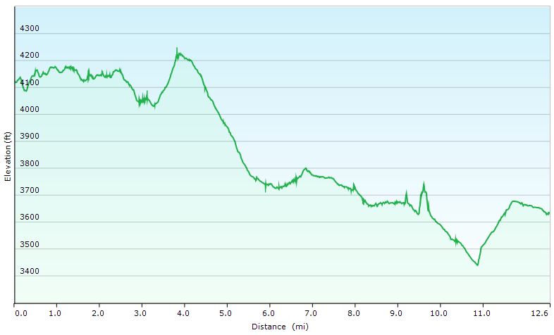
Day 2 Elevation Profile – Dolly Sods Lions Head Loop
Trails Used, Day 3
- Continue on the Red Creek Trail
- Right (east) on Blackbird Knob Trail
- Left (north) on Upper Red Creek Trail
- Right (south) on Dobbin Grade Trail (only for 1/10 mile)
- Right (north) on Raven Ridge Trail
- I highly suggest not staying on the Dobbin Grade trail. While it is a shorter route back to the parking lot, the trail traverses very boggy terrain, sometimes waist deep. Raven Ridge is much drier and more scenic as well.
- Right (east) on Bear Rocks Trail
- Return to the Bear Rocks parking area.
Day 3 Mileage: 7.1 miles
Day 3 Gross Elevation Gain: 1,303 feet
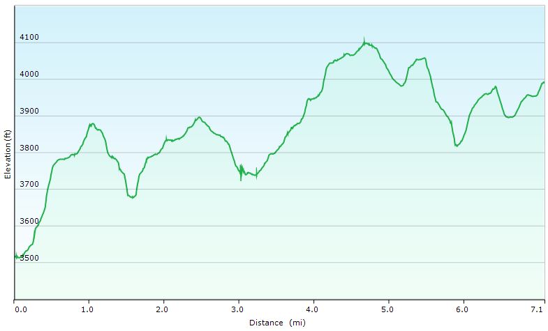
Day 3 Elevation Profile – Dolly Sods Lions Head Loop
Grand Total Mileage: 23 Miles
Grand Total Gross Elevation Gain: 3,573 feet
Notable Backpacking Gear
- Amok Draumr XL Hammock (flat laying hammock system)
- Amok Fjol XL Sleeping Pad
- Amok Borg Tarp
- ULA Ohm 2.0 Backpack
- Hammock Gear Burrow 40 Top Quilt
- DIY Fancy Feast Alcohol Stove
- Toaks 750ml Titanium Pot
- Sea to Summit Long Handled Spork
- Katadyn BeFree Water Filter
- Frogg Toggs Ultra-Lite Rain Suit
- Outdoor Vitals Adventure Jacket, Loftek version
- Adidas Terrex Swift R GTX trail runners.
- Wright Socks (I love these for blister prevention, particularly in wet conditions).
- Dutchware Folding Sit Pad
- Olight Wave LED Headlamp
- Garmin Oregon 650 GPS unit
- Casio ProTrek PRW-2500
- Mountain House Backpacking Meals
- Jiva instant coffee
- Ribz Front Pack


Disclosure: A commission may be earned on some of the links on this post.