
3 Days of Hammock Camping, Hiking & Backpacking on the White Mountains Presicat Loop.
For this 3 day, 2 night summer backpacking trip, I’ll be hiking a 30 mile backpacking loop in New Hampshire’s White Mountain National Forest. I call this the Presicat loop because it’s comprised of the Carter Range and Wildcat Range on one side, and the northern section of the Presidential Range on the other.
This route creates a grand tour of the northern White Mountains with a section of the Appalachian Trail and Mt Washington as it’s centerpiece. Along the way we’ll hit 9 major summits (NH48’s) and 8 subsidiary peaks, while racking up 15,228 feet of elevation gain on some pretty rugged trails.
For sleep and shelter I chose a minimalist ultralight hammock camping system. This allowed me to get my base weight down to 9 lb. Notable gear can be found in the gear section below. Or check out my full printable list with weights and links on LighterPack.
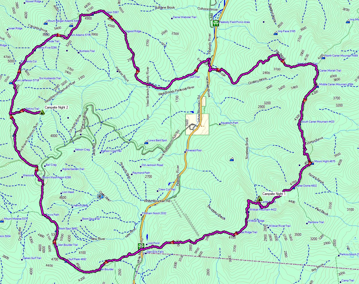
Presicat Loop Route Overview 2019 – Sintax77
No permit is required to camp in the White Mountains, but the trailhead I chose did require a self payment of $3 per day. Rules and regulations regarding backcountry camping can be found on the USFS website here.
Full GPS track data, including campsites, water sources, etc, for this trip and many others can be downloaded on my Trip Data Page.
Trailhead Used: Great Gulf Wilderness Trailhead, N44° 18.675′ W71° 13.228′
Route 16, Gorham, NH 03581
The Great Gulf Wilderness trailhead has room for plenty of vehicles and is right off of Rt 16.
Peaks Bagged (In order, bold indicates NH48 majors)
- Middle Carter Mountain
- South Carter Mountain
- Mt Hight
- Carter Dome
- Wildcat Mountain A
- Wildcat Mountain B
- Wildcat Mountain C
- Wildcat Mountain D
- Wildcat Mountain E
- Gulf Peak (Slide Peak)
- Boot Spur
- Mt Washington
- Mt Clay
- Mt Jefferson
- Adams Five
- Mt Adams
- Mt Madison
Trails Used, Day 1
- From the Parking lot, cross Rt 16 & walk south 150m to Camp Dodge Rd
- Head up Camp Dodge Rd. At the fork in the road go slightly left towards the maintenance shed. You’ll see a herd path to the left of the shed. This is the Imp Cutoff Trail.
- Imp Cutoff Trail
- Imp Trail
- North Carter Trail
- Carter-Moriah Trail (Appalachian Trail South)
- Camp along 19 Mile Brook Trail
- Head 1/8 mile down 19 Mile Brook Trail to get outside of the forest protection area surrounding Carter Notch Hut. This is not a really a typical “campsite” at all. It’s basically a random spot in some very dense and uneven terrain a couple hundred feet off of the 19 Mile Brook Trail. I used a hammock and managed to find some properly spaced trees after a bit of searching. Using a tent in this area would not be realistically possible from what I saw while scouting around. A small stream crosses the trail nearby for water. If not running, you could do a slightly longer bushwack over to the actual 19 Mile Brook (you’ll hear it running to the west).
Day 1 Mileage: 8.7 Miles miles
Day 1 Gross Elevation Gain: 4,717 feet
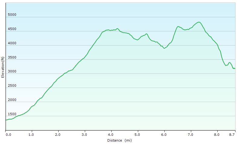
Presicat Loop Day 1 Elevation Profile – Sintax77
Trails Used, Day 2
- Backtrack on 19 Mile Brook Trail
- Wildcat Ridge Trail
- Glen Boulder Trail
- Davis Path
- Lawn Cutoff Trail
- Tuckerman Ravine Trail
- Trinity Heights Connector
- Gulfside Trail
- Mount Clay Loop Trail
- Gulfside Trail
- Sphinx Trail
- Camp near the intersection of Sphinx and Great Gulf Trail
- Room for a couple of hammocks or tents. There are several other pockets with decent camping in this general area as well. Some of them have small pre-existing fire rings. Water is readily available.
Day 2 Mileage: 11.9 Miles
Day 2 Gross Elevation Gain:6,805 feet
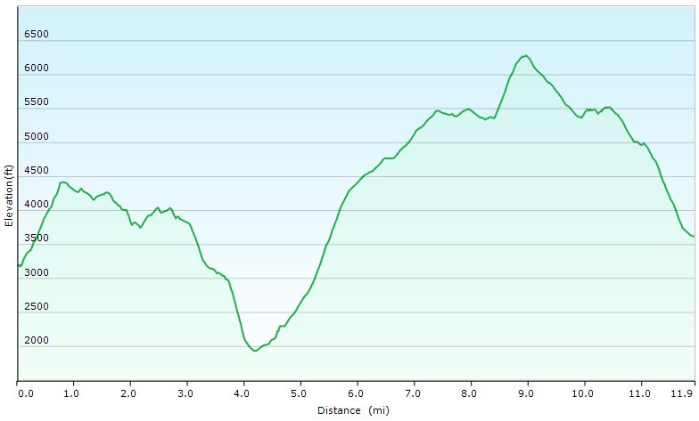
Presicat Loop Day 2 Elevation Profile – Sintax77
Trails Used, Day 3
- Backtrack on Sphinx Trail
- Gulfside Trail
- Mt Jefferson Loop Trail
- Gulfside Trail
- Osgood Trail
- Great Gulf Trail
- Return to the Great Gulf Trail parking area.
Day 3 Mileage: 9.5 miles
Day 3 Gross Elevation Gain: 3,699 feet
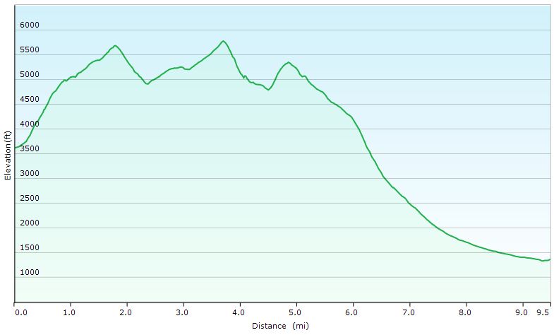
Presicat Loop Day 3 Elevation Profile – Sintax77
Grand Total Mileage: 30.1 Miles
Grand Total Gross Elevation Gain: 15,233 feet
Notable Backpacking Gear
- AMC White Mountains Map Set
- ULA Ohm 2.0 Backpack
- Dutchware Gear Half-Wit Hammock
- Dutchware Whoopie Hook hammock suspension w/ kevlar tree straps.
- Hammock Gear Dyneema Hex Tarp
- Hammock Gear Burrow 40 Top Quilt
- DIY Fancy Feast Alcohol Stove
- Light My Fire Mini Fire Steel Striker
- Toaks 750ml Titanium Pot
- Sea to Summit Long Handled Spork
- Katadyn BeFree Water Filter
- Frogg Toggs Ultra-Lite Rain Suit
- Montbell UL Down Parka
- Adidas Terrex Swift R2 GTX trail runners.
- Wright Socks
- Dutchware Folding Sit Pad
- Nitecore NU25 Headlamp
- Casio ProTrek PRW-2500
- Mountain House Backpacking Meals
- Ribz Front Pack


Filmed On
Disclosure: A commission may be earned on some of the links on this post.