
Backpacking & Solo Winter Camping during a Snow Storm on the Appalachian Trail and New York Long Path.
FTC Disclosure: This post contains affiliate links, which means I may receive a commission for purchases made through some of my links.
For this 3 day, 2 night camping trip, I decided to do a backpacking loop in New York’s Harriman State park. Despite being just a half hour north of New York City, Harriman SP offers hundreds of miles of trails, rugged mountain terrain, and rustic lean-to shelters built in the 1920’s. Covering over 47,000 acres, it stands as the second largest state park in New York and feels more like a national forest shortly after hitting the trail.
Because I did this trip in mid December with a forecast of possible snow and a temp range of just above freezing down to the teens, I figured the crowds would be at a minimum. The shelters in this area also appeared to have some great personality, so I decided to do something different – go minimal and just sleep in the shelter with a sleeping pad and a down quilt. This is a convenient and common practice for most Appalachian Trail hikers in fairer weather, but it would be a first for me in winter.
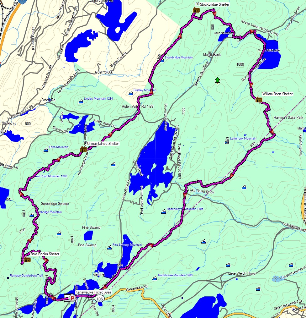
Route Overview – Harriman State Park Winter Backpacking Loop – Sintax77
No permit is required to backcountry camp in Harriman SP, but there are rules and regulations regarding backcountry camping. Most notably, you may only setup camp within 100 yards of one of the park’s lean-to shelters. You can find more information on the official Harriman State Park website here.
Full GPS track data, including campsites, water sources, etc, for this trip and many others can be downloaded on my Trip Data Page.
Trailhead Used: Kanawauke Picnic Area, N41° 14.045′ W74° 07.033′
Kanawauke Rd, Bear Mountain, NY 10911
I chose this spot to begin because the road is closed beyond this point during winter months. There are plenty of spots for parking and it was plowed while I was in the woods, which is a plus. There are also restrooms here, but they were closed for the winter when I was there.
NJTC Harriman State Park Trail Map
Trails Used, Day 1
- Road hike west on Kanawauke Rd about a half mile.
- Unnamed Forest Road (keep an eye out for the No Parking sign and small gate)
- Left (west) on Dunning Trail
- Right (north) on Ramapo Dunderberg Trail
- Lichen Trail
- New York Long Path North / Arden Surebridge Trail
- Right on Appalachian Trail North
- Left (north) on NY Long Path
- Camp at “Unmaintained Shelter” along the NY Long Path
- While listed as “unmaintained”, this is an all metal shelter that is in good condition. There’s an established fire pit directly in front of the shelter, as well as another one a few yards further away. There are plenty of nearby opportunities for tent or hammock camping as well. Water is available about 1/8 mile farther east on the New York Long Path at the crossing of Surebridge Brook.
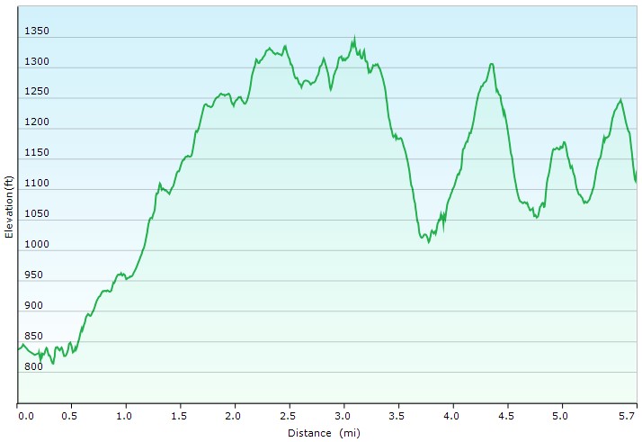
Day 1 Elevation Profile – Harriman State Park Winter Backpacking Loop – Sintax77
Day 1 Mileage: 5.7 miles
Day 1 Gross Elevation Gain: 1,581 feet
Trails Used, Day 2
- Continue on the Long Path
- Camp at Stockbridge Shelter along the NY Long Path
- Made of stone in 1928 and built into the side of the Stockbridge Mountain summit with a new metal roof two stone fireplaces. There are plenty of spots for tent or hammock camping to the rear of the shelter as well. I did not observe any viable water sources, so make sure to pack in water for your stay. I got water the next morning about 1 mile down the yellow trail at one of the streams feeding Lake Nawahunta.
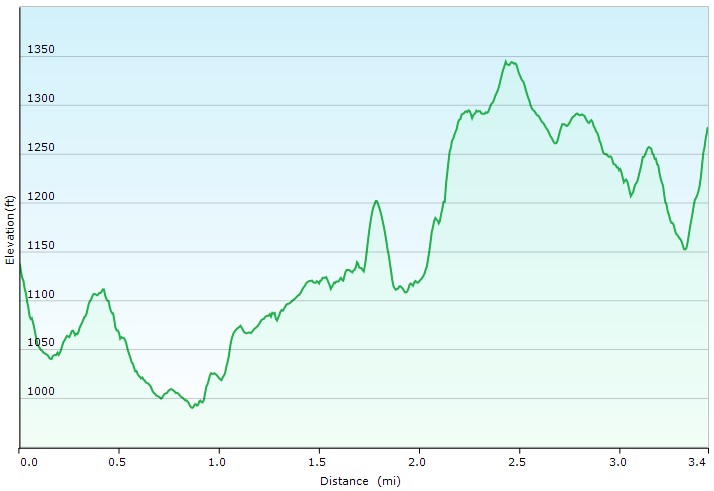
Day 2 Elevation Profile – Harriman State Park Winter Backpacking Loop – Sintax77
Day 2 Mileage: 3.4 miles
Day 2 Gross Elevation Gain: 762 feet
Trails Used, Day 3
- Backtrack south on the Long Path
- Left (east) on Menomine Trail (yellow)
- Pass by Silvermine Lake and William Brien Shelter
- Right (west) on Red Cross Trail
- Straight (southwest) on an old, unmaintained woods road.
- I did this as a shortcut to save time and elevation. I originally intended to continue on the Red Cross trail back to the Dunning Trail where I began my loop on the first day.
- Road Hike west on Seven Lakes Drive (plowed in winter)
- Return to Kanawauke Picnic Area parking lot.
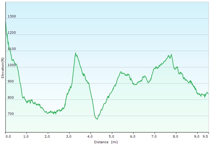
Day 3 Elevation Profile – Harriman State Park Winter Backpacking Loop – Sintax77
Day 3 Mileage: 9.5 miles
Day 3 Gross Elevation Gain: 1,466 feet
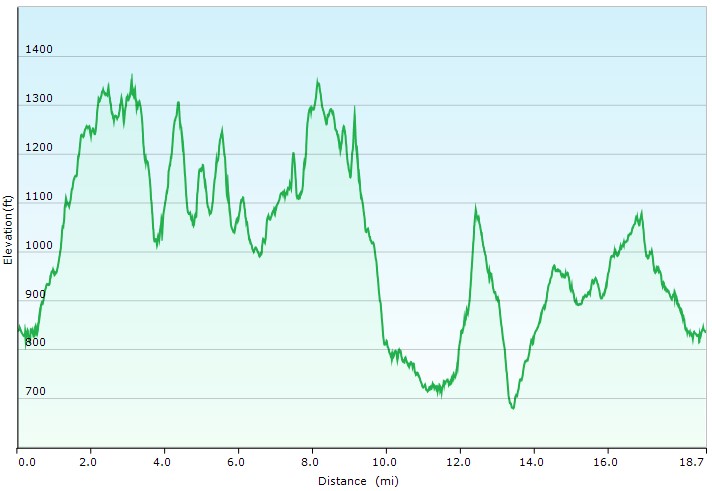
Full Route Elevation Profile – Harriman State Park Winter Backpacking Loop – Sintax77
Grand Total Mileage: 18.6 Miles
Grand Total Gross Elevation Gain: 3,809 feet
Notable Backpacking Gear
- Fjallraven Kajka 75 Backpack
- Hammock Gear Burrow 20 Top Quilt
- Amok Fjol XL Winterlight Sleeping Pad
- Dutchware UP Booties
- Toaks 750ml Titanium Pot
- Toaks 450ml Titanium Cup
- Generic Cannister Stove
- MSR Flex Skillet
- Light My Fire Mini Fire Steel Striker
- Sea to Summit Long Handled Spork
- Potable Aqua Water Purification Tablets
- Outdoor Research MicroGravity AscentShell Jacket
- Outdoor Vitals Adventure Jacket, Loftek version
- Outdoor Vitals Satu Adventure Pants
- Solomon Toundro Pro CSWP Boot
- Dutchware Folding Sit Pad
- Byer of Maine Trilite Camp Stool
- Nitecore NU25 Headlamp
- Silky F-180 Folding Saw
- Casio ProTrek F30 Smartwatch
- Benchmade Bugout EDC Folding Knife
- Peak Refuel Backpacking Meals
- Mountain House Backpacking Meals

Camera and Nav Gear used for this episode