Join Sara and I for 3 Days of Camp Cooking, Hiking, & Backpacking in the Dolly Sods Wilderness.
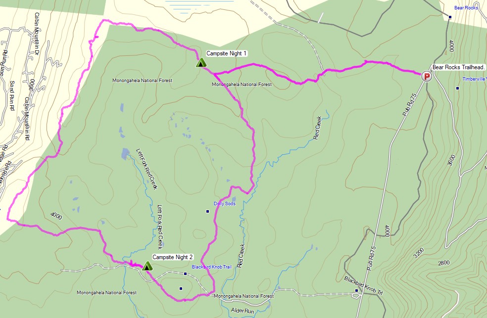
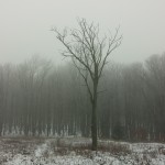
For this 3 day, 2 night backpacking trip, Sara, Denali and I decided to do some fall foliage camping in West Virginia’s Dolly Sods Wilderness, part of the larger Monongahela National Forest. Dolly Sods is located in the Allegheny Mountains on the highest plateau east of the Mississippi river and features some of the most varied and scenic terrain available to hikers in the Mid-Atlantic region.
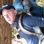
We had our dog with us on this trip, so we decided to give tent camping a go this time around to keep us all together in one spot. I also decided to totally throw lightweight backpacking out the window for this trip, so I brought along my Fjallraven Kajka 75 backpack and stuffed it to the gills with various backpacking gear, just to have a little fun and switch things up a bit (gear list at end of post). This decision was made easier by the fact that we were starting at Bear Rocks trailhead, which is already high up on the plateau with minimal elevation changes.
Campsites and great views are fairly abundant in Dolly Sods, so our general plan was to keep the mileage low and focus on a relaxed hiking pace, fun backpacking food and camp cooking. It was the perfect recipe for a laid back camping trip. Other than the whole leaking sleeping pad situation to make things more interesting…
Route Overview – Dolly Sods Fall Backpacking Loop – Sintax77
No permit is required to camp in the Dolly Sods Wilderness, but there are rules and regulations regarding backcountry camping. You can find more information on the USFS Dolly Sods website here.
3 Days of Hammock Camping, Hiking, & Backpacking in the Dolly Sods Wilderness.
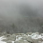
For this 3 day, 2 night spring backpacking trip, I’ll be hiking a 23 mile loop in West Virginia’s Dolly Sods Wilderness, part of the larger Monongahela National Forest. Dolly Sods is located in the Allegheny Mountains on the highest plateau east of the Mississippi river and features some of the most varied and scenic terrain available to hikers in the Mid-Atlantic region.
For sleep and shelter system on my Dolly Sods backpacking loop, I packed in my Amok Draumr XL hammock, paired with the Amok Borg tarp and Amok Fjol XL sleeping pad. I chose this combo based on plateau’s less aggressive terrain and the extra time I expected to be lounging and relaxing at camp.
No permit is required to camp in the Dolly Sods Wilderness, but there are rules and regulations regarding backcountry camping. You can find more information on the USFS Dolly Sods website here.
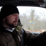
Join the crew for 3 Days of Winter Camping, Backpacking, & Campfire Cooking in Dolly Sods, West Virginia.
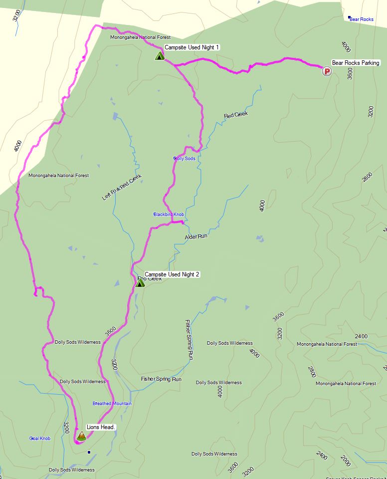
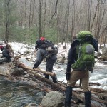
For this adventure we decided to revisit the Dolly Sods Wilderness for some early December winter camping and backpacking. Full GPS track data for this trip is available on the Trip Data page for those who like to follow along at home. Waypoints for campsites and water crossings / sources are included in the GPX file.
List of Trails Used, In order:
Day 1 Park at Red Creek Trailhead, N38° 58.372′ W79° 23.847′ Red Creek Trail TR514
Cross Red Creek at junction with Big Stonecoal Trail Big Stonecoal Trail TR513
Set up Camp at “Tj’s Moustache Camp”
Here’s how to find it: Heading north on Big Stonecoal, pass the intersection with Dunkenbarger trail on your left. Not to far ahead, Big Stonecoal will make an abrupt right turn to make a water crossing across Stonecoal Run. Instead of making the turn, continue straight along the banks, towards the woods. The camp should quickly become apparent.
Water is obviously plentiful. Firewood is probably another story, as this looks to be a popular area in warmer weather. We were equipped with hatchets and saws to process down tress, so all was well. However, during a warm weather trip without tools, I doubt we would have found much smaller stuff just laying around.
Dolly Sods Winter 2104 Day 1
Day 1 Stat Totals
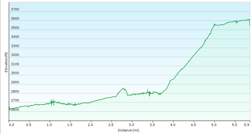
Mileage: 5.85 Miles
Gross Elevation Gain: 1,444′
Gross Elevation Loss: 453″
Campsite Altitude: 3,613′
Day 2
Backtrack a little bit to previous day’s water crossing.
Continue on Big Stonecoal Trail TR514
Arrive at the junction with Blackbird Knob Trail and Breathed Mountain Trail
Continue on Breathed Mountain Trail TR553
Turn left at junction with Red Creek Trail TR514 ** Shortly after heading out on Red Creek Trail, we found a decent supply of running water on the trail, which was much appreciated, as there would certainly be no water up towards Lion’s Head, where we intended to camp. As it was running in December, I’m thinking this may be a good option in other months as well. No guarantees though. It’s possible this was just snow melt run-off from up above. If all else fails, you could bushwack down to Red Creek, as we had actually planned to do, prior to finding this little gem on the trail. Continue on Red Creek Trail TR514 Bear to the right on Rocky Point Trail TR554
Turn abruptly right at the unofficial spur trail to Lions Head at N38° 59.243′ W79° 22.062′ ** This is not an official trail and will not be found on maps, however, it is marked with a cairn (pile of rocks). Head straight up from the cairn. There is a false summit a little ways in, but you need to actually bear to the left in order to navigate towards Lion’s Head and the eventual campsite. If you go straight towards the false summit, you’ll know it, as there is no where else to go but straight down. No worries, relax, enjoy the view and retreat towards whence you came. You’ll have to hop down some rocks, but the path should be apparent.
Head north on the Unofficial Spur Trail Towards Lion’s Head
Pause to “ooooh and ahhhh” at the sights
Continue north towards camp
Setup Camp on the ridge beyond Lion’s Head
Dolly Sods Winter 2104 Day 2
Day 2 Stat Totals
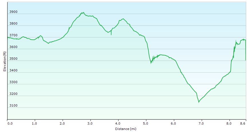
Mileage: 8.6 Miles
Gross Elevation Gain: 1,083′
Gross Elevation Loss: 1,099′
Campsite Altitude: 3,678′
Day 3 Bushwack Northwest towards Rocky Point Tr
Continue on Rocky Point Tr TR554 Turn left to head south on Big Stonecoal Trail TR514
Take Red Creek Trail TR514 Back towards Parking lot and vehicle
Find a cheeseburger!
Dolly Sods Winter 2104 Day 3
Day 3 Stat Totals
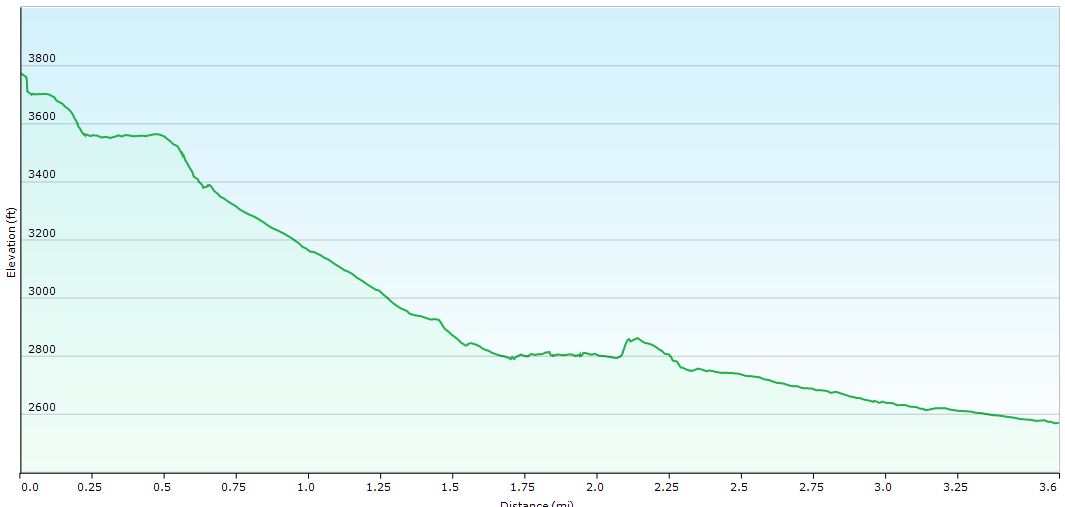
Mileage: 3.6 Miles
Gross Elevation Gain: 127′
Gross Elevation Loss: 1,332′
3 Days of Fall Camping, Hiking and Backpacking in Dolly Sods, West Virginia.
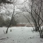
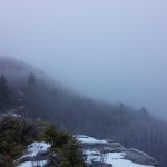
For this adventure, we’ll be exploring a very unique area of West Virginia – the Dolly Sods Wilderness Area. Being a high altitude plateau sitting at around 4,000 feet (the highest plateau east of the Mississippi river), the Sods offer a stark contrast to the surrounding West Virginian ecosystem. In fact, you may feel more like you’re in Canada than West Virginia.
Accompanied by my wife and our two close friends, this was a 3 day, 2 night backpacking adventure. Each day’s track data was recorded to individual GPX data files, available for download on the Trip Data Page for those interested.
Parking: Bear Rocks Trailhead at 39.06352, -79.30326
Trails Used in Order:
Day One (11.5 Miles):
Bear Rocks Trail 522
Raven Ridge Trail 521
Rocky Ridge Trail 524
Blackbird Knob Trail 553 (only for a very short segment)
Big Stone Coal Trail 513
Setup Camp a bit before Little Stone Coal Trail
Day 2 (9.5 Miles):
Dunkenbarger Trail 558
Little Stone Coal Trail 552
Red Creek Trail 514
(Out-n-back excursion on Breathed Mountain Trail 553)
Setup camp along Red Creek Trail between Breathed Mt and Blackbird Knob
Day 3 (6 Miles):
Red Creek Trail 514
Blackbird Knob Trail 511
Upper Red Creek Trail 509
Dobbin Grade Trail 526 – Prepare for mud and thigh-deep sinkholes!
Return to car via Bear Rocks Trail 522