Camping and Backpacking in the Adirondacks on the Tongue Mountain Range.
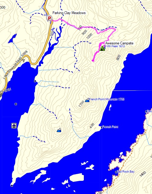
For this overnight backpacking trip, Sara, Denali and I headed up to New York for some laid back camping on the summit of Fifth Peak Mountain, overlooking Lake George. The Tongue Mountain Range is a 3 mile long peninsula, so named because it looks like a tongue jutting out into the 32 mile long Lake George. Our plan was to hike in a few miles to the top of the range and hit the first peak at the top of the peninsula to set up for an afternoon and night of relaxed camping. The next morning we would have the option to either continue along the 13 mile long Tongue Mountain loop, or hike back out the same way we came in.
We had our dog with us, so we decided to return to tent camping for this trip. We did finally upgrade our previous budget tent to a four person (or 2 plus a dog) Marmot Limelight 4p tent though. And as I usually do for trips with my wife and dog, I packed in a massive backpack full of comfort camping gear and fun camp food. A more detailed gear list can be found at the bottom of this post.
Thank you to Anker for sponsoring this video. My viewers can get $100 off the Anker Powerhouse II 800 by using this link on Amazon or direct from Anker.
There is no permit required for backcountry camping on the Tongue Mountain Range, but there are certain rules and regulations. You get find more info on the official NY DEC website here.
No permit is required to camp in the George Washington National forest, but there are rules and regulations regarding backcountry camping. You can find more information on the George Washington & Jefferson National Forest website here.
Section Hiking on the Vermont Long Trail – Appalachian Gap to Lincoln Gap.
For this backpacking trip, my dog Denali and I will be doing a 2 day, 1 night camping trip in Northern Vermont. The specific area we’ll be camping near is called the Stark’s Nest, which lies on a section of the Long Trail between Appalachian Gap and Lincoln Gap, about 40 minutes west of Montpelier, VT.
The Vermont Long Trail is a 273 mile, long distance hiking trail that runs the entire length of Vermont, from the sothern border with Massachusetts all the way up to the Canadian border to the north. The first hundred miles or so in the south coincide with the Appalachian Trail as well. I’ll be backpacking and camping just a short taste of the Long Trail – a roughly 8 mile section in the North Country of Vermont on a combination of private land and Vermont’s Green Mountain National Forest.
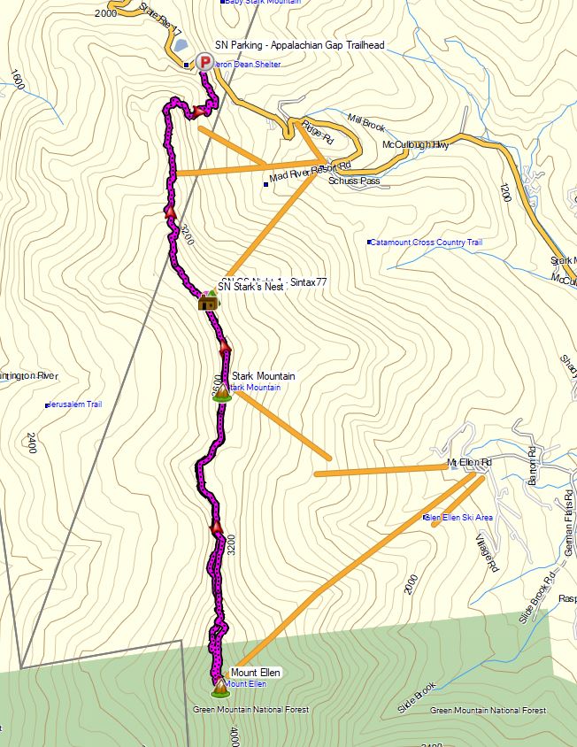
Starks Nest Hike – Route Overview – Sintax77
GPS Data for this trip and many others can be found on my Trip Data Page. Includes full track data for each day, and way-points for campsites used, water sources, etc.
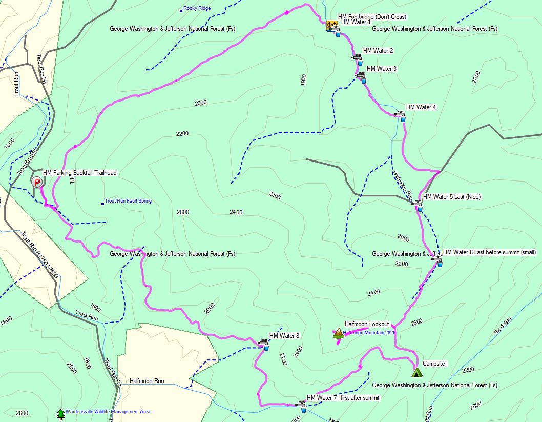
Trailhead Used: Appalachian Gap Trailhead Parking Area – 44°12’39.7″N 72°55’53.5″W This is a large, paved parking area just off of Vermont SR17. The Vermont Long Trail South (which I took in the video) can be found on the opposite side of the road. The Long Trail North (which I didn’t take) is located right in the corner of the lot, by the guard rail.
Trails Used & Itinerary, Day 1
Park at the Appalachian Gap Trailhead Parking Area
Take the Vermont Long Trail South (located on the other side of the road. Look for the white blaze
Arrive at Stark’s Nest warming hut and grab some water from the rain barrel. Note: Stark’s Nest is a ski warming hut. During the winter, this is a hut used to take a break and warm up in between ski runs at Mad River Glen Ski Resort. While this is private property, it is kept open and available to hikers year round as a place to take a break, or camp for the night while hiking the Vermont Long Trail. There is a rain barrel out front that makes for an excellent water source. It’s essentially a fully enclosed cabin that makes it a great option for riding out storms and bad weather. There is a composting outhouse nearby, across from the cabin in the woods opposite the cabin.
Set up camp a little ways down the ski slope near Stark’s Nest
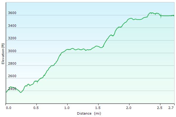
Starks Nest Hike Day 1 – Elevation Profile
Day 1 Mileage: 3 miles Day 1 Gross Elevation Gain: 1,501′ Day 1 Gross Elevation Descent: 283′
Trails Used, Itinerary Day 2
Leave camp and head back uphill to the Stark’s Nest.
Continue south on the Vermont Long Trail.
End at the ski lift area on Mt Ellen for a break and some views.
Backtrack out the way you came, via the Long Trail North.
Arrive back at the Stark’s Nest.
Breakdown camp, pack up and replenish water supplies.
Backtrack out on the Vermont Long Trail North.
Arrive back at the Appalachian Gap Trailhead Parking area.
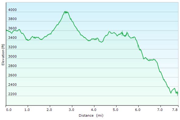
Starks Nest Hike Day 2 – Elevation Profile
Day 2 Mileage: 8 miles (5 round-trip for Mt Ellen, 3 for the hike out from Stark’s Nest) Day 2 Gross Elevation Gain: 1,566′ Day 2 Gross Elevation Descent: 2,919′
Join my dog Denali and I for some Hiking, Backpacking, and Hammock Camping in the Seneca Creek Backcountry.
For this hiking adventure, my pup and I will be visiting the Spruce Knob-Seneca Creek National Recreation area, within West Virginia’s greater Monongahela National Forest. Our route will be a “lollipop”style hike – meaning we’ll use an “out and back” section of trail from the Spruce Knob trailhead parking area to connect with a series of other trails that form a loop. After completing the loop portion of the hike, we’ll backtrack out using the same section of trail from day one.
The Spruce Knob-Seneca Creek Backcountry offers around 60 miles of trails (marked with blue blazes) with an elevation range of 3,000 to 4,800 feet above sea level. The beginning of this particular loop is actually the highest point in all of West Virginia – Spruce Knob – standing at and elevation of 4,861 feet. Below is a list of trails for each day, along with stats for elevation gain and mileage.
Trailhead Parking: Spruce Knob Parking area (right by the observation tower).
Parking Notes: No parking fees or overnight permits are required. There are restrooms and bear-proof trash bins available for use.
GPS Track Data for this trip can be found on my Trip Data Page.
Trails used, Day 1
Huckleberry Trail
Hornton Trail (just for a short bit)
Judy Springs Trail
Seneca Creek Trail
Hammock Camp along Seneca Creek.
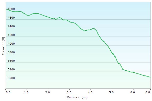
Day 1 – Seneca Creek Loop elevation Profile – Sintax77
Day 1 Mileage: 6.5 miles Day 1 Gross Elevation Gain: 221 feet (pretty much down hill all day)
Trails used, Day 2
Seneca Creek Trail
High Meadows Trail
Lumberjack Trail
Join back up with Huckleberry Trail
Arrive back at Spruce Knob Parking Lot
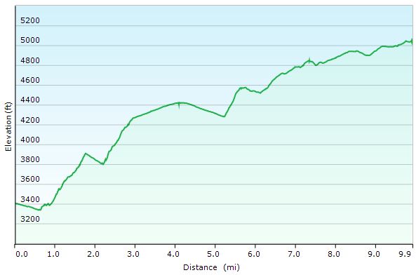
Day 2 – Seneca Creek Loop elevation Profile – Sintax77
Day 2 Mileage: 10 miles Day 2 Gross Elevation Gain: 2,173 feet (pretty much up hill all day)
Sara finally does a cabin trip! Oh, and her car gets stuck in the snow. So we drag all our stuff up the mountain instead of driving. 😉
I’m not sure if this exactly what Sara was picturing as her first trip to our hunting cabin, but nonetheless it made for some great memories. Join us for 3 days of wood stove stoking, PA game lands hiking, BBQ grilling, cabin chores, and just plain relaxing in the woods.


 Collapsible Dish
 – Freeze Dried Dog Treats for Hiking


 (don’t trust your dog with the cheap key chain grade ones).