Winter Camping and Finding a Plane Crash – Mt Success DC-3

Backpacking & Solo Winter Camping in search of a 1954 commercial airline crash near the summit of Mt Success in the White Mountains.

FTC Disclosure: This post contains affiliate links, which means I may receive a commission for purchases made through some of my links.

For this 3 day, 2 night camping trip, I headed up to a lesser traveled corner of New Hampshire’s White Mountain National Forest for some snowshoeing, camp cooking, and bit of New England aviation history.

My goal for this adventure was to find the resting place of Northeast Airlines Flight 792, which crashed on approach to Berlin Municipal Airport during inclement weather on November 30th, 1954. It made contact in the dense trees near the summit of Mt Success at an elevation of 3,390 feet.  More information on the details of Flight 792 and the circumstances of it’s survivors can be found in this copy of the official Accident Investigation Report

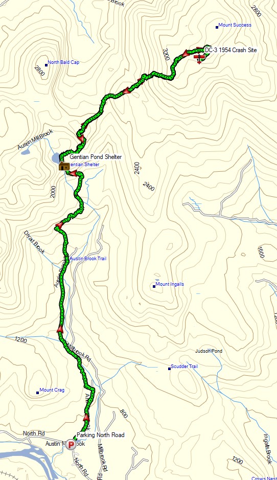
The 6.5 mile hike to get there would require a gross elevation gain of roughly 3,700 feet on potentially unbroken trail in deep snow.  The final portion of the hike would be an unofficial bushwhack through dense trees and snow.  For this reason, I chose to break up the approach up by setting up camp at roughly the halfway point along Gentian Pond and the nearby lean-to shelter with sweeping views of the Carter-Moriah mountain range.  After camping for the night, I would head up to the top of Mt Success, the first peak of the Mahoosuc Range and the Appalachian Trail’s gateway to Maine. After a few miles and a couple thousand feet of ascent with my trusty snowshoes, I would leave the trail behind in search of the DC-3.

Mt Success DC-3 Winter Backpacking Trip – Route Overview

No permit is required to backcountry camp in the White Mountains, but some locations do require a daily, weekly, or annual pass.  The parking area for this trip did not require a parking fee as of January 2021.

Full GPS track data, including campsites, water sources, etc, for this trip and many others can be downloaded on my Trip Data Page.

Trailhead Used: Austin Brook Trailhead on North Road,  44°24’45.1″N 71°04’05.4″W
North Rd, Shelburne, NH 03581

Continue reading

Alone in the Pemi Wilderness – Winter Camping Adventure

3 Days of Winter Hammock Camping, Backpacking, & Snowshoeing in the White Mountains Pemigewasset Wilderness.

This trip was sponsored by Backcountry, who gave me the opportunity to upgrade three of my essential winter backpacking gear items for this trip. A gear list can be found at the end of this post.

FTC Disclosure: This post contains affiliate links, which means I may receive a commission for purchases made through my links, at no additional cost to you. Individual gear selections were made by me and all opinions are my own.

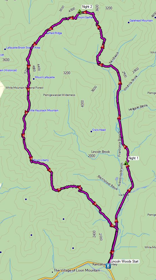
For this 3 day, 2 night spring winter camping trip, I’ll be hiking what amounts to a sort of “Half Pemi Loop”.  While a full pemi loop consists of the Franconia Ridge on one side and the Bondcliff ridge on the other, my plan was to use the lesser used Franconia Brook trail to go straight up the middle of the loop.  This would take me above treeline right near the summit of Mt Garfield, with the option to take either the Franconia Ridge to the west, or the Bondcliffs to the east in order to return to the Lincoln Woods visitor center where I had left my Jeep.

Even during “regular” backpacking season, the White Mountains are a quite challenging area to hike due to notoriously rapid changing weather conditions and steep, rugged terrain.  Add in some deep snow, ice, rain, high winds and a freeze / thaw temp range of 40° to 16° F, and things can get even more fun.  I had a great time, but it was probably the toughest solo winter backpacking trip I’ve ever done.

Winter Half Pemi Route Oveview – Sintax77

No permit is required to camp in the White Mountains NF, but there are rules and regulations regarding backcountry camping.  You can find more information on the USFS White Mountains website here. Some parking areas, such as the one I used for this trip, do require a vehicle fee of $5 per day.

Full GPS track data, including campsites, water sources, etc, for this trip and many others can be downloaded on my Trip Data Page.

Continue reading