
Come along for 5 days of Hiking, Camping & Backpacking in Southern Utah’s Zion National Park.
For this adventure, I’ll be spending 5 days exploring Zion National Park with my friends Derrick, Dave, and Tayson from Outdoor Vitals and Randy from Outdoor.Detour on Instagram. We’ll be doing 3 different backpacking / camping trips: A backcountry West Rim Backpacking Trip, Exploring & hiking the Frontcountry Zion National Park area while car camping in Springdale, Utah, and a backcountry camping trip on a top-down Narrows hike, ending at the Zion visitor’s center back in Springdale.
Note: All backcountry camping in Zion requires a permit. For details, visit the Zion NPS website.
Limited time offer from Outdoor Vitals – Get the camping pillow I’m using in this video for FREE by clicking here.
Objective #1: Backcountry camp on Zion Canyon’s West Rim
Trailhead Used: West Rim Trailhead, Near Lava Point Overlook.
GPS coordinates N37° 22.899′ W113° 01.370′
West Rim Itinerary, Day 1
- Park at the West Rim Trailhead parking area on the dirt service road near Lava Point.
This is a gravel lot with parking for at least a half dozen cars or so. It’s about a 40 minute drive from Springdale, Utah. The latter part of the drive is on a dirt road, but non 4wd vehicles should be fine with a bit of care. - Head south on the West Rim Trail
- Setup Camp at West Rim campsite #4 GPS N37° 17.144′ W112° 59.030′
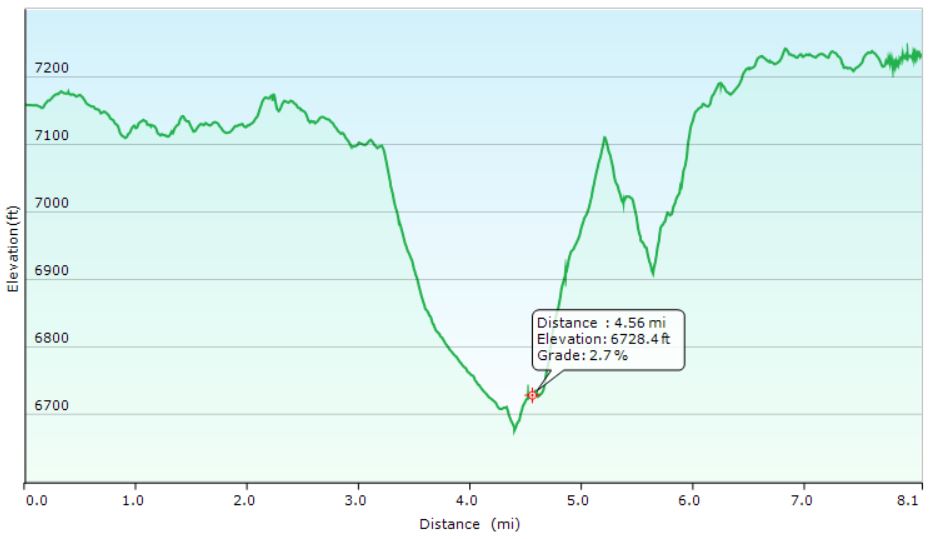
West Rim Hike Elevation Profile- Sintax77
West Rim Hike-In Mileage: 8 miles
West Rim Hike-In Gross Elevation Gain: 1,073
West Rim Itinerary, Day 2
- Backtrack north on the West Rim Trail
- Return to the trailhead parking lot near Lava Point.
- Ghost town pit-stop in Grafton, Utah
- Continue on to Springdale, Utah.
- Check into the Quality Inn campground in Springdale, within walking distance of the Zion visitor center and park entrance.
- Have some tacos at the Whiptail Grill, right next door to the campground. I got the “Fire Asada” tacos and they were great. If you like spicy food that’s actually spicy, I would highly recommend the Whiptail Grill. Heck, even if you don’t like spicy stuff – they have milder options, plus a fun & unique casual atmosphere as well. Oh, and the view is amazing too 🙂
Objective #2: Explore Zion National Park’s Frontcountry & Springdale, Utah.
Zion Frontcountry / Springdale Itinerary. Day 1
- Wake up at the car campground in Springdale,
- Take the free Zion shuttle, or a short walk north to the Zion National Park visitor center / entrance.
- Take the Zion NP bus from the visitor center to Big Bend.
- From the Big Bend bus stop, take the trail south along the Virgin River to Weeping Rock.
- Road hike a bit along the Mount Carmel Highway to soak in the sights.
- Hop another free Zion bus back towards the Springdale Visitor Center.
- Explore Springdale, eat some ice cream at the Zion Candy Company on Zion Park Blvd.
Objective #3: Hike and Backcountry Camp the Narrows, from the Top Down.
Trailhead Used: Chamberlain’s Ranch Trailhead (aka Zion Narrows Upper Trailhead), Duck Creek Village, UT
GPS Coordinates N37° 23.121′ W112° 50.339′
Note: This was an end-to-end hike that required us to park a second vehicle at the Zion visitor center in Springdale to use as a shuttle back to the starting point. The drive from the visitor center back to the Chamberlain’s Ranch Trailhead is around 80 minutes.
Zion NP – The Narrows, Top-down Hike Itinerary, Day 1
- Park at the Narrows Upper Trailhead in Duck Creek, UT.
- Head southwest on the trail, which is actually dirt road, closed off to vehicles, for the first 3 miles.
- Continue to follow the trail along the Virgin River, through the Narrows.
- This trail is very easy to follow, as it is literally the river. A majority of the time will be spent walking in the river bed in ankle deep to knee deep water depending on conditions, depending on current water-flow conditions.
- Note for reference: The ccf reading during our trip was roughly 40 CCF. Anything under 50 ccf is considered to be relatively ideal. Above 100 cfs, conditions can be difficult and hazardous. At 130 ccf, top-down narrows hikes will be closed. At 150 ccf, bottom up Narrows hikes will be closed. During a flash flood, flows can exceed 1000 cfs.
- Setup camp at the Narrows campsite #12. N37° 19.982′ W112° 57.373′
Zion NP – The Narrows, Top-down Hike Itinerary, Day 2
- Break camp and continue south along the Virgin River.
- Exit the trail and catch the free Zion bus at the Temple of Sinawava shuttle stop.
- Return to the Zion NP Springdale Visitor Center
- Drive back to retrieve starting vehicle (~80 minute drive)
Notable Gear Seen:
- Outdoor Vitals Ultralight Hammock w/ Whoopie Sling Suspension
- Outdoor Vitals 30° Underquilt
- Outdoor Vitals 30° Topquilt
- Outdoor Vitals Pillow
- Outdoor Vitals Tarp
- Outdoor Vitals Hammock Bugnet
- Outdoor Vitals Dominion 2.5p Tent
- Outdoor Vitals 1p Tent
- Outdoor Vitals Sleeping pad, un-insulated
- Outdoor Vitals Sleeping pad, insulated
- Garmin In Reach Emergency GPS Locator
- Spot Messenger Emergency GPS Locator