
4 Days of Solo Backpacking, Hiking & Camping in the Black Hills of South Dakota.
For this late summer backpacking adventure, I decided check out two places I had never been to before – the Mount Rushmore Memorial and the adjacent Black Elk Wilderness within the Black Hills National Forest.
I was surprised to discover that there’s actually a trailhead right at the base of Mount Rushmore, so it seemed like to perfect opportunity to create a unique backpacking experience.
Speaking of those looming presidential faces, I should make an important point – While the Mount Rushmore statue, parking lot and visitor center, etc. is a National Memorial (managed by the National Park Service), the surrounding area is National Forest, so dispersed camping is all good!
With that in mind, I mapped out a roughly 30 mile hiking loop using the available trails, packed my tent, sleeping pad and some backpacking food into my backpack, and got a ride from my wife to the trailhead.
Due to the close proximity to the National Monument, the trailhead parking lot is closed off to overnight parking. This probably makes this a lesser used starting point for backpackers, but it’s well worth it if you have someone nice enough to drop you off and pick you up after a few days of camping in the Black Elk Wilderness.
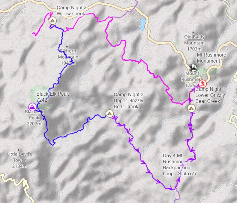
Route Overview – Mt Rushmore Black Hills Backpacking Loop – Sintax77
Full GPS track data, including campsites, water sources, etc, for this trip and many others can be downloaded on my Trip Data Page.
Trailhead Used: Mount Rushmore Blackberry Trailhead, 43°52’24.5″N 103°27’15.9″W
Mount Rushmore, SD 57751
The closest safe & free spot to do a drop-off or pickup near the trailhead is a small pull-off lot 1/8th of a mile west on Route 244. Alternatively, you could pay $10 to temporarily park in the Mt Rushmore lot (overnight parking is not permitted).
Trails Used, Day 1
- Begin at the Mt Rushmore Blackberry Trailhead
- Blackberry Trail
- Left (west) on Centennial Trail
- Setup Camp along Centennial Trail.
- This is a nice campsite tucked off the trail with water readily available from nearby Grizzly Bear Creek. There are two flat grassy clearing separated by some trees that make for easy camping. Note: campfires are not permitted in the Black Elk Wilderness.
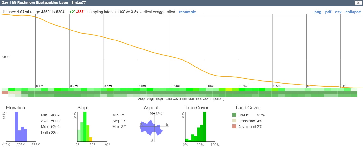
Day 1 Elevation Profile – Mount Rushmore Black Hills Backpacking – Sintax77
Day 1 Mileage: 1.07 Miles
Day 1 Elevation Gross Gain: 2′
Day 1 Elevation Gross Descent: 337′
Trails Used, Day 2
- Backtrack on Centennial Trail
- At the intersection, continue Centennial Trail
- Left (North) on Harney Trail
- Setup camp along Harney Trail.
- This is a small spot tucked back in the boulders along the trail. This is a dry campsite. Water is available 1 mile downhill on the Willow Creek Trail. My stats below include the roundtrip to go get water after setting up camp.
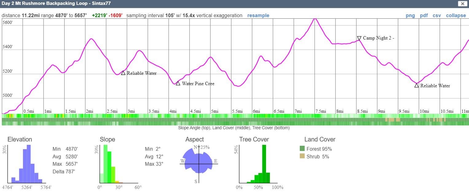
Day 2 Elevation Profile – Mount Rushmore Black Hills Backpacking – Sintax77
Day 2 Mileage: 11.22 Miles
Day 2 Gross Elevation Gain: 2,219′
Day 2 Gross Descent: ‘1,609
Trails Used, Day 3
- Backtrack on Harney Trail
- At the intersection, continue on Harney Trail
- Spur Trail to Black Elk Peak and back
- Formerly Harney Peak, with an elevation of 7,244 feet, this is the tallest peak in South Dakota and the Midwest.
- Norbeck Trail
- Grizzly Bear Creek Trail
- Setup camp along Grizzly Bear Creek.
- This is an awesome campsite with expansive views and opportunities for a couple tents or hammocks. Water is available from small stream hidden in the tall grass along the trail a short distance before arriving at the campsite. If the spot is occupied, there’s a heard path at the back of the site heading up hill to more options.
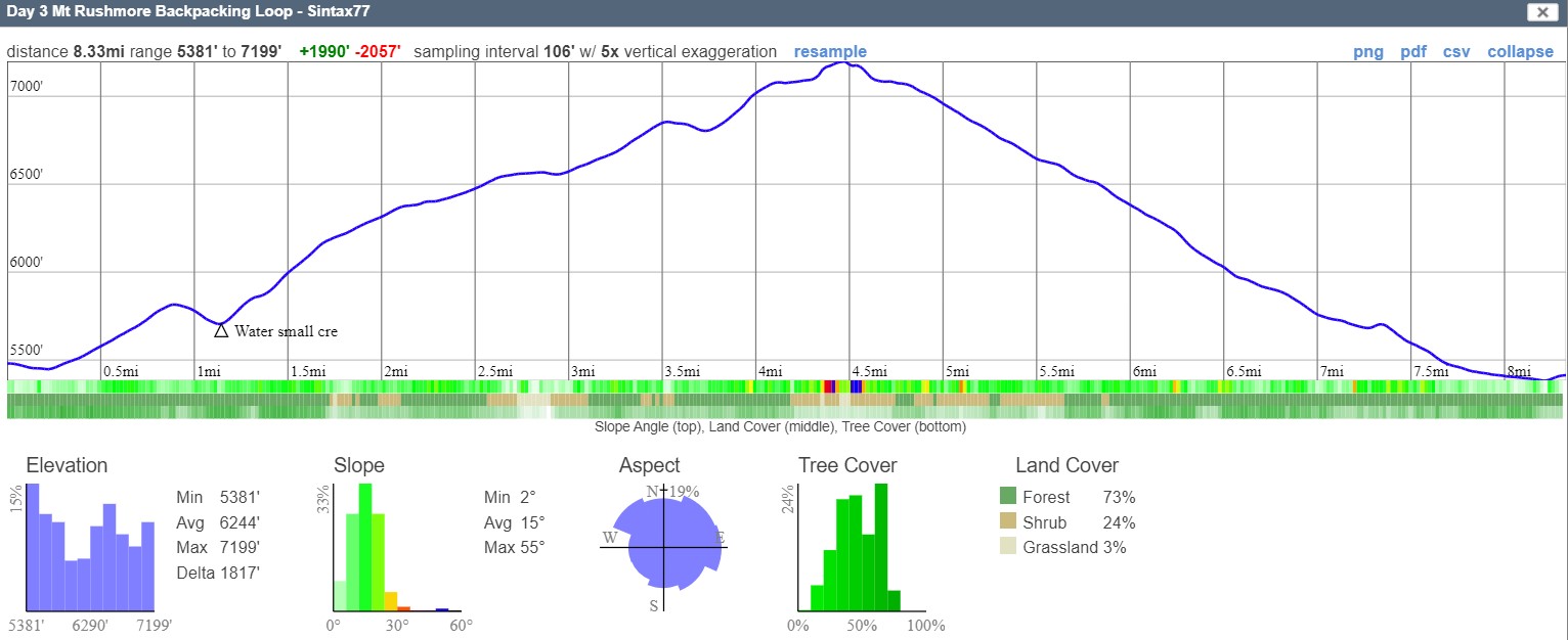
Day 3 Elevation Profile – Mount Rushmore Black Hills Backpacking – Sintax77
Day 3 Mileage: 8.33 Miles
Day 3 Gross Elevation Gain: 1,990′
Day 3 Gross Descent: 2,057′
Trails Used, Day 4
- Continue on Grizzly Bear Creek Trail
- Centennial Trail
- Blackberry Trail
- Return to Mt Rushmore Blackberry Trailhead
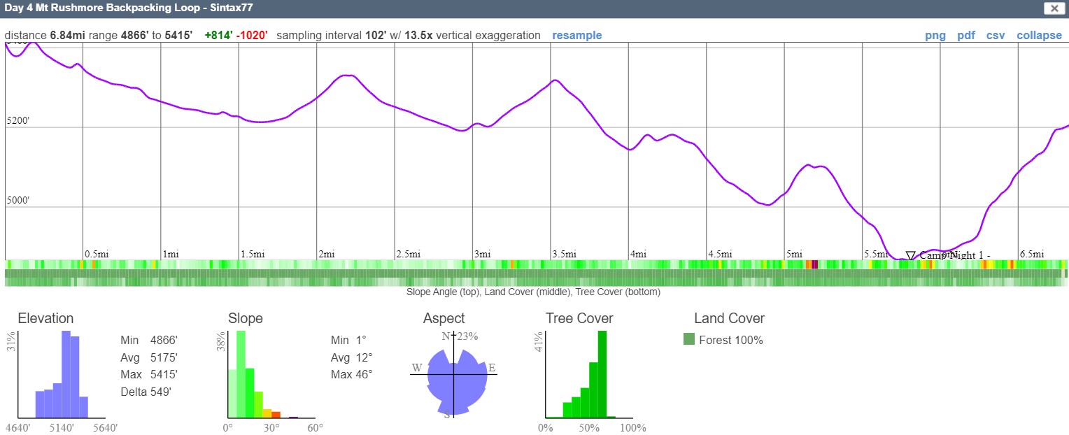
Day 4 Elevation Profile – Mount Rushmore Black Hills Backpacking – Sintax77
Day 4 Mileage: 6.84 Miles
Day 4 Gross Elevation Gain: 814′
Day 4 Gross Descent: 1,020′
Grand Total Mileage: 27.46 Miles
Grand Total Elevation Gain: 5,025′