
3 days of Backpacking & Hammock Camping along Cranberry Lake in the Adirondacks
FTC Disclosure: This post contains affiliate links, which means I may receive a commission for purchases made through some of my links.
For this adventure, I decided to do a fall backpacking trip with some higher trail mileage than I’ve been doing lately. Nestled in New York’s Five Pond Wilderness, the Cranberry Lake 50 is a fifty mile loop hike that circumnavigates it’s namesake, and passes by many smaller ponds along the way as well. Most of these smaller ponds have campsites or even a lean-to shelter nearby, which is quite nice.
The CL50 is not really an individual trail, but a collection of trail sections from 12 other trails is the area. The route is well blazed with blue CL50 plastic discs nailed to trees along the way. The trails used to make up the CL50 are blazed with similar yellow trail discs, so you will often see both blazes simultaneously.
The Cranberry Lake 50 goes directly through two towns – Wanakena, where I started, and the town of Cranberry Lake. There’s only about 10 trail miles between them, so neither really poses much logistical value for resupplying, but they are nice towns to stroll through.
I chose to do the loop counter clockwise from Wanakena because the last 10 miles traverse some muddy wet sections due to beaver dams, so I figured it would be best to save that for the last afternoon.
I typically like to hike my backpacking trips on a 3 day, 2 night timeline, so that meant my daily trail mileage had to be around 17 miles or so during the shortened daylight hours of October. On the upside, this hike is primarily along the perimeter of a lake, with minimal elevation changes, but did I mention that I hadn’t done a high mileage trip in a while? Yeah, the headlamp got a good amount of usage on this one. Let the night hiking begin…
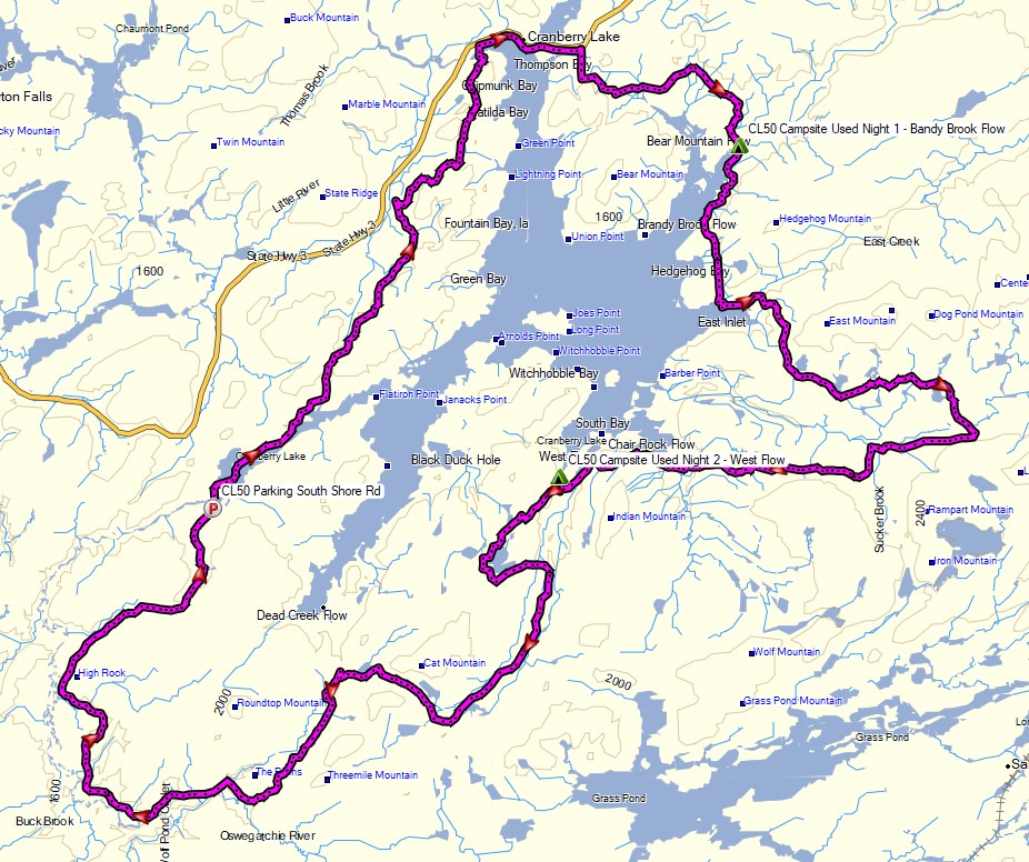
Route Overview – Cranberry Lake 50 Backpacking Loop – Sintax77
Trailhead Used:
Cranberry Lake 50 Trailhead South Shore Rd
44°07’54.7″N 74°55’19.0″W
20 South Shore Rd, Wanakena, NY 13695
This is an easily accessible dirt lot next to the tennis court on South Shore Rd with room for a half dozen cars or so. Trail begins on the other side of the road and crosses a footbridge into town.
Full GPS track data, including campsites, etc, for this trip and many others can be downloaded on my Trip Data Page.
Thank you to Fishing Clash for sponsoring this trip video. My viewers can download it for free using this link, and new users can get a special reward pack of loot by entering the code FishWithSintax77 from within the game’s gift code page.
The mileages listed below are actual trail mileage. My mileage in the video was slightly higher due to my meanderings and the occasional wrong turn.
Trails Used, Day 1
- Cross the footbridge on the opposite side of the road
- Follow the CL50 markers through town of Wanakena for 2 miles
- Peavine Swamp Trail
- West Connector Trail
- Follow the CL50 markers through the town of Cranberry Lake for 2 miles
- East Connector Trail
- Campground Trail
- Bandy Brook Flow Trail
- Setup camp along Bandy Brook Flow Trail
- This was a nice clear area right at the intersection with Burntbridge Pond Trail with room for multiple tents or hammocks. I didn’t notice any established firepits in the area, but water is available at the nearby Bandy Brook Flow.
Day 1 Mileage: 14.5 miles
Day 1 Gross Elevation Gain: 1,236 feet
Day 1 Gross Descent: 1,232 feet
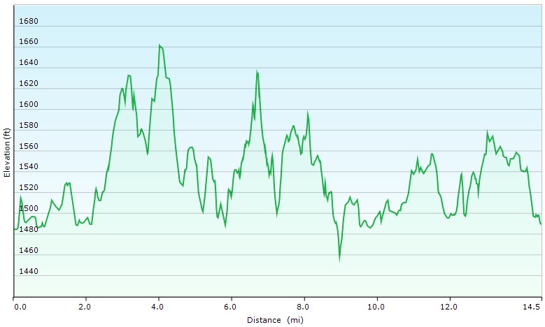
Day 1 Elevation Profile – Cranberry Lake 50 Backpacking Loop – Sintax77
Trails Used, Day 2
- Bandy Brook Flow Trail
- Dog Pond Trail (with a meal break on the shore of East Inlet)
- Otter Brook Trail
- South Bay Trail
- Six Mile Creek Trail
- Camp along Six Mile Creek Trail
- I left the CL50 at the intersection with Olmstead Pond Trail and camped about 300 yards down SMC trail in an established spot near West Flow with a firepit and a reliable piped spring. I didn’t notice while setting up in the dark, but there was another spot farther down the trail that was right on the water.
Day 2 Mileage: 15.5 miles
Day 2 Gross Elevation Gain: 2,327 feet
Day 2 Gross Descent: 2,317 feet
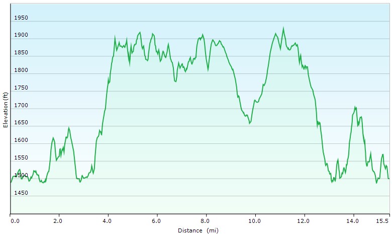
Day 2 Elevation Profile – Cranberry Lake 50 Backpacking Loop – Sintax77
Trails Used, Day 3
- Backtrack on Six Mile Creek Trail
- Olmstead Pond Trail
- Six Mile Creek Trail
- Cowhorn Junction Trail
- New Plains Trail
- High Falls Loop Trail
- Return to South Shore Rd
Day 3 Mileage: 19.2 miles
Day 3 Gross Elevation Gain: 1,394 feet
Day 3 Gross Descent: 1,408 feet
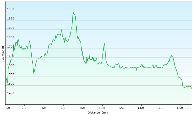
Day 3 Elevation Profile – Cranberry Lake 50 Backpacking Loop – Sintax77
Grand Total Mileage: 49.2 miles
Grand Total Gross Elevation Gain: 4,957
My base weight for this trip was a little over 7 pounds. It was similar to this list on LighterPack, but I swapped the rain parka for a heavier button-up shirt.
Notable Backpacking Gear
- ULA Ohm 2.0 Backpack
- Dutchware Pack Cover
- Dutchware Gear Half-Wit Hammock
- Dutchware Whoopie Hook hammock suspension w/ kevlar tree straps.
- Hammock Gear Burrow 40 Top Quilt
- Hammock Gear Phoenix 30 Underquilt
- Hammock Gear Dyneema Hex Tarp
- DIY Cat Can Alcohol Stove
- Vargo Windscreen
- Light My Fire Mini Fire Steel Striker
- Toaks 750ml Titanium Pot
- Sea to Summit Long Handled Spork
- Potable Aqua Water Purification Tablets with PA Plus
- RevolutionRace Men’s GP Pants
- RevolutionRace Campfire Shirt
- La Sportiva Wildcat Trail Running Shoes
- Nitecore NU25 Headlamp
- Benchmade Bugout EDC Folding Knife
- Casio ProTrek F-30 Smartwatch
- Packit Gourmet Backpacking Meals

Camera and Nav Gear used for this episode