
Backpacking, Hiking & Shelter Camping in Vermont’s Lye Brook Wilderness.
FTC Disclosure: This post contains affiliate links, which means I may receive a commission for purchases made through some of my links.
For this late November backpacking trip, I decided to hike a 3 day, 23 mile loop in the Green Mountains with 2 nights of camping near Stratton Pond and Bourn Pond. By setting up a base camp at Stratton Pond, I would also have the opportunity to do an out and back hike on the second day to visit the fire tower that sits atop Stratton Mountain. Built in 1934, the 360 degree views from this fire tower are said to have inspired the creators of the Appalachian Trail and Vermont Long Trail, the latter of which runs the entire length of Vermont.
My weather conditions were forecasted to range from above freezing down into the upper 20’s with a mix of rain, sleet, and snow throughout the trip. Because of this, I added some additional clothing layers, gloves, and a full set of rain gear to my standard ultralight backpacking load-out. My sleep system was a minimalist hammock camping setup, so I was still able to keep my pack’s base weight down to around 10 pounds.
This particular area of the Lye Brook Wilderness offers a wide variety of backcountry camping options including unofficial (but legal) stealth camping, designated tent sites, and a very nice 3 level wooden shelter. I decided to keep my options open see how things played out based on the weather and what mood I was in once I got there.
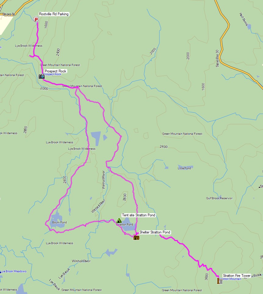
Route Overview – Stratton Pond Vermont Backpacking Loop – Sintax77
Full GPS track data, including campsites, etc, for this trip and many others can be downloaded on my Trip Data Page.
Trailhead Used: Prospect Rock Trailhead
663 Rootville Rd, Manchester, VT 05255
43°10’20.6″N 73°00’43.7″W
This is an easily accessible parking area at the end of Rootville Rd with room for 3 or so vehicles. No fee or permit is required to park or backcountry camp in this area.
Trails Used Day 1
- Follow the gravel road up the hill to the info board.
- Prospect Rock Trail
- Appalachian Trail / Vermont Long Trail South
- Spur Trail to Stratton Pond Shelter
- Camp at Stratton Pond Shelter
- Shelter on both nights of my 3 day Stratton Pond backpacking trip in Vermont’s Lye Brook Wilderness. This is a very nice shelter with room for a dozen people, a firepit, nearby composting toilet and water available at the pond or one of the nearby streams that feed it.
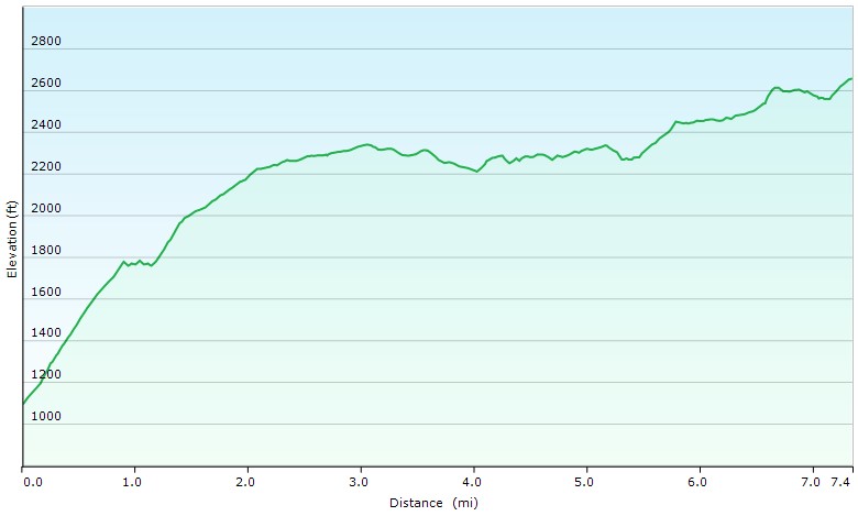
Day 1 Elevation Profile – Stratton Pond Vermont Loop – Sintax77
Day 1 Mileage: 7.4 miles
Day 1 Gross Elevation Gain: 2,065′
Day 1 Gross Descent: 501′
Trails Used Day 2
- Leave camping gear at the shelter.
- Appalachian Trail / Long Trail South
- Stratton Fire Tower
- Backtrack to the shelter
- Camp at Stratton Pond Shelter
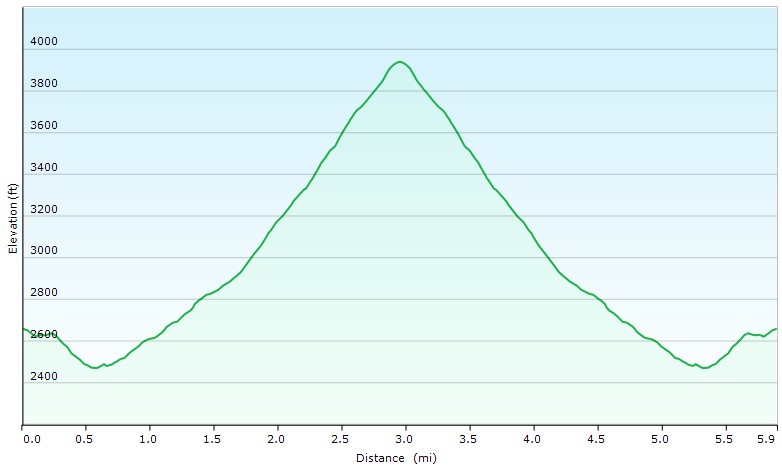
Day 2 Elevation Profile – Stratton Pond Vermont Loop – Sintax77
Day 2 Mileage: 6 miles
Day 2 Gross Elevation Gain: 1,713′
Day 2 Gross Descent: 1,713′
Intended Route Day 3
- Stratton Pond Trail
- Lye Brook Trail
- Branch Pond Trail
- Appalachian Trail North
- Prospect Rock Trail
- Return to parking
- The Winhall River Crossing on Lye Brook Trail was impassable (at least by winter temp standards) so I turned back and used my Day 1 route from Stratton Pond. The mileage and elevation for both routes are nearly identical.
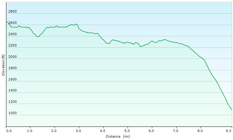
Day 3 Elevation Profile – Stratton Pond Vermont Loop – Sintax77
Day 3 Mileage: 9.3 miles
Day 3 Gross Elevation Gain: 720′
Day 3 Gross Descent: 2,286′
Grand Total Mileage: 22.7 miles
Notable Backpacking Gear
- ULA Ohm 2.0 Backpack
- Dutchware Pack Cover
- Dutchware Gear Half-wit Hammock with Beetle Buckle Suspension
- Hammock Gear Burrow 40 Top Quilt
- Simply Light Designs Trail Winder Underquilt
- Hammock Gear Dyneema Hex Tarp
- DIY Cat Can Alcohol Stove
- Vargon Aluminum Windscreen
- Light My Fire Mini Fire Steel Striker
- Toaks 750ml Titanium Pot
- Sea to Summit Long Handled Spork
- Potable Aqua Water Purification Tablets with PA Plus
- Outdoor Research Helium III Rain Jacket
- Outdoor Vitals Adventure Jacket, Loftek version
- RevolutionRace Campfire Shirt
- RevolutionRace Men’s GP Pants
- Nitecore NU25 Headlamp
- Benchmade Bugout EDC Folding Knife
- Casio ProTrek F-30 Smartwatch
- Mountain House Backpacking Meals
- Spot X Satellite Messenger

Camera Gear used for this episode