
Backpacking, Hiking & Winter Tent Camping with Snow in Pennsylvania’s Hammersley Wild Area.
FTC Disclosure: This post contains affiliate links, which means I may receive a commission for purchases made through some of my links.
For this early December backpacking trip, I set out to hike a 3 day, 20ish mile loop in the mountains of north central Pennsylvania. I created my loop by using a portion of the Susquehannock Trail System, some off-trail bushwhacking, and a ridge hike along the adjacent Twin Sisters Trail.
My weather conditions were forecasted to have some fresh snow, temps mostly in the 20’s and a potential for freezing rain as the temps rose further into the trip. While this was a pretty wide range of possible conditions, it also wasn’t terribly cold, so I was still able to pack somewhat ultralight and minimal. My camping target for day one was down in the hollow along the banks of Hammersley Fork. On day two I planned to head up to the ridge and camp in the area devoid of trees due to a forest fire back in 1962. Due to the potential lack of trees, I swapped out my typical hammock setup for a single person tent and sleeping pad to keep my campsite options flexible.
The Hammersley Wild Area is the most remote swath of public land in Pennsylvania, with some spots over 5 miles from the nearest road, which combined with the season, I hoped would make for some rather secluded camping. Conversely, this area is also a haven for public hunting, so I made sure to wear some blaze orange and remain somewhat quiet and on the trail until I got further away from any road access, as it was the middle of PA deer hunting season.
This trip video was sponsored by Dr Prepare. You can get 10% off their 178Wh Portable Power Station by using code STDP10 with this link.
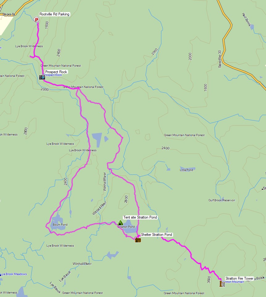
Route Overview – Stratton Pond Vermont Backpacking Loop – Sintax77
Full GPS track data, including campsites, etc, for this trip and many others can be downloaded on my Trip Data Page.
Trailhead Used: Susquehannock Trail Crossfork Parking
75 Fire House Ln, Cross Fork, PA 17729
41°28’54.8″N 77°49’06.6″W
This is an easily accessible parking area located right next to the Kettle Creek Fire Station. You’ll see signs designating where you can park for overnight or day hiking use. The actual trail begins back up on Rt 144.
Trails Used Day 1
- Road Hike back over the bridge on Main Street
- Left (south) on Rt 144 (you’ll see orange blazes along the road)
- Just after Windfall Rd, hop the guard rail and follow the blazes into the woods
- Continue on the Susquehannock Trail (STS)
- Camp along the STS and Hammersley Fork at a site known as “the pool”
- This is a large established campsite with a firepit, reliable water, and room for several tents or hammocks.
Day 1 Mileage: 6.6 miles
Day 1 Gross Elevation Gain: 1,380′
Day 1 Gross Descent: 1,114′
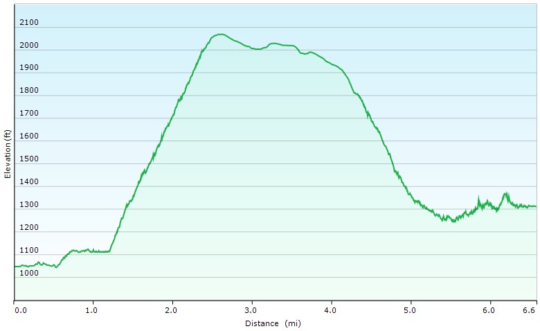
Day 1 Elevation Profile – Hammersley Wild Area Backpacking Loop – Sintax77
Trails Used Day 2
- Continue north on the STS
- Leave trail to the right (east) to begin a bushwhack up to Elk Lick Knob
- This is a random bushwhack. There is no established path, markings or indicators, but I began about one mile after passing the Bunnel Ridge Trail. I crossed Hammersley Fork and headed uphill when I was almost directly adjacent to Elk Lick Knob to the east.
- Intersect with the Twin Sisters Trail and turn right (south)
- Camp in the woods along TS trail
- The clearing I hoped to camp in ended up being covered in dense underbrush and saplings, so I cut my losses and headed further into the woods. With the approaching darkness I was unable to scout around for too long, but it’s entirely possible that there are some nicer camping spots out on the bald.
Day 2 Mileage: 6.6 miles
Day 2 Gross Elevation Gain: 1,381′
Day 2 Gross Descent: 454′
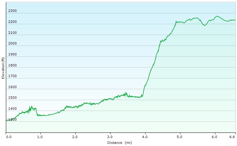
Day 2 Elevation Profile – Hammersley Wild Area Backpacking Loop – Sintax77
Route Day 3
- Continue south on the Twin Sisters Trail
- Straight (south) on STS
- Follow road back to parking
Day 3 Mileage: 6.3 miles
Day 3 Gross Elevation Gain: 314′
Day 3 Gross Descent: 1,505′
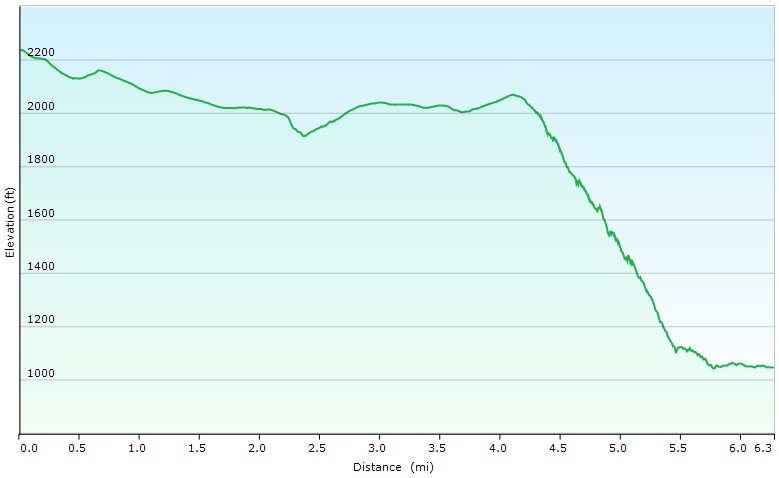
Day 3 Elevation Profile – Hammersley Wild Area Backpacking Loop – Sintax77
Grand Total Mileage: 19.5 miles
Grand Total Elevation Gain: 3,075′
Notable Backpacking Gear
- ULA Ohm 2.0 Backpack
- Dutchware Pack Cover
- Outdoor Vitals 1p Tent
- Outdoor Vitals Storm Loft 15° Mummy Pod
- Amok Fjol XL Winterlight Sleeping Pad
- DIY Cat Can Alcohol Stove
- Vargo Aluminum Windscreen
- Light My Fire Mini Fire Steel Striker
- Toaks 750ml Titanium Pot
- Sea to Summit Long Handled Spork
- Potable Aqua Water Purification Tablets with PA Plus
- Marmot Eclipse Hardshell Jacket
- Outdoor Research Helium III Rain Pants
- RevolutionRace Men’s Norwand Pants
- Outdoor Vitals Adventure Jacket, Loftek version
- Nitecore NU25 Headlamp
- Silky F-180 Folding Saw
- Benchmade Bugout EDC Folding Knife
- Casio ProTrek F-30 Smartwatch
- Packit Gourmet Backpacking Meals
- Spot X Satellite Messenger

Camera Gear used for this episode