
Join me for 3 days of Winter Camping, Backpacking & Hiking in the Smoky Mountains.
For this winter camping adventure, I decided to do a solo backpacking loop along the Little River Gorge in Tennessee’s western region of Great Smoky Mountains National Park. The Little River is flanked to the south by Meigs Mountain and to the north by Sugarland Mountain. By hiking trails along the ridges of both these mountains, I was able to create a 25 mile loop with 6,000 feet of gross elevation gain.
On the first night, I chose to camp on top of Meigs Mountain at campsite 19, Upper Henderson. On day two I planned to descend into the gorge to camp along the Little River at campsite 21. On the third day, I would hike up Sugarland Mountain towards Laurel Falls and ultimately, Little Brier Gap to complete the loop.
For sleep and shelter, I packed in my Outdoor Vitals Fortius trekking pole tent, a 3-season sleeping pad and my Hammock Gear 20° down quilt. Despite it being the middle winter, my temp range was relatively mild with lows in the 40’s and highs touching the mid 60’s. This allowed me to leave my extra cold weather clothing layers at home, so I was still able to use my ultralight backpack instead of the larger pack that I typically use for winter. Days 2 and 3 had a forecast of rain and high winds, so I played it safe and packed in full set rain gear as well.
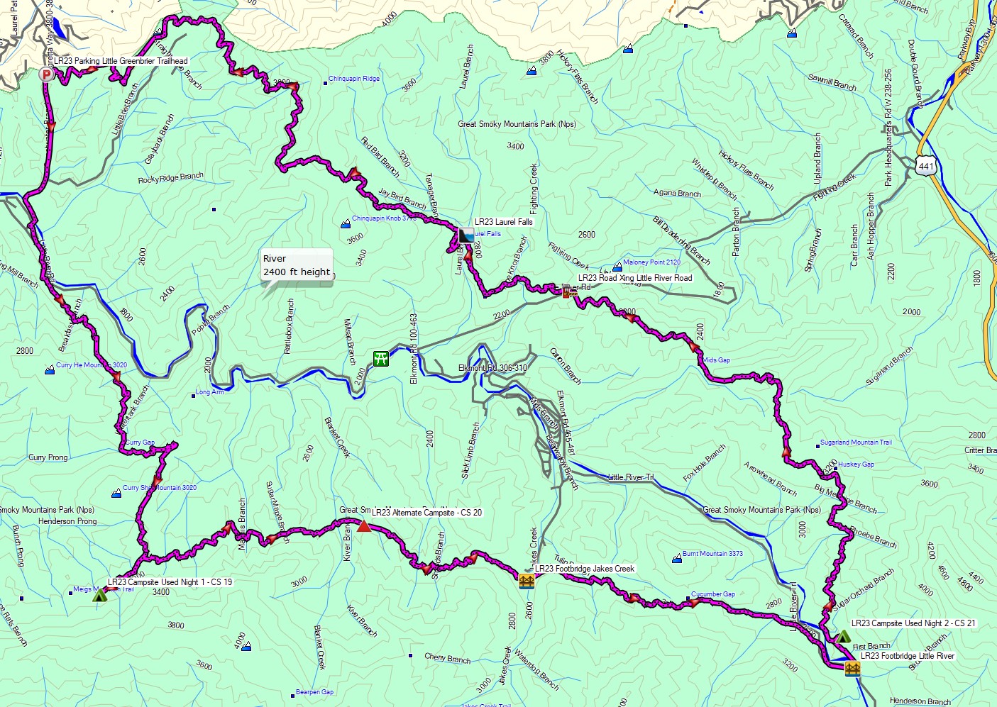
Route Overview – Smoky Mountains Little River Gorge Backpacking Loop – Sintax77
A backcountry permit is required for all campsites in this area. You can reserve them for $8 per night on the Smoky Mountains National Park website here.
Full GPS track data, including campsites, water sources, etc, for this trip and many others can be downloaded on my Trip Data Page.
Trailhead Used: Little Greenbrier Trailhead, 35°41’39.3″N 83°38’44.9″W
Wear Cove Gap Rd, Sevierville, TN 37862
This is a easily accessible, but small parking area with room for only a few cars, which may fill up quickly with day hikers. If it’s full, you could always start and end the loop 1 mile down the road at the larger Metcalf Bottoms parking area.
Trails Used, Day 1
- Begin at Little Greenbrier Trailhead
- Road hike 1 mile downhill to Metcalf Bottoms
- Cross Little River via the auto bridge.
- Curry Mountain Trail
- Right (west) on Meigs Mountain Trail for a half mile.
- Setup Camp at campsite 19, Upper Henderson.
- This seems to be a lesser used campsite, with a few smaller spots for individual tents staggered along the side of a hill. There are two established campfire pits, bear cables for hanging food, and a nearby brook providing a reliable water source.
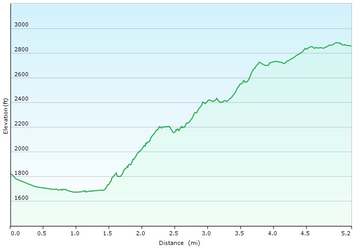
Day 1 Elevation Profile – Smoky Mountains Little River Gorge Backpacking Loop – Sintax77
Day 1 Mileage: 5.2 Miles
Day 1 Elevation Gross Gain: 1,562′
Day 1 Elevation Gross Descent: 528′
Trails Used, Day 2
- Backtrack a half mile on Meigs Mountain Trail
- At the intersection, continue on Meigs Mountain Trail
- Cross Jakes Creek via footbridge and take the Cucumber Gap Trail
- Cross the Little River via the footbridge.
- Huskey Gap Trail
- Setup camp along the Little River at campsite 21
- This is a large campsite with many options for tent camping or hammocks. There are several established campfire pits, bear cables, and reliable water available from the river about 200 meters from camp.
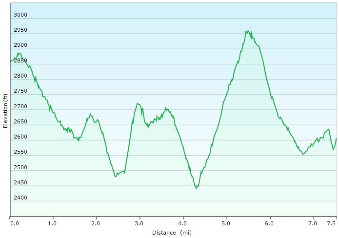
Day 2 Elevation Profile – Smoky Mountains Little River Gorge Backpacking Loop – Sintax77
Day 2 Mileage: 7.5 Miles
Day 2 Gross Elevation Gain: 1,333′
Day 2 Gross Descent: ‘1,586
Trails Used, Day 3
- Continue north on the Huskey Gap Trail
- Left (west) on the Sugarland Mountain Trail
- Laurel Falls Trail
- Left (west) on the Little Greenbrier Trail
- Return to the Little Greenbrier Trailhead
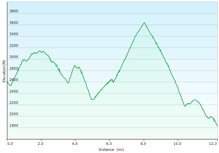
Day 3 Elevation Profile – Smoky Mountains Little River Gorge Backpacking Loop – Sintax77
Day 3 Mileage: 12.3 Miles
Day 3 Gross Elevation Gain: 3,039′
Day 3 Gross Descent: 3,833′
Grand Total 3 Day Mileage: 25 Miles
Grand Total 3 Day Elevation Gain: 5,934′