
Backpacking, Camping in the Rain, and Trail Cooking in Virginia’s Shenandoah National Park.
FTC Disclosure: This post contains affiliate links, which means I may receive a commission for purchases made through some of my links.
For this overnight backpacking trip, Sara, Denali and I decided to do some early spring camping on the Shenandoah’s Rocky Mount Trail and Gap Run trail. Combining the two would create a roughly 10 mile backpacking loop with sweeping mountain views on the first day, and peaceful babbling brooks on the second.
We had our dog with us on this trip, so we returned to using our budget tent to keep the group together. The weather on day one had a 100% chance of rain, so I also brought along a huge tarp to give us a common area with a view of the impending storm without being stuck inside the tent the whole afternoon. More details on our gear can be found at the bottom of this post.
Off course all of this would depend on whether or not we could find Sara’s elusive secret camping spot before the rain began to really come down…
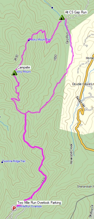
Shenandoah Rocky Mount Loop – Route Overview – Sintax77
There is an entrance fee for Shenandoah National Park to access Skyline drive. Backcountry camping is free, but you need to self register for a permit at the entrance station. You can find more information on the official SNP website here.
Full GPS track data, including campsites, water sources, etc, for this trip and many others can be downloaded on my Trip Data Page.
Trailhead Used: Rocky Mount Trailhead by Two Mile Run Overlook
38°17’56.8″N 78°38’49.9″W
Skyline Dr, Elkton, VA 22827
The Rocky Mount trailhead is located Skyline drive, just north of the Two Mile Run Overlook. There is no parking available directly in front of the trailhead, so you’ll need to park at the overlook and do a short walk.
Trails Used, Day 1
- Rocky Mount Trail to the summit of Rocky Mount
- Camp near the summit of Rocky Mount
- This is a dry site with no water encountered on the hike in, so make sure to pack in enough water. Despite the appearance of fire rings in the area, fires are not permitted in the backcountry of Shenandoah National Park.
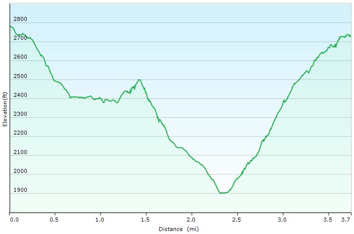
Day 1 Elevation Profile – Shenandoah Rocky Mount Loop – Sintax77
Day 1 Mileage: 3.7 miles
Day 1 Gross Elevation Gain: 1,028 feet
Day 1 Gross Descent: 1,078 feet
Trails Used, Day 2
- Continue on Rocky Mount Trail
- Right (southeast) on Gap Run Trail
- Left (south) on Rocky Mount Trail
- Return to parking at the Two Mile Run Overlook
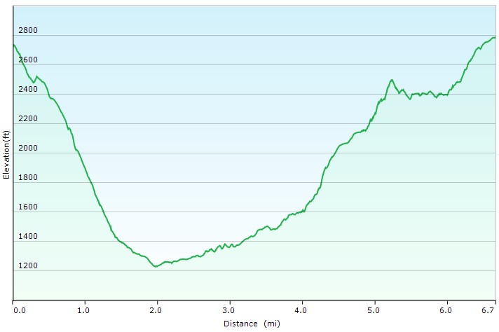
Day 2 Elevation Profile – Shenandoah Rocky Mount Loop – Sintax77
Day 2 Mileage: 6.7 miles
Day 2 Gross Elevation Gain: 1934 feet
Day 2 Gross Descent: 1,883 feet
Grand Total Mileage: 10.4 Miles
Grand Total Gross Elevation Gain: 2,962 feet
Grand Total Descent: 2,961 feet
Notable Backpacking Gear
- Sara’s ULA Ohm 2.0 Backpack
- My Fjallraven Kajka 75 Backpack
- Ozark Trails 4 Person Dome Tent
- Dutchware Xenon 2 Person Tarp
- Outdoor Vitals Storm Loft 15° Mummy Pod
- Sara’s Amok Fjol XL Winterlight Sleeping Pad
- Sintax77’s Unigear Sleeping Pad
- Dutchware UP Booties
- MalloMe Camp 1L Pot
- BSR Ultralight Canister Stove
- MSR Flex Skillet
- Light My Fire Mini Fire Steel Striker
- Light My Fire Tritan Spork
- Vargo 450ml Mug
- Potable Aqua Water Purification Tablets
- Shawn’s Marmot Eclipse Hardshell Jacket
- Outdoor Vitals Adventure Jacket, Loftek version
- Outdoor Vitals Satu Adventure Pants
- La Sportiva Wildcat Trail Running Shoes
- Nitecore NU25 Headlamp
- Nite Ize Lantern
- Casio ProTrek F30 Smartwatch
- Sangean Radio DT-400W weather band radio
- Benchmade Bugout EDC Folding Knife
- Packit Gourmet Backpacking Meals


Camera and Nav Gear used for this episode