Camping in Heavy Rain – Pinchot Trail South Loop Backpacking Trip

Join Sara and I for some Spring Backpacking, Camping in the Rain, and Trail Cooking on the Pinchot Trail southern loop.


FTC Disclosure: This post contains affiliate links, which means I may receive a commission for purchases made through some of my links.

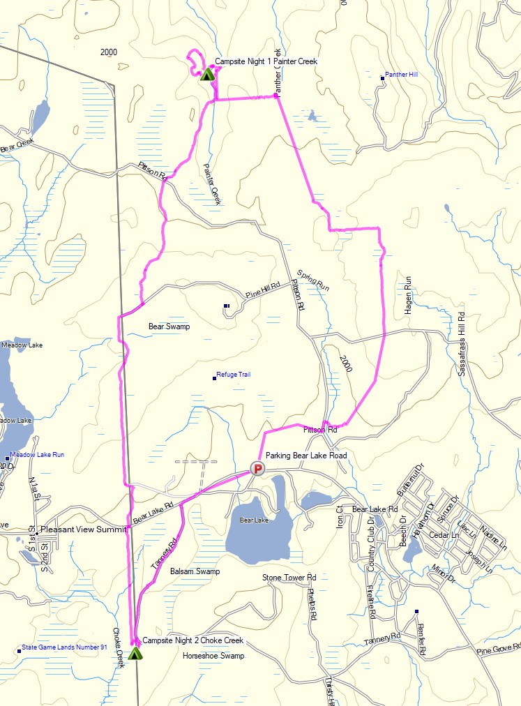
For this early spring camping trip, my wife Sara and I set out to do some backpacking  with our dog and explore Pennsylvania’s Pinchot Trail southern loop.  I had done the northern loop a couple of weeks before and it was quite nice, so I was looking forward to seeing what this new section had to offer.

For shelter, we packed in our 4 person tent as well as a huge tarp to give us some extra living space during the rain storm that was forecasted to hit in the afternoon and turn into snow by the next morning.

The bottom of the Pinchot Trail South loop runs along Choke Creek, which offers a string of 6 or so beautiful waterside campsites over the course of a mile or so. Legend has it that the last of those campsites is the most picturesque, so our goal was to hike in a few miles to the creek and get to that coveted campsite before the afternoon rain started. If the weather broke early, we would aim to take one of the earlier campsites.

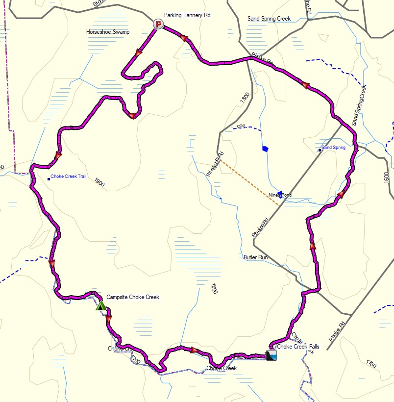
Route Overview – Pinchot Trail South Backpacking Loop – Sintax77

Continue reading

3 Days Winter Camping with NO STOVE – Cooking with Fire!

3 Days of Winter Camping, Backpacking & Campfire Cooking in Pennsylvania’s Pinchot State Forest.


FTC Disclosure: This post contains affiliate links, which means I may receive a commission for purchases made through some of my links.

For this late winter backpacking trip, I decided to challenge myself to cook “real food” using only fire for the duration of my trip. If you know anything about my patience for making fires, you’ll know this will truly be a bit of a challenge. 🙂

For shelter, I went with my minimalist camping hammock and ultralight backpacking tarp set-up. I also utilized a grill grate, a folding saw for harvesting campfire wood, and some extra cold weather clothing layers, as the temps were forecasted to head down to  around 15° F or so. There was also a chance of snow, sleet, and even rain, so I brought a full set of rain gear for warmth at camp and keeping dry while hiking.

Full Route Overview – Pinchot Trail North Backpacking Loop – Sintax77

Continue reading

3 Days of Campfire Cooking and Hammock Camping – Harpers Ferry West Virginia

Hammock Camping, Trail Cooking and the search for an Elusive Hearth in the Woods of West Virginia.

FTC Disclosure: This post contains affiliate links, which means I may receive a commission for purchases made through some of my links.

For this early February hammock camping trip, I set out to hike a 3 day hike with a nostalgic goal – to find a giant campfire hearth that my friend and I had built five years ago, somewhere off of the Appalachian Trail near the town of Harpers Ferry, West Virginia.  I had always wondered if it was still standing after all these years, and thought it would be a great excuse to spend some time in the woods a cook some hearty camping meals.

My weather conditions were forecasted to have a pretty wide range during this trip, from the upper 50’s down to 30 degrees each evening.  I had a rough idea of the hearth’s location.  We built it at camp not too long after leaving the Harpers Ferry National Historic Area’s boundary while heading south on the Appalachian Trail.  My goal for the first day was to get myself to a legal camping area in this general area so I could search for it first thing the next morning.  If I found it early, I would then have the option to do a day hike to Loudoun Heights and Split Rock for views of the Shenandoah River and Potomac River below the ridge.

For sleep and shelter on this trip, I went with a simple hammock camping and ultralight tarp setup (gear list below).  I used the extra space in my winter backpack to load up on extra clothing layers, a saw for harvesting firewood, a stool for working in my makeshift camp kitchen, and my white gas stove system paired up with a fry pan and diffuser to try my hand at baking some trail bread at camp.  The cooler temps also allowed me to bring some “real” food, so I brought along some ingredients to make some smoked sausage one day and pasta with a slow cooked meat sauce the next.

This trip video was sponsored by Anker and their model 521 and 535 Portable Power Station.

Route Overview – Harpers Ferry Loudoun Heights Winter Backpacking Trip – Sintax77

Full GPS track data, including campsites, etc, for this trip and many others can be downloaded on my Trip Data Page.

Continue reading

Honey I Forgot the Tent – When Backpacking Goes Wrong

Hiking, Backpacking and an attempt at Tent Camping in the Rain in Virginia’s George Washington National Forest.

FTC Disclosure: This post contains affiliate links, which means I may receive a commission for purchases made through some of my links.

For this overnight backpacking trip, Sara and I decided to do some summer backpacking with our dog on a section of Great North Mountain, a 50 mile long mountain ridge that runs along the border of West Virginia and Virginia.

Despite the threat of a quickly approaching storm, we decided to forge ahead with a modest 3 day, 7 mile backpacking trip. Our plan was to keep the itinerary relatively simple in hopes that we could get to camp in time to beat the rain. And then we ran into a slight complication. Actually, it wasn’t slight at all. It was quite possibly the biggest backpacking mistake I’ve ever made…

White Rock Cliff Loop Virginia – Route Overview – Sintax77

There is no parking fee or backcountry camping permit required for this section of the George Washington and Jefferson National Forest.  More details regarding dispersed camping can be found on the official GWJNF website here.

Full GPS track data, including campsites, water sources, etc, for this trip and many others can be downloaded on my Trip Data Page.

This trip video was sponsored by RevolutionRace. Use code 15sintax to get 15% off their entire Amazon store site until 9/11/21 here.

Trailhead Used: Sulphur Springs Parking Area Forest Road 1725
38°58’31.4″N 78°34’03.5″W
FR1725, Maurertown, VA 22644

Continue reading

Camping in the Rain – Sara’s Secret Campsite

Backpacking, Camping in the Rain, and Trail Cooking in Virginia’s Shenandoah National Park.

FTC Disclosure: This post contains affiliate links, which means I may receive a commission for purchases made through some of my links.

For this overnight backpacking trip, Sara, Denali and I decided to do some early spring camping on the Shenandoah’s Rocky Mount Trail and Gap Run trail.  Combining the two would create a roughly 10 mile backpacking loop with sweeping mountain views on the first day, and peaceful babbling brooks on the second.

We had our dog with us on this trip, so we returned to using our budget tent to keep the group together.  The weather on day one had a 100% chance of rain, so I also brought along a huge tarp to give us a common area with a view of the impending storm without being stuck inside the tent the whole afternoon. More details on our gear can be found at the bottom of this post.

Off course all of this would depend on whether or not we could find Sara’s elusive secret camping spot before the rain began to really come down…

Thank you to Private Internet Access for sponsoring this video.  My viewers can get complete digital privacy for less than $3 a month and 3 months free by using this link.

Shenandoah Rocky Mount Loop – Route Overview – Sintax77

There is an entrance fee for Shenandoah National Park to access Skyline drive.  Backcountry camping is free, but you need to self register for a permit at the entrance station.  You can find more information on the official SNP website here.

Full GPS track data, including campsites, water sources, etc, for this trip and many others can be downloaded on my Trip Data Page.

Continue reading

Winter Camping and Finding a Plane Crash – Mt Success DC-3

Backpacking & Solo Winter Camping in search of a 1954 commercial airline crash near the summit of Mt Success in the White Mountains.

FTC Disclosure: This post contains affiliate links, which means I may receive a commission for purchases made through some of my links.

For this 3 day, 2 night camping trip, I headed up to a lesser traveled corner of New Hampshire’s White Mountain National Forest for some snowshoeing, camp cooking, and bit of New England aviation history.

My goal for this adventure was to find the resting place of Northeast Airlines Flight 792, which crashed on approach to Berlin Municipal Airport during inclement weather on November 30th, 1954. It made contact in the dense trees near the summit of Mt Success at an elevation of 3,390 feet.  More information on the details of Flight 792 and the circumstances of it’s survivors can be found in this copy of the official Accident Investigation Report

The 6.5 mile hike to get there would require a gross elevation gain of roughly 3,700 feet on potentially unbroken trail in deep snow.  The final portion of the hike would be an unofficial bushwhack through dense trees and snow.  For this reason, I chose to break up the approach up by setting up camp at roughly the halfway point along Gentian Pond and the nearby lean-to shelter with sweeping views of the Carter-Moriah mountain range.  After camping for the night, I would head up to the top of Mt Success, the first peak of the Mahoosuc Range and the Appalachian Trail’s gateway to Maine. After a few miles and a couple thousand feet of ascent with my trusty snowshoes, I would leave the trail behind in search of the DC-3.

Mt Success DC-3 Winter Backpacking Trip – Route Overview

No permit is required to backcountry camp in the White Mountains, but some locations do require a daily, weekly, or annual pass.  The parking area for this trip did not require a parking fee as of January 2021.

Full GPS track data, including campsites, water sources, etc, for this trip and many others can be downloaded on my Trip Data Page.

Trailhead Used: Austin Brook Trailhead on North Road,  44°24’45.1″N 71°04’05.4″W
North Rd, Shelburne, NH 03581

Continue reading