3 Days of Campfire Cooking and Hammock Camping – Harpers Ferry West Virginia

Hammock Camping, Trail Cooking and the search for an Elusive Hearth in the Woods of West Virginia.

FTC Disclosure: This post contains affiliate links, which means I may receive a commission for purchases made through some of my links.

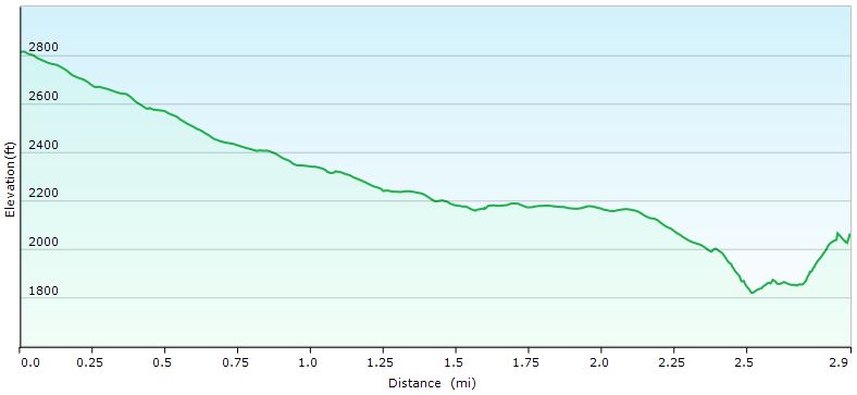
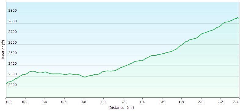
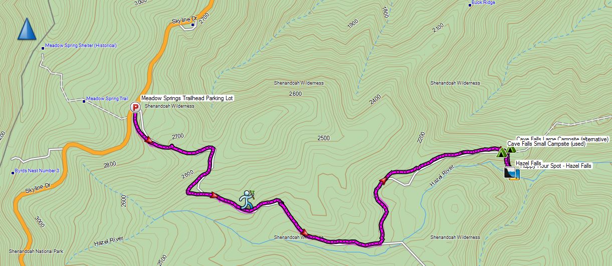
For this early February hammock camping trip, I set out to hike a 3 day hike with a nostalgic goal – to find a giant campfire hearth that my friend and I had built five years ago, somewhere off of the Appalachian Trail near the town of Harpers Ferry, West Virginia.  I had always wondered if it was still standing after all these years, and thought it would be a great excuse to spend some time in the woods a cook some hearty camping meals.

My weather conditions were forecasted to have a pretty wide range during this trip, from the upper 50’s down to 30 degrees each evening.  I had a rough idea of the hearth’s location.  We built it at camp not too long after leaving the Harpers Ferry National Historic Area’s boundary while heading south on the Appalachian Trail.  My goal for the first day was to get myself to a legal camping area in this general area so I could search for it first thing the next morning.  If I found it early, I would then have the option to do a day hike to Loudoun Heights and Split Rock for views of the Shenandoah River and Potomac River below the ridge.

For sleep and shelter on this trip, I went with a simple hammock camping and ultralight tarp setup (gear list below).  I used the extra space in my winter backpack to load up on extra clothing layers, a saw for harvesting firewood, a stool for working in my makeshift camp kitchen, and my white gas stove system paired up with a fry pan and diffuser to try my hand at baking some trail bread at camp.  The cooler temps also allowed me to bring some “real” food, so I brought along some ingredients to make some smoked sausage one day and pasta with a slow cooked meat sauce the next.

This trip video was sponsored by Anker and their model 521 and 535 Portable Power Station.

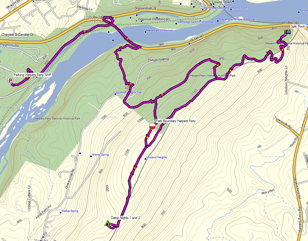
Route Overview – Harpers Ferry Loudoun Heights Winter Backpacking Trip – Sintax77

Full GPS track data, including campsites, etc, for this trip and many others can be downloaded on my Trip Data Page.

Continue reading

Sara Goes Hammock Camping …Again! – Hiking & Pancakes in Virginia

Join Sara and I for some hiking, trail cooking, and backpacking on  a hammock camping trip in Shenandoah National Park.

For this hiking adventure, Sara and I will be revisiting Shenandoah National park for Sara’s second dose of hammock camping out in the wild along with a healthy dose of backcountry cooking and camp food. We did a previous backpacking trip not too far from here in Shenandoah a mere two weeks before, and it went quite well.  It wasn’t, however, exactly the experience that we had set out to do.

You see, for that particular trip, I may have sold it as a rather relaxed excursion.  And depending on your perspective, it very well may have been just that.  But for Sara, who’s most recent backpacking memories prior to that trip were that of a grueling elevation-fest through the White Mountains, it wasn’t quite the reprieve we were looking for.

The required prescription was a high dose of low mileage, potent lounging, and dense pancakes.  Thankfully, the trip seen in this video hit the spot.  Below are some details and trip data for the trip, although there isn’t much of it.  But that’s exactly what we were going for.  Check out my Trip Data Page to get full GPS data for this trip.

Parking:  Meadow Spring Trailhead (Mile 34 on Skyline Drive)
N38° 38.304′ W78° 18.823′

Day 1 Trails Used (in order):
Hazel Mountain Trail
Turn Left on White Rocks Trail
Camp along White Rocks Trail (see my GPS Data for potential campsites on either side of trail)
After setting up camp, take a half mile round trip down to Hazel Falls, for happy hour.

Hazel Falls Day 1 Elevation Profile - Sintax77

Day 1 Stats:
Mileage: 3.2 miles (includes half mile excursion from camp down to Hazel Falls and back)
Gross Elevation Gain: 390′
Gross Elevation Loss: 1,175′

Day 2 Trails Used (in order):
Wake Up, Eat Pancakes (this is important – trip will not work properly without this step!)
White Rocks Trail
Right on Hazel Creek Trail

Hazel Falls Day 2 Elevation Profile - Sintax77

Day 2 Stats:
Mileage: 2.5 miles (not nearly enough to burn off those pancakes, you’re gonna have to go to the gym tomorrow…)
Gross Elevation Gain: 699′
Gross Elevation Loss: 75′

Total Mileage for Trip: 5.7 Miles

Hazel Falls 2 Day Trip Route Overview- Sintax77

Notable Gear Used for Sara:
Dutchware NylonD Hammock with Aluminum Cinch Buckles & Nylon Tree Straps
Hennessy Deluxe Tarp (10′ x 12′ 70D Polyester)
Hammock Gear Burrow 20° Top Quilt
Hammock Gear Incubator 0° Underquilt
Osprey Hornet 46 Backpack (See my Gear List using this pack here)
Thorfire BD04 USB rechargable LED Flashlight
Princeton Tech Byte Headlamp
ThruNight Titanium Keychain LED Flashlight
EMS Knitted Hat

Notable Gear Used for Shawn:
Dream Hammock Darien Ultralight Hammock (see my video on it here)
Hammock Gear Cuben Hex Tarp
Hammock Gear Burrow 40° Top Quilt
Hammock Gear Incubator 40° Underquilt w/ Epsilon 1.5 Multicam Fabric (see my video on it here)
EMS Longtrail 70 Backpack
4Sevens Preon 2 LED Flashlight
Fenix HL21 Headlamp (watch my review video here)
Generic Canister Stove (watch my review video here)
MSR Flex Skillet w/ cheap dollar store utensils for cooking

Notable Backpacking Food for this Trip:
Bisquick Shake ‘n Pour Pancake Mix
Packit Gourmet Dehydrated Maple Syrup and Blueberries
Packit Gourmet Queso Dip with a regular ol’ bag of Tostito’s Scoops (wheat, because we’re obviously healthy and stuff)
Packit Gourmet Texas State Fair Chili (I lost my mind eating this stuff on this winter video, after climbing Mt Washington)