
Join Sara and I for some Spring Backpacking, Camping in the Rain, and Trail Cooking on the Pinchot Trail southern loop.
FTC Disclosure: This post contains affiliate links, which means I may receive a commission for purchases made through some of my links.
For this early spring camping trip, my wife Sara and I set out to do some backpacking with our dog and explore Pennsylvania’s Pinchot Trail southern loop. I had done the northern loop a couple of weeks before and it was quite nice, so I was looking forward to seeing what this new section had to offer.
For shelter, we packed in our 4 person tent as well as a huge tarp to give us some extra living space during the rain storm that was forecasted to hit in the afternoon and turn into snow by the next morning.
The bottom of the Pinchot Trail South loop runs along Choke Creek, which offers a string of 6 or so beautiful waterside campsites over the course of a mile or so. Legend has it that the last of those campsites is the most picturesque, so our goal was to hike in a few miles to the creek and get to that coveted campsite before the afternoon rain started. If the weather broke early, we would aim to take one of the earlier campsites.
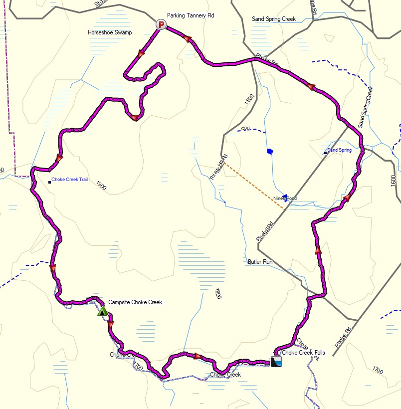
Route Overview – Pinchot Trail South Backpacking Loop – Sintax77
Trailhead Used: Choke Creek Nature Trail, Tannery Rd Tannery Rd, Thornhurst Township, PA 18424 41°12’01.4″N 75°37’54.8″W This is an easily accessible lot with room for two vehicles. There is no permit required to park or overnight camp.
GPS Data including campsites used, water sources and other POI’s for this trip and many others can be found on my Trip Data Page.
Trails Used Day 1
- Choke Creek Nature Trail (Yellow Blazed)
- Left at fork on Pinchot Trail / Choke Creek Nature Trail (Orange Blazed)
- Camp along Choke Creek / Pinchot Trail at 41.17547, -75.63853
- This is a large established campsite with a small rock cliff overlooking the creek. There is a rock firepit and room for several hammocks or a couple of tents. If this site is taken, there are 5 other obvious campsites in the mile leading up to it.
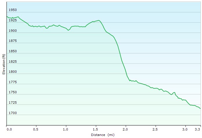
Day 1 Elevation Profile – Pinchot Trail South Loop Backpacking Trip – Sintax77
Day 1 Mileage: 3.3 miles
Day 1 Gross Elevation Gain: 66′
Day 1 Gross Descent: 291‘
Trails Used Day 2
- Continue on Choke Creek Trail / Pinchot Trail
- At the intersection, leave the Choke Creek trail and continue straight on the orange blazed Pinchot trail.
- Take in the sights at Choke Creek Falls
- Right (east) on Butler Creek Trail / Pinchot Trail
- Left (north) on Keller’s Swamp Trail (Pinchot Trail)
- Left (west) on Phelps Road
- Return to parking
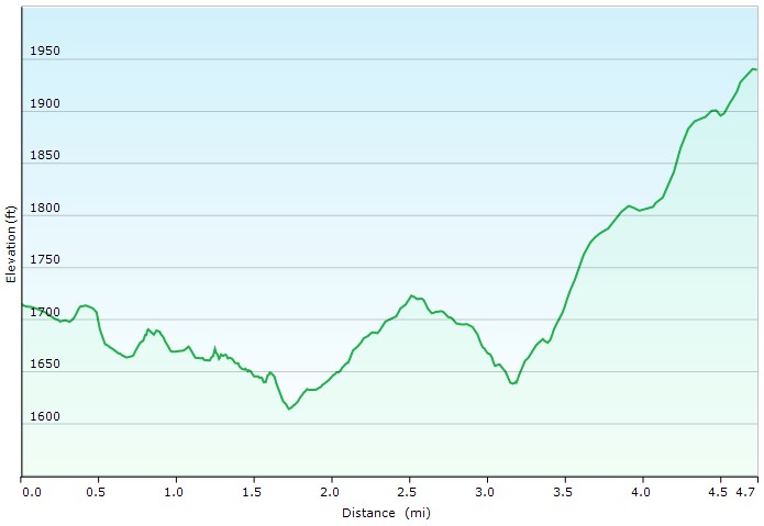
Day 2 Elevation Profile – Pinchot Trail South Loop Backpacking Trip – Sintax77
Day 2 Mileage: 4.7 miles
Day 2 Gross Elevation Gain: 513′
Day 2 Gross Descent: 288′
Grand Total Mileage: 8 miles
Grand Total Elevation Gain: 579′
- Notable Backpacking Gear
- Sara’s ULA Ohm 2.0 Backpack
- My Fjallraven Kajka 75 Backpack
- Marmot Limelight 4p Tent
- Dutchware Xenon 2 Person Tarp
- Outdoor Vitals Storm Loft 15° Mummy Pod
- Amok Fjol XL Winterlight Sleeping Pad
- Alite Mayfly Chair (discontinued)
- Optimus Polaris Optifuel Stove (running on white gas)
- MSR Flex Skillet
- Light My Fire Mini Fire Steel Striker
- Sea to Summit Alpha Light Long Spork
- Vargo 450ml Mug
- Pocket Bellows Fire Stoker
- Potable Aqua Water Purification Tablets
- Marmot Eclipse Hardshell Jacket
- Outdoor Vitals Adventure Jacket, Loftek version
- RevolutionRace Men’s Norwand Pants
- Nitecore NU25 Headlamp
- Casio ProTrek F30 Smartwatch
- Baofeng UV-5R radio
- Benchmade Bugout EDC Folding Knife
- Packit Gourmet Backpacking Meals
- Sara’s ULA Ohm 2.0 Backpack


Camera Gear used for this episode