
3 days of Hammock Camping & Solo Ultralight Backpacking on a 40 mile Grand Loop of the Linville Gorge Wilderness.
For this backpacking trip, I headed back down to North Carolina’s Pisgah National Forest for some hammock camping and another attempt at the “Grand Loop”, a roughly 40 mile trek with 11,000 feet of gross elevation gain.
The Linville Gorge Grand Loop is not a single official trail. It’s actually a patchwork of several official and unofficial trails. In fact, due to the extensive network of unofficial trails in the Gorge, there isn’t really any one “real” way to do the loop. The basic goal is simply to circumnavigate the gorge, hiking along the Linville River on the west side, and along the ridge top of the gorge on the east side. Whatever trails you decide to use is really up to you.
The upper ridges stand an average of 1,400 feet above the river banks below, with trails frequently descending down to the river and back up again on rugged terrain, without signage or trail blazes, and minimal use of switchbacks. This can make for some challenging hiking, that I personally believe to be some of the toughest on the east coast. The pay off is a heavy sense of adventure compared to traditional trails and some amazing mountain top views of the surrounding Blue Ridge Mountains.
- Thank you to Upstart for sponsoring this trip. See how they can help you build your credit and get free of high interest debt at Upstart.com/Sintax
My mid-May temperature range for this trip was between 45° and 85° with no rain in the forecast until the end of the third day. This allowed me to get my backpack’s base weight down to around 9 lbs by leaving my puffy jacket and extra base layers at home. I simply packed a long sleeve shirt and my ultralight rain jacket for supplemental warmth at camp if needed.
I went with a fairly minimalist hammock camping setup for this trip. There are plenty of trees and fun unofficial campsite gems to be found in the Gorge that make it ideal for hammocks. Water is obviously of minimal concern for the lower regions of the gorge. This allows you to save some weight on trails in those sections, but make sure to stock up when your route heads up towards the ridge. Especially if you’re looking to camp in one the beautiful ridge side campsites up there. Fortunately, I was able to take advantage of several springs up on the ridge that were still flowing at the time of my trip.
A free permit is required on weekends and holidays from May 1st through October 31st each year. You can find more information on the NFS Grandfather Ranger District website here.
If planning your own trip, I would highly recommend visiting LinvilleGorge.net for maps, info and extensive GPS data including official and unofficial trails, campsites, water sources, etc. They also have a free version of their map available on the Avenza phone app. Due to the fact that their data is so darn good, I didn’t package my own GPS file for this trip, but you can use this Caltopo link that someone from LinvilleGorge.net posted containing all of the trails and POI coordinates
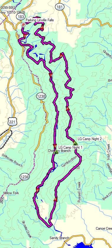
Route Overview – Linville Gorge Grand Loop Backpacking Trip 2022 – Sintax77
Trailhead Used: Linville Falls Visitor Center , 35°57’16.9″N 81°55’40.2″W
Warrior Ln, Marion, NC 28752
This is an easily accessible paved parking lot with room for a ton of cars and bathrooms on site.
Trails Used, Day 1
- Erwin’s View Trail
- Marion Wright Trail
- Linville Gorge Trail
- Camp along the Linville Gorge Trail on the Linville River near Chimney Run
- There are a ton of campsites along the river in this area, some more obvious than others.
Day 1 Mileage: 11.5 miles
Day 1 Gross Elevation Gain: 1,936′
Day 1 Gross Descent: 3,602′
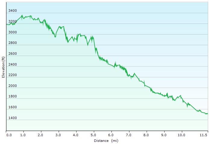
Day 1 Elevation Profile – Linville Gorge Grand Loop 2022 – Sintax77
Trails Used, Day 2
- Linville Gorge Trail
- Mountains to Sea Trail (MST)
- Cross the Linville River
- Continue on the MST towards Shortoff Mountain
- Jeep Trail (has a spring for water along it)
- Rejoin MST
- Refill Water at the spring by Saddle Camp
- Camp in Chimney Gap
Day 2 Mileage: 11.8 miles
Day 2 Gross Elevation Gain: 3,297′
Day 2 Gross Descent: 2,185′
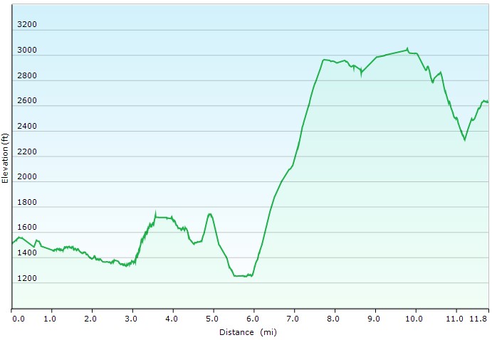
Day 2 Elevation Profile – Linville Gorge Grand Loop 2022 – Sintax77
Trails Used, Day 3
- MST
- Little Table Rock Trail
- Spence Ridge Trail
- Ledge Connector Trail
- Ledge Trail
- Hawksbill Mountain Trail
- Jonas Ridge Trail
- Devil’s Cliff Trail
- Red South Trail
- Brushy Ridge Trail
- Red North Trail
- Hill 3065 Trail
- Gulf Ridge Trail
- Gulf Contour Trail
- I skipped it, but if you want some extra challenge, you can add Yorricks Trail at the end.
- Return to parking lot
Day 3 Mileage: 15.7 miles
Day 3 Gross Elevation Gain: 5,621 feet
Day 3 Gross Descent: 5,063′
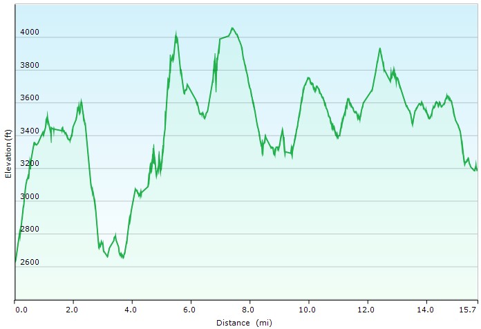
Day 3 Elevation Profile – Linville Gorge Grand Loop 2022 – Sintax77
Grand Total Mileage: 39 Miles
Grand Total Gross Elevation Gain: 10,850′
Notable Backpacking Gear
- ULA Ohm 2.0 Backpack
- Dutchware Pack Cover
- Dutchware Gear Half-Wit Hammock
- Hammock Gear Phoenix 30 Underquilt
- Hammock Gear Burrow 40 Top Quilt
- Hammock Gear Dyneema Hex Tarp
- DIY Cat Can Alcohol Stove
- Vargo Windscreen Pot Stand
- Toaks 750ml Titanium Pot
- Sea to Summit Long Handled Spork
- Potable Aqua Water Purification Tablets with PA Plus
- Outdoor Research Helium III Rain Jacket
- Outdoor Vitals Satu Adventure Pants
- La Sportiva Wildcat Trail Running Shoes
- Wright Socks (I love these for blister prevention, particularly in wet conditions).
- Nitecore NU25 Headlamp
- Spot X Satellite Messenger
- Casio ProTrek FR-30 Smartwatch
- Benchmade Bugout EDC Folding Knife
- Mountain House Backpacking Meals
- Packit Gourmet Backpacking Meals
- Korean Coffee Sticks

Camera Gear used for this episode
FTC Disclosure: This post contains affiliate links, which means I may receive a commission for purchases made through some of my links.