
3 days of Backpacking and Hammock Camping on Virginia’s Tuscarora Trail.
For this backpacking trip, I decided to head down to the border of West Virginia and Virginia to check out a pretty cool mountaintop lean-to shelter and do a little airplane scavenger hunt in-between the occasional rain showers that always tend to follow me around. On day one I would hike up to the ridge using the Tuscarora Trail, day two I would base camp and explore, and on day three I would hike back out via a different set of trails to complete the loop.
My options for shelter would be to either use the Gerhard Shelter lean-to if I had the place to myself, or a lightweight tarp and minimalist hammock if I decided to wander out further into the woods and camp near the search area and nearby spring.
My April temperature range for this trip was between 40° and 75°. This allowed me to get my backpack’s base weight down to around 10 lbs, while still including my puffy jacket and ultralight rain jacket for supplemental warmth at camp if needed.
The details of the aviation accident site that I was looking for can be found here. It was a small Cessna 150J that went down due to engine power loss and fortunately their were only minimal injuries to one of the two passengers. I’ve never read any reports of anyone actually finding or visiting this site, so I really had no idea if there would be anything to be found. But hey, it was a good excuse to get out into the woods, so I grabbed my pack and headed out for some adventure…
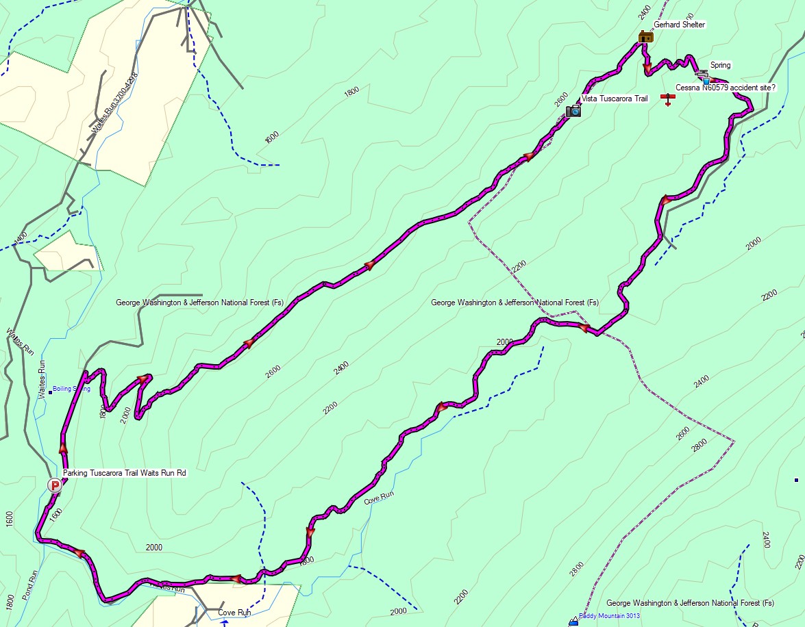
Route Overview – Gerhard Shelter Tuscarora Trail Backpacking Trip 2022 – Sintax77
Trailhead Used: Tuscarora Trail Waites Run Rd, 39°00’55.0″N 78°36’17.8″W
Waites Run, West Virginia 26851
This is an easily accessible parking area with room for a half dozen cars.
Full GPS track data, including campsites, etc, for this trip and many others can be downloaded on my Trip Data Page.
Trails Used, Day 1 Hike In
- Tuscarora Trail North
- Camp at Gerhard Shelter
- This is a very nice small shelter with a fire ring and space nearby for several tents or hammocks. Water can be obtained at the spring down the hill, but keep in mind that it’s a 1.2 mile round trip
Day 1 Mileage: 4.7 miles
Day 1 Gross Elevation Gain: 1,474′
Day 1 Gross Descent: 1,003′
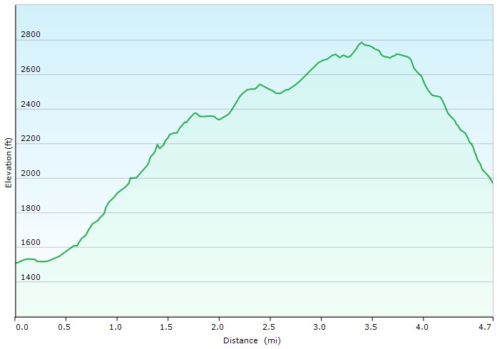
Day 1 Elevation Profile – Gerhard Shelter Tuscarora Trail Backpacking Trip 2022 – Sintax77
Day 2, Search for Cessna 150J crash site
- Head down Gerhard Shelter Trail
- Search for evidence of the 2017 Cessna 150J Incident
- Approximate location via the NTSB report is 39.039722,-78.555831
- Return to Camp at Gerhard Shelter
Trails Used, Day 3 Hike Out
- Gerhard Shelter Trail
- Bushwhack through accident site coordinates directly towards VCC Trail (optional of course)
- Vance’s Cove Connector Trail
- Wilson Cove Trail
- Return to parking lot via forest road
Day 3 Mileage: 5.1 miles
Day 3 Gross Elevation Gain: 427′
Day 3 Gross Descent: 893′
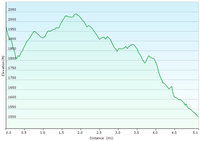
Day 3 Elevation Profile – Gerhard Shelter Tuscarora Trail Backpacking Trip 2022 – Sintax77
Total Trail Mileage: 9.8 Miles
Grand Total Gross Elevation Gain: 1,901′
Notable Backpacking Gear
- ULA Ohm 2.0 Backpack
- Dutchware Pack Cover
- Dutchware Gear Half-Wit Hammock
- Hammock Gear Phoenix 30 Underquilt
- Hammock Gear Burrow 40 Top Quilt
- Hammock Gear Dyneema Hex Tarp
- DIY Cat Can Alcohol Stove
- Vargo Windscreen Pot Stand
- Toaks 750ml Titanium Pot
- Sea to Summit Long Handled Spork
- Potable Aqua Water Purification Tablets with PA Plus
- Outdoor Research Helium III Rain Jacket
- RevolutionRace Men’s Norwand Pants
- La Sportiva Wildcat Trail Running Shoes
- Wright Socks
- Nitecore NU25 Headlamp
- Spot X Satellite Messenger
- Baofeng UV5-R Radio
- Casio ProTrek FR-30 Smartwatch
- Benchmade Bugout EDC Folding Knife
- Packit Gourmet Backpacking Meals

Camera Gear used for this episode
FTC Disclosure: This post contains affiliate links, which means I may receive a commission for purchases made through some of my links.