
3 Days of Ultralight Backpacking & Hammock Camping on the Carter-Moriah Range in the White Mountains of New Hampshire.
FTC Disclosure: This post contains affiliate links, which means I may receive a commission for purchases made through some of my links.
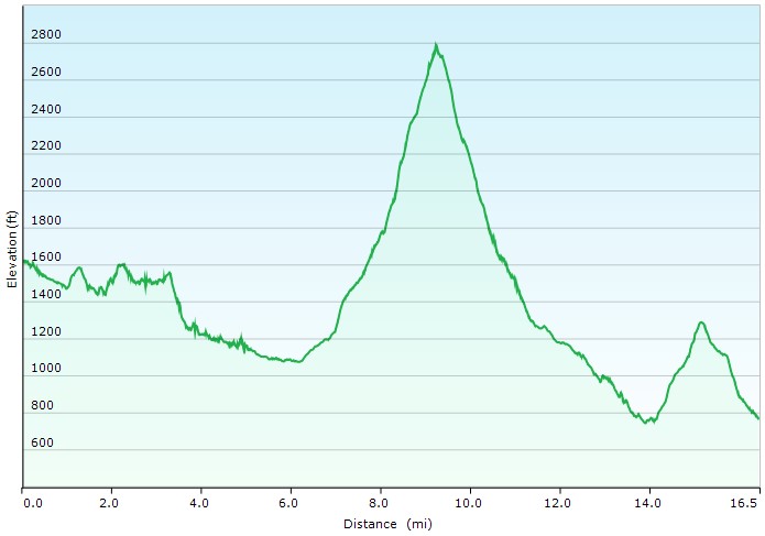
For this summer backpacking trip, I headed up to the Wild River Wilderness to create a 36 mile hiking loop with 10,000 feet of gross elevation gain by linking together the Appalachian trail with several other lesser used and more rugged trails in the White Mountain National Forest.
My June temperature range for this trip was between 35° and 85° with a chance of rain each day, but mostly during the night. Due to the wide temp range and the unpredictable weather typically encountered in the White Mountains, I packed in a puffy jacket and some ultralight rain gear for additional protection against the elements. This brought my pack’s base weight right up to around the 10 lb mark.
- Thank you to Upstart for sponsoring this trip. See how they can help you build your credit and get free of high interest debt at Upstart.com/Sintax
I went with my standard minimalist hammock camping setup for this trip. While I planned to stay at officially recognized campsites, I still wanted the ability to camp at a legal, but unofficial spot if the opportunity or need arose. Due to the dense vegetation and uneven ground found at upper elevations in the Whites, I’ve learned that a hammock is often the only realistic option in those types of conditions.
Water would be plentiful along the river portion of my loop, but would only be reliably available at Imp campsite during the ridge hike section, so I had to plan accordingly for that during the first half of my trip. The second half of my trip would have more water, but would be on more challenging trails. Notably, the Black Angel Trail, a rugged and minimally maintained wilderness trail, and the Highwater Trail, which suffered substantial washouts and haphazard re-routes due to storm damage from Hurricane Irene back in 2011.
Route Overview – WIld River Carter-Moriah Backpacking Loop – Sintax77
Full GPS track data, including campsites, etc, for this trip and many others can be downloaded on my Trip Data Page.
Trailhead Used: Rattle River Trailhead , 44°24’04.4″N 71°06’35.2″W
US Route 2, Shelburne, NH 03581
This is an easily accessible gravel parking lot with room for a dozen cars or so.
Trails Used, Day 1
- Rattle River Trail (Appalachian Trail South)
- Kenduskeag Trail (AT South)
- Carter-Moriah Trail (AT South)
- Camp at Imp Shelter Tentsite
- This site has a reliable water source, a large wooden shelter, bear box and tent platforms. I was able to easily hang my hammock over one of the platforms. There is an AMC caretaker and $15 fee from Memorial Day through Columbus Day. As per the USFS, there is no fee required outside of caretaker season.
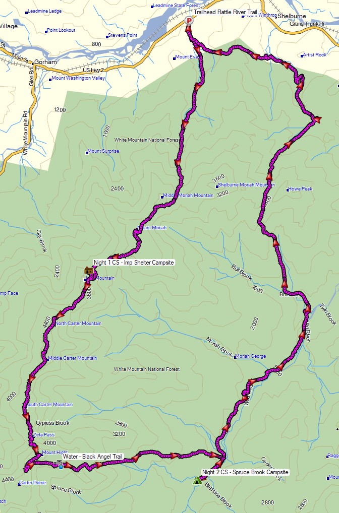
Day 1 Mileage: 8.4 miles
Day 1 Gross Elevation Gain: 3,809′
Day 1 Gross Descent: 1,396′
Day 1 Elevation Profile – Wild River Carter-Moriah Backpacking Loop – Sintax77
Trails Used, Day 2
- Carter-Moriah Trail (AT South)
- Black Angel Trail
- South on Wild River Trail
- Camp at Spruce Brook Tentsite
- Water is available at the river along the trail. Several graded tent spots are located about 150 yards up the hill from the trail. There is a large established fire pit located along the trail before heading up the trail to the tentsites. There used to be a shelter here as well, but it has been removed. On the upside, there is no AMC fee to camp here.
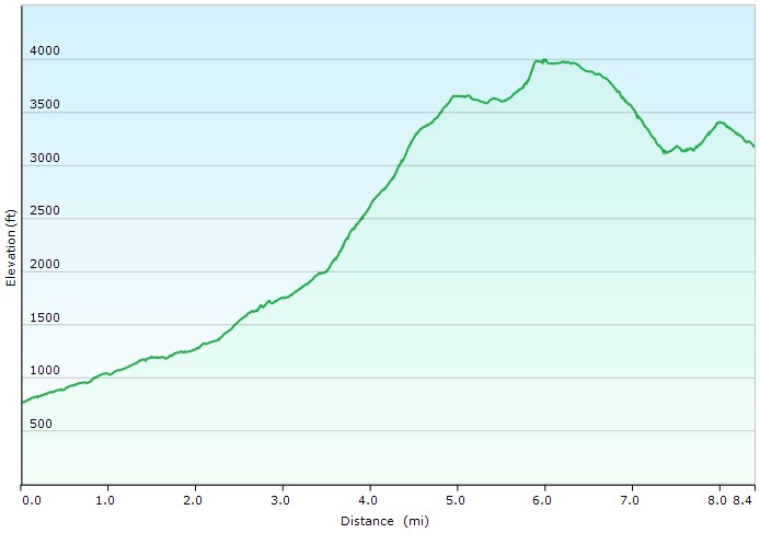
Day 2 Mileage: 11.3 miles
Day 2 Gross Elevation Gain: 2,983′
Day 2 Gross Descent: 4,439′
Day 2 Elevation Profile – Wild River Carter-Moriah Backpacking Loop – Sintax77
Trails Used, Day 3
- North on Wild River Trail
- Highwater Trail
- Shelburne Trail
- At intersection with Kenduskeag Trail, continue on Shelburne Trail.
- Unnamed Snowmobile Trails
- Okay, so here’s where I made the unfortunate gamble to avoid some elevation. I wouldn’t recommend this in warmer months. The unnamed trails I took ended up being snowmobile trails that aren’t really maintained with hiking in mind. They ended up having a ton of standing water on them and were basically a 3 mile long mosquito breeding ground. Do yourself a favor and take the Kenduskeag trail back up the ridge to the southern terminus of Rattle River Trail instead.
- Return to Rattle River Trail parking lot
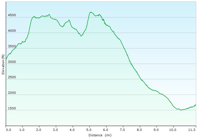
Day 3 Mileage: 16.5 miles
Day 3 Gross Elevation Gain: 3,147 feet
Day 3 Gross Descent: 3,992′
Day 3 Elevation Profile – Wild River Carter-Moriah Backpacking Loop – Sintax77
Grand Total Mileage: 36.2 Miles
Grand Total Gross Elevation Gain: 9,939′
Notable Backpacking Gear
- ULA Ohm 2.0 Backpack
- Dutchware Pack Cover
- Dutchware Gear Half-Wit Hammock
- Hammock Gear Phoenix 30 Underquilt
- Hammock Gear Burrow 40 Top Quilt
- Hammock Gear Dyneema Hex Tarp
- DIY Cat Can Alcohol Stove
- Vargo Windscreen Pot Stand
- Toaks 750ml Titanium Pot
- Sea to Summit Long Handled Spork
- Potable Aqua Water Purification Tablets with PA Plus
- Outdoor Research Helium Rain Jacket
- Outdoor Research Helium Rain Pants
- Outdoor Vitals Satu Adventure Pants
- La Sportiva Wildcat Trail Running Shoes
- Wright Socks (I love these for blister prevention, particularly in wet conditions).
- Nitecore NU25 Headlamp
- Spot X Satellite Messenger
- Casio ProTrek FR-30 Smartwatch
- Benchmade Bugout EDC Folding Knife
- Mountain House Backpacking Meals
- Baofeng UV-5R Radio

Camera Gear used for this episode