
3 days of Backpacking, Trekking Pole Tent Camping and Lean-to Shelter Camping on the Old Loggers Path.
FTC Disclosure: This post contains affiliate links, which means I may receive a commission for purchases made through some of my links.
For this 3 day, 2 night summer backpacking trip, I decided to revisit the OLP in Pennsylvania’s Loyalsock State forest. The OLP is a 27 mile backpacking loop along babbling brooks, waterfalls, hardwoods and hemlocks. I previously did this loop counter-clockwise as a solo hike a couple of years ago, but there was so much to soak in that I decided it would be worth hiking it again. This time I would hike it clockwise with my buddy Dave from Outdoor Vitals, who recently moved out to Pennsylvania from Utah.
Dave had never camped in a lean-to shelter before, so we targeted the Sprout Point shelter for our first night, followed by some tent camping along the confluence of Rock Run and Yellow dog run on the second night. This would also be my first time experimenting with an ultralight trekking pole tent, so I was looking forward to trying that out.
Our weather ranged from highs in the upper 70’s with fairly high humidity, and lows in the upper 60’s. This allowed me to save weight by packing a lightweight 40° quilt and leaving my extra warm clothing layers at home. There was a possibility of rain each day though, so I packed in full rain gear. I also brought a folding saw and some other comfort items, so my base weight was still right around 10 lbs despite the warm forecast.
Trail conditions on the OLP are a mix of nice flat dirt sections, punctuated by spurts of steep sections littered with Pennsylvania’s infamous rocks to keep you on your toes ; literally. Despite the occasional rough sections, the average daily gross elevation gain was only around 1,500 feet per day. Potential water sources are fairly plentiful on the Old Loggers Path, but the key word is potential. When I went before in spring, I got by with only carrying around 1 liter of water at a time. This time around things were very dry, so the only water sources we used were the two that are always flowing – Pleasant Valley Stream and the Rock Run / Yellow Dog Run confluence.
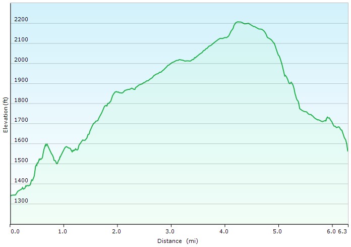
Route Overview – Old Loggers Path Clockwise Backpacking Loop – Sintax77
Trailhead Used: Masten Camp Parking Lot , 41°30’25.2″N 76°49’15.6″W
Pleasant Stream Rd, Canton, PA 17724
The parking area on Pleasant Stream Rd has room for several vehicles and is easily accessible via 2wd.
No permit is required for dispersed camping in the Loyalsock State Forest, so long as you are only camping one night at each campsite. You can find more information on the Loyalsock State Forest website here.
Full GPS track data, including campsites, water sources, etc, for this trip and many others can be downloaded on my Trip Data Page.
Trails Used, Day 1
- Cross the auto bridge to start clockwise on the orange blazed OLP trail
- Keep on following those orange blazes and stay aware of other old logging paths in the area that are not the OLP!
- Camp at Sprout Point Shelter
- This is a newly built three sided wood shelter with a firepit and nearby vista. Due to the dense vegetation, tent camping spots are limited, so we opted to stay in the shelter. This is a dry site, so we packed in enough water for the night and following morning.
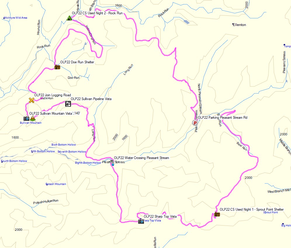
Day 1 Mileage: 4.9 miles
Day 1 Gross Elevation Gain: 909 feet
Day 1 Gross Elevation Descent: 402 feet
Day 1 Elevation Profile – Old Loggers Path Clockwise Backpacking Loop – Sintax77
Trails Used, Day 2
- Continue on the Old Loggers Path
- Take at break at Sharp Top Vista, arguably the best view on the loop.
- Refill water at the crossing of Pleasant Stream
- Note: This is the only water crossing on the loop that may pose a challenge after heavy rains. With our dry summer conditions we easily crossed it without even getting our feet wet.
- Catch some views from Sullivan Mountain
- Setup camp at Rock Run and Yellow Dog Run.
- There are multiple camping opportunities in this area for tents or hammocks with several pre-established fire rings and plenty of water.
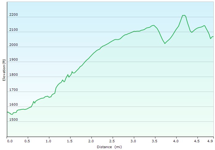
Day 2 Mileage: 15.5 miles
Day 2 Gross Elevation Gain: 2,262 feet
Day 2 Gross Elevation Descent: 2,991 feet
Day 2 Elevation Profile – Old Loggers Path Clockwise Backpacking Loop – Sintax77
Trails Used, Day 3
- Continue on the Old Loggers Path.
- Return to Masten Camp parking lot.
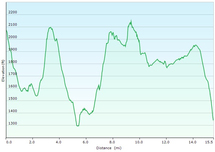
Day 3 Mileage: 6.3 miles
Day 3 Gross Elevation Gain: 1,103 feet
Day 3 Gross Elevation Descent: 881 feet
Day 3 Elevation Profile – Old Loggers Path Clockwise Backpacking Loop – Sintax77
Grand Total Mileage: 26.7 Miles
Grand Total Gross Elevation Gain: 4,274 feet
You can also find lots of good info about the OLP here on the MidAtlanticHikes.com
Notable Backpacking Gear
- ULA Ohm 2.0 Backpack
- Outdoor Vitals Fortius 1p Trekking Pole Tent
- Outdoor Vitals Dominion 1p Tent
- Outdoor Vitals Inflatable Pillow
- Hammock Gear Burrow 40 Top Quilt
- Unigear Sleeping Pad
- DIY Cat Can Alcohol Stove
- Vargo Windscreen Pot Stand
- Toaks 750ml Titanium Pot
- Titanium Long Handled Spork
- Potable Aqua Water Purification Tablets with PA Plus
- Katadyn BeFree Water Filter
- Outdoor Research Helium III Rain Pants
- Outdoor Vitals Tushar Rain Jacket
- Outdoor Vitals Altitude Sun Hoodie
- Outdoor Vitals Satu Adventure Pants
- La Sportiva Wildcat Trail Running Shoes
- Benchmade Bugout EDC Folding Knife
- Nitecore NU25 Headlamp
- Spot X Satellite Messenger
- Nebula Capsule Projector
- Peak Refuel Backpacking Meals

FTC Disclosure: This post contains affiliate links, which means I may receive a commission for purchases made through some of my links.