Deep Woods Camping & Finding a Cessna 414

FTC Disclosure: This post contains affiliate links, which means I may receive a commission for purchases made through some of my links.

For this backpacking trip, we hiked into the Cranberry Wilderness in search of a twin engine private plane that crashed in 1995 and went missing for 6 years, deep in the forests of a remote West Virginia mountaintop.  There was also a hiker who went missing here back in 2011.

For sleep and shelter, Frank and I both decided to pack in our Amok Draumr Hammock camping systems. This would allow us to get a comfortable camping setup even if we were forced to camp in one of the mossy rock fields that are often encountered along mountain ridges in the Cranberry Wilderness.  A detailed gear list can be found at the bottom of this post.

On the morning of November 28th, 1995, a Cessna 414, tail number N28901 took off from Braxton County Airport in Sutton, West Virginia headed for Lynchburg Regional, Virginia.  After encountering low visibility due to foggy conditions, the lone pilot contacted air traffic control to request an IFR (instrument flight rules) flight plan in order to continue navigating the approaching mountainous terrain.  After a period of apparent poor communications, possibly due to a radio issue, ATC lost contact with the pilot.  Transponder signals ceased not long after the last communication, and the plane was never heard from or seen again until it was spotted from the air over six years later.

More info on N28901 can be found in this copy of the NTSB report.

Cranberry Wilderness Cessna 414 Search Route Overview - Sintax77

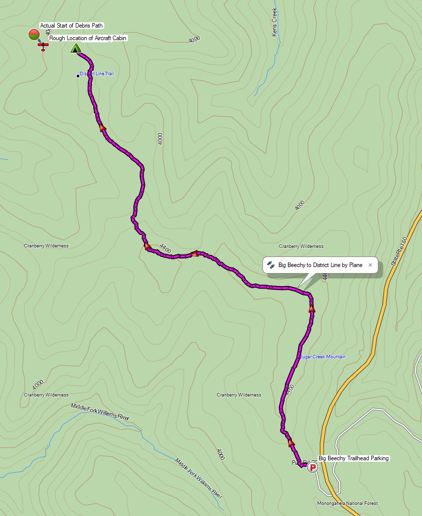
Route Overview – Cranberry Wilderness Cessna 414 Backpacking Trip  – Sintax77

No permit is required to backcountry camp in the Monongahela National Forest.

Full GPS track data, including campsites, etc, for this trip and many others can be downloaded on my Trip Data Page.

Trailhead Used: Big Beechy Trailhead, 38°17’44.2″N 80°14’55.7″W
Highland Scenic Hwy, Minnehaha Springs, WV 24954

Continue reading

Winter Camping and Finding a Plane Crash – Mt Success DC-3

Backpacking & Solo Winter Camping in search of a 1954 commercial airline crash near the summit of Mt Success in the White Mountains.

FTC Disclosure: This post contains affiliate links, which means I may receive a commission for purchases made through some of my links.

For this 3 day, 2 night camping trip, I headed up to a lesser traveled corner of New Hampshire’s White Mountain National Forest for some snowshoeing, camp cooking, and bit of New England aviation history.

My goal for this adventure was to find the resting place of Northeast Airlines Flight 792, which crashed on approach to Berlin Municipal Airport during inclement weather on November 30th, 1954. It made contact in the dense trees near the summit of Mt Success at an elevation of 3,390 feet.  More information on the details of Flight 792 and the circumstances of it’s survivors can be found in this copy of the official Accident Investigation Report

The 6.5 mile hike to get there would require a gross elevation gain of roughly 3,700 feet on potentially unbroken trail in deep snow.  The final portion of the hike would be an unofficial bushwhack through dense trees and snow.  For this reason, I chose to break up the approach up by setting up camp at roughly the halfway point along Gentian Pond and the nearby lean-to shelter with sweeping views of the Carter-Moriah mountain range.  After camping for the night, I would head up to the top of Mt Success, the first peak of the Mahoosuc Range and the Appalachian Trail’s gateway to Maine. After a few miles and a couple thousand feet of ascent with my trusty snowshoes, I would leave the trail behind in search of the DC-3.

Mt Success DC-3 Winter Backpacking Trip – Route Overview

No permit is required to backcountry camp in the White Mountains, but some locations do require a daily, weekly, or annual pass.  The parking area for this trip did not require a parking fee as of January 2021.

Full GPS track data, including campsites, water sources, etc, for this trip and many others can be downloaded on my Trip Data Page.

Trailhead Used: Austin Brook Trailhead on North Road,  44°24’45.1″N 71°04’05.4″W
North Rd, Shelburne, NH 03581

Continue reading