
Backpacking & Solo Winter Camping in search of a 1954 commercial airline crash near the summit of Mt Success in the White Mountains.
FTC Disclosure: This post contains affiliate links, which means I may receive a commission for purchases made through some of my links.
For this 3 day, 2 night camping trip, I headed up to a lesser traveled corner of New Hampshire’s White Mountain National Forest for some snowshoeing, camp cooking, and bit of New England aviation history.
My goal for this adventure was to find the resting place of Northeast Airlines Flight 792, which crashed on approach to Berlin Municipal Airport during inclement weather on November 30th, 1954. It made contact in the dense trees near the summit of Mt Success at an elevation of 3,390 feet. More information on the details of Flight 792 and the circumstances of it’s survivors can be found in this copy of the official Accident Investigation Report
The 6.5 mile hike to get there would require a gross elevation gain of roughly 3,700 feet on potentially unbroken trail in deep snow. The final portion of the hike would be an unofficial bushwhack through dense trees and snow. For this reason, I chose to break up the approach up by setting up camp at roughly the halfway point along Gentian Pond and the nearby lean-to shelter with sweeping views of the Carter-Moriah mountain range. After camping for the night, I would head up to the top of Mt Success, the first peak of the Mahoosuc Range and the Appalachian Trail’s gateway to Maine. After a few miles and a couple thousand feet of ascent with my trusty snowshoes, I would leave the trail behind in search of the DC-3.
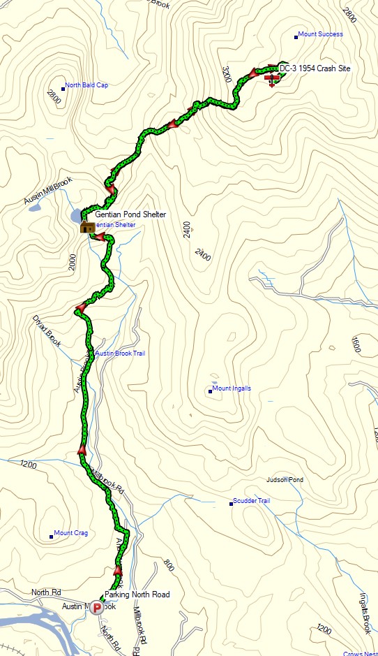
Mt Success DC-3 Winter Backpacking Trip – Route Overview
No permit is required to backcountry camp in the White Mountains, but some locations do require a daily, weekly, or annual pass. The parking area for this trip did not require a parking fee as of January 2021.
Full GPS track data, including campsites, water sources, etc, for this trip and many others can be downloaded on my Trip Data Page.
Trailhead Used: Austin Brook Trailhead on North Road, 44°24’45.1″N 71°04’05.4″W
North Rd, Shelburne, NH 03581
There is a small parking lot with room for 2 or 3 cars located directly across the street from the Austin Brook trailhead. No parking fee or permit is required.
Trails Used, Day 1
- North on Austin Brook Trail
- Camp at Gentian Pond Shelter
- This is a beautiful two level wooden lean-to with one of the best views from inside that I’ve ever seen in a backpacking shelter. There is a bear bin out back, a composting privy, and easily obtainable water available by the nearby pond. There are several tent platforms behind the shelter as well. No fires are permitted.
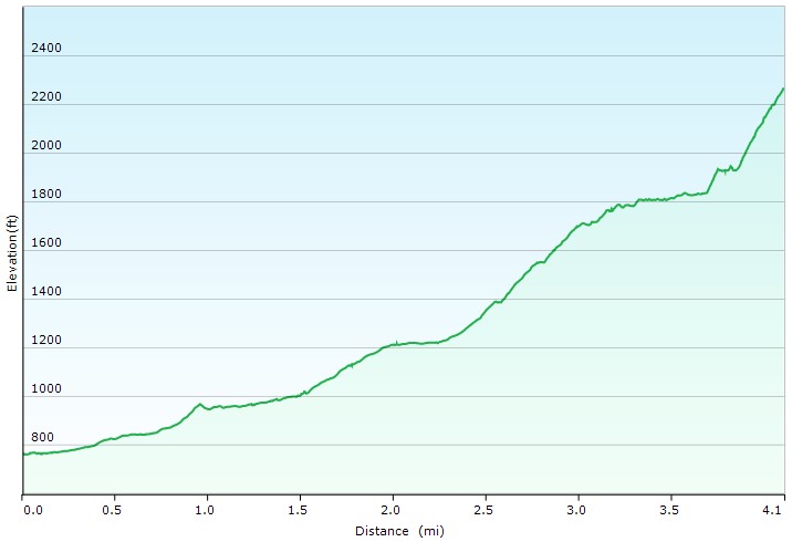
Day 1 Elevation Profile – Mt Success DC-3 Winter Backpacking Trip – Sintax77
Day 1 Mileage: 3.5 miles
Day 1 Gross Elevation Gain: 1,582 feet
Trails Used, Day 2
- Appalachian Trail Northbound
- Bushwhack towards the DC-3 plane crash site
- The ground was covered with snow when I was there, but in warmer months there should be a faint, but visible herd path going into the woods in the open area just before the summit of Mt Success.
- Once you’re back in the woods, look out for yellow blazes indicating the Appalachian trail boundary. The DC-3 is coincidentally right along this boundary. In my case, the snow on the trees and darkness limited my ability to follow these, but they should be more obvious in the daytime without fresh snow conditions.
- Appalachian Trail Southbound
- Return to camp at Gentian Pond Shelter
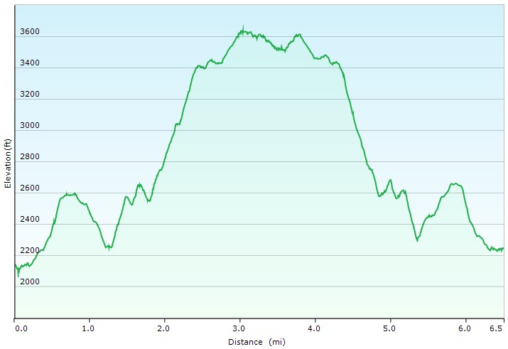
Day 2 Elevation Profile – Mt Success DC-3 Winter Backpacking Trip – Sintax77
Day 2 Mileage: 6.5 miles
Day 2 Gross Elevation Gain: 3,018 feet
Trails Used, Day 3
- South on Austin Brook Trail
- Return to the North Road parking lot.
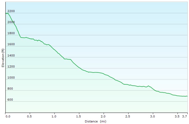
Day 3 Elevation Profile – Mt Success DC-3 Winter Backpacking Trip – Sintax77
Day 3 Mileage: 3.5 miles
Day 3 Gross Elevation Gain: 75 feet
Grand Total Mileage: 13.5 Miles
Grand Total Gross Elevation Gain: 4,675 feet
Notable Backpacking Gear
- Fjallraven Kajka 75 Backpack
- Hammock Gear Burrow 0 Top Quilt
- Amok Fjol XL Winterlight Sleeping Pad
- Dutchware UP Booties
- Toaks 750ml Titanium Pot
- Aeropress Go Portable Travel Coffee Press
- Optimus Polaris Optifuel Stove
- MSR Flex Skillet
- Light My Fire Mini Fire Steel Striker
- Sea to Summit Long Handled Spork
- Potable Aqua Water Purification Tablets with PA Plus
- Outdoor Research MicroGravity AscentShell Jacket
- Military Fleece Jacket
- Outdoor Vitals Adventure Jacket, Loftek version
- Outdoor Vitals Satu Adventure Pants
- Hardshell Pants – Military ECWCS Gen III Trousers
- Solomon Toundro Pro CSWP Boot
- Dutchware Folding Sit Pad
- Byer of Maine Trilite Camp Stool
- Nitecore NU25 Headlamp
- Casio ProTrek F30 Smartwatch
- Benchmade Bugout EDC Folding Knife
- Peak Refuel Backpacking Meals

Camera and Nav Gear used for this episode