
Winter Camping in a Snow Storm on North Fork Mountain, West Virginia.
FTC Disclosure: This post contains affiliate links, which means I may receive a commission for purchases made through some of my links.
For this winter backpacking trip, we set out to do some overnight camping in the Monongahela National Forest by an awesome vista known as Chimney Top during the last week of January. The weather forecast showed the potential for a snow storm to land some time between the first night and the morning of the next day, so we decided to keep our mileage fairly low and laid back. Temperatures were projected to be fairly steady in the low to mid 20’s Fahrenheit.
Our initial climb up to the ridge would require a gross elevation gain of roughly 2,000 feet over the course of two miles. Once we got to the ridge, we would be afforded with seemingly endless mountain views overlooking the Potomac River, New Creek Mountain, and Dolly Sods in the distance. After following the ridge for a while we would start to look for campsite opportunities.
Besides the quick elevation gain, our main challenge on this trip would be water. There is only one semi reliable water source on the entire 25 mile length of the North Fork Trail, and it’s located right around the half way point at 12.5 miles. We wouldn’t be going that far, so we would have to pack in all of our water for drinking and cooking. If the snow storm had hit prior to our arrival, we would have had the advantage of melting snow. With the ground dry and free of snow upon our arrival, we decided to pack in 1 gallon (4 liters) of water per person.
For shelter, Frank and James went with tent camping in individual tents, while I chose to go with a hammock camping setup. With this mix of shelters, we hoped to be able to find a decent spot to camp on the ridge with some nice mountain views.
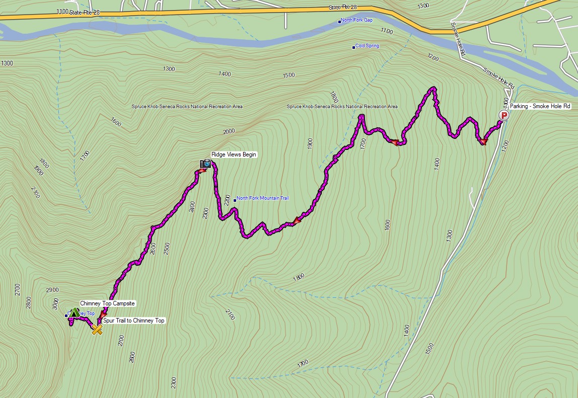
Route Overview – North Fork Mountain Trail Chimney Top – Sintax77
No permit is required to backcountry camp in the Monongahela National Forest.
Full GPS track data, including campsites, etc, for this trip and many others can be downloaded on my Trip Data Page.
Trailhead Used: North Fork Mountain Trailhead, Northern End
38°58’53.0″N 79°13’53.8″W
Smoke Hole Rd, Cabins, WV 26855
This is a small parking lot with room for several cars that is easily accessible via a paved road. No parking fee or permit is required.
Trails Used, Day 1
- West on North Fork Mountain Trail
- Turn right (west) on the spur trail to Chimney Top
- This is an unofficial spur trail to the Chimney Top rock formation and vista, although it is marked on some maps. The intersection was marked by a small pile of rocks when we went, but that may or may not be there in the future.
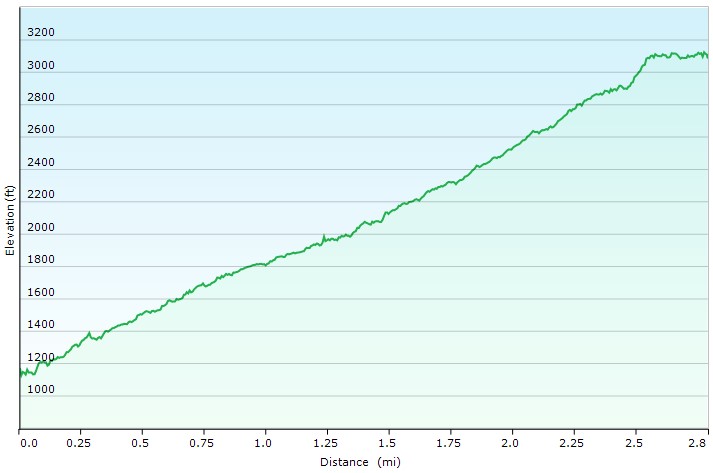
Day 1 Elevation Profile – North Fork Chimney Top Winter Backpacking Trip – Sintax77
Day 1 Mileage: 2.5 miles
Day 1 Gross Elevation Gain: 2,096 feet
Trails Used, Day 2
- Retrace yesterday’s route.
- Return to Smoke Hollow Rd trailhead.
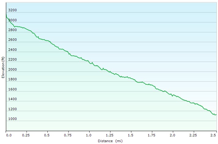
Day 2 Elevation Profile – North Fork Chimney Top Winter Backpacking Trip – Sintax77
Day 2 Mileage: 2.5 miles
Day 2 Gross Elevation Gain: 55 feet
Grand Total Mileage: 5 Miles
Grand Total Gross Elevation Gain: 2,151 feet
Notable Backpacking Gear
- Fjallraven Kajka 75 Backpack
- Amok Draumr XL Hammock
- Amok Borg Tarp
- Amok Fjol XL Winterlight Sleeping Pad (for hammock and tent)
- Hammock Gear Burrow 0 Top Quilt (in hammock)
- Kelty Salida 2 Person Tent
- Kelty Cosmic 0 Down Sleeping Bag (For tent)
- Dutchware Xenon 2 Person Tarp
- MalloMe Camp Cookset
- Aeropress Go Portable Travel Coffee Press
- Optimus Polaris Optifuel Stove (running on white gas)
- Light My Fire Mini Fire Steel Striker
- Zippo Classic Lighter
- Sea to Summit Long Handled Spork
- Outdoor Research MicroGravity AscentShell Jacket
- Military Fleece Jacket
- Outdoor Vitals Adventure Jacket, Loftek version
- Outdoor Vitals Satu Adventure Pants
- Hardshell Pants – Military ECWCS Gen III Trousers
- Solomon Toundro Pro CSWP Boot
- Byer of Maine Trilite Camp Stool
- Nitecore NU25 Headlamp
- Casio ProTrek F30 Smartwatch
- Benchmade Bugout EDC Folding Knife
- Surplus MRE’s (Meal Ready to Eat)
- Mountain House Sausage Biscuits & Gravy

Camera and Nav Gear used for this episode