
Hiking, Backpacking and an attempt at Tent Camping in the Rain in Virginia’s George Washington National Forest.
FTC Disclosure: This post contains affiliate links, which means I may receive a commission for purchases made through some of my links.
For this overnight backpacking trip, Sara and I decided to do some summer backpacking with our dog on a section of Great North Mountain, a 50 mile long mountain ridge that runs along the border of West Virginia and Virginia.
Despite the threat of a quickly approaching storm, we decided to forge ahead with a modest 3 day, 7 mile backpacking trip. Our plan was to keep the itinerary relatively simple in hopes that we could get to camp in time to beat the rain. And then we ran into a slight complication. Actually, it wasn’t slight at all. It was quite possibly the biggest backpacking mistake I’ve ever made…
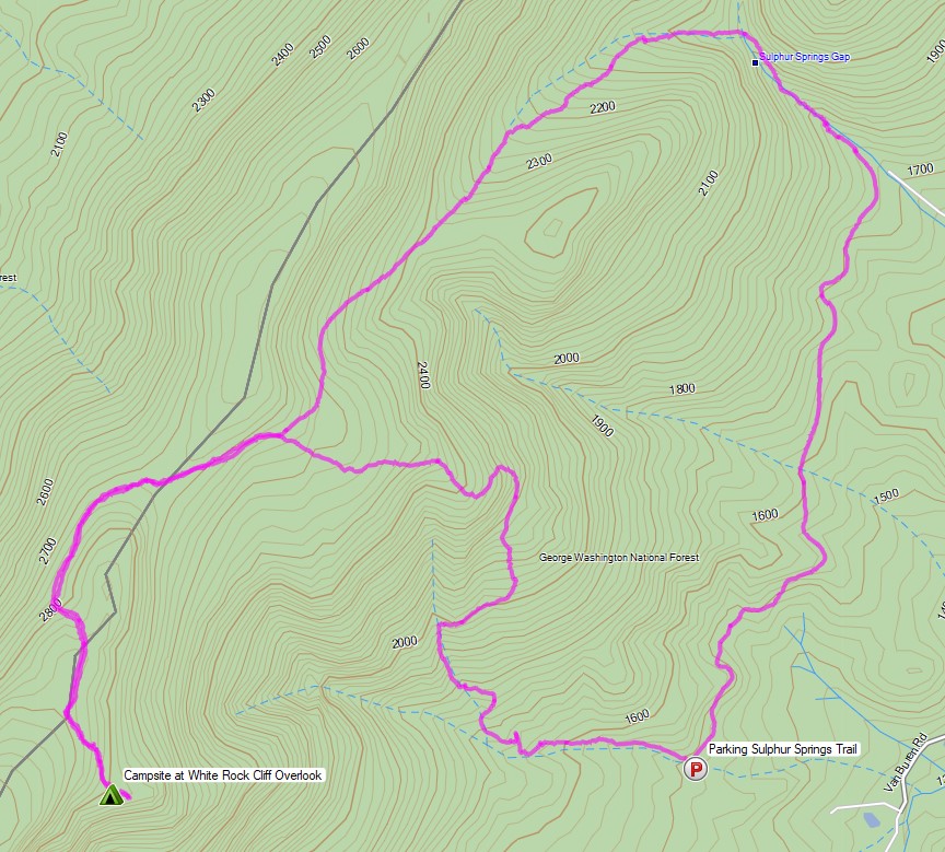
White Rock Cliff Loop Virginia – Route Overview – Sintax77
There is no parking fee or backcountry camping permit required for this section of the George Washington and Jefferson National Forest. More details regarding dispersed camping can be found on the official GWJNF website here.
Full GPS track data, including campsites, water sources, etc, for this trip and many others can be downloaded on my Trip Data Page.
This trip video was sponsored by RevolutionRace. Use code 15sintax to get 15% off their entire Amazon store site until 9/11/21 here.
Trailhead Used: Sulphur Springs Parking Area Forest Road 1725
38°58’31.4″N 78°34’03.5″W
FR1725, Maurertown, VA 22644
The Sulphur Springs parking area is located on a narrow gravel road with room for 3 or 4 vehicles.
Trails Used, Day 1
- Hike north on the gravel road towards the gate.
- Just past the gate, turn left (west) onto the unnamed trail running along the creek.
- Right (north) onto the Tuscarora Trail
- Left (west) at the intersection to remain on the Tuscarora Trail.
- Left (southeast) on the white blazed White Rock Cliff Overlook trail.
- Camp near White Rock Overlook (also known as Opa Overlook)
- This is a large campsite with 2 fire rings in the main area, and a third tucked within the trees in a separate small clearing that could accommodate a single person tent in a pinch. The main area has room for multiple tents or hammocks. This is a dry site, so make sure to pack in enough water.
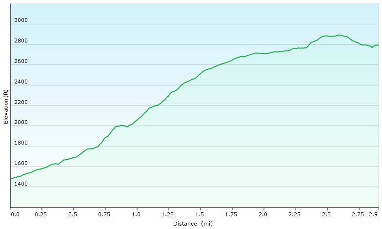
Day 1 Elevation Profile – White Rock Cliff Loop Virginia – Sintax77
Day 1 Mileage: 3 miles
Day 1 Gross Elevation Gain: 1,451 feet
Day 1 Gross Descent: 141 feet
Trails Used, Day 2
- Head back out on White Rock Cliff Overlook Trail
- Right (north) on Tuscarora Trail
- Straight (northeast) on Sulphur Springs Trail
- Right (south) on the forest road.
- Return to parking area.
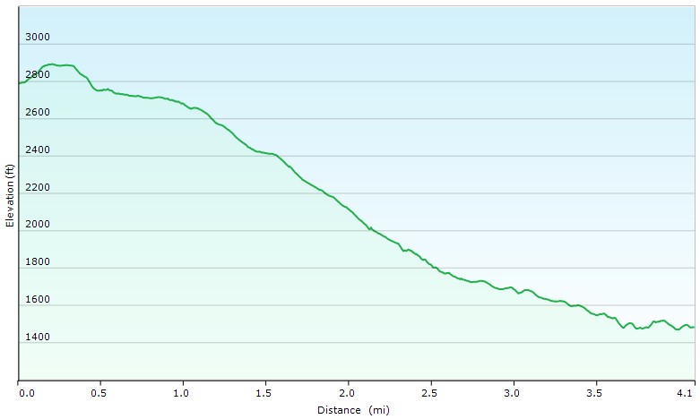
Day 2 Elevation Profile – White Rock Cliff Loop Virginia – Sintax77
Day 2 Mileage: 4 miles
Day 2 Gross Elevation Gain: 254 feet
Day 2 Gross Descent: 1,559 feet
Grand Total Mileage: 7 Miles
Grand Total Gross Elevation Gain: 1,705 feet
Notable Camping Gear
- Sara’s ULA Ohm 2.0 Backpack
- My Fjallraven Kajka 75 Backpack
- Dutchware Xenon 2 Person Tarp
- Hammock Gear Burrow 40 Top Quilt
- Sara’s Amok Fjol XL Winterlight Sleeping Pad
- Sintax77’s Unigear Sleeping Pad
- Sara’s Revolutio Race Silence Pro Shell Jacket
- Shawn’s RevolutionRace Campfire Shirt
- RevolutionRace Men’s GP Pants
- RevolutionRace Women’s GP Pants
- MalloMe Camp Cookset
- BSR Ultralight Canister Stove
- Light My Fire Mini Fire Steel Striker
- Sea to Summit Alpha Light Long Spork
- Vargo 450ml Mug
- La Sportiva Wildcat Trail Running Shoes
- Nitecore NU25 Headlamp
- Nite Ize Lantern
- Casio ProTrek F30 Smartwatch
- Sangean Radio DT-400W weather band radio
- Benchmade Bugout EDC Folding Knife
- Bahco Laplander Folding Saw
- Packit Gourmet Backpacking Meals


Camera and Nav Gear used for this episode