
3 days of Backpacking, Thunderstorms & Hammock Camping in Heavy Rain on a section of Pennsylvania’s Black Forest Trail.
For this adventure, I headed out for a 3 day, 2 night solo backpacking trip in Pennsylvania’s Tiadaghton State Forest. The full Black Forest Trail is a rugged 43 mile loop with 8,550′ of elevation gain that I’ve done in the past and really enjoyed.
Facing a July forecast in the triple digits with thunderstorms, and the fact that my last solo hike was a pretty intense one, I decided to scale the mileage back this time. My general plan was to simply go into the woods and use the network of connector trails to come up with a route on the fly, based on how the weather played out from day to day.
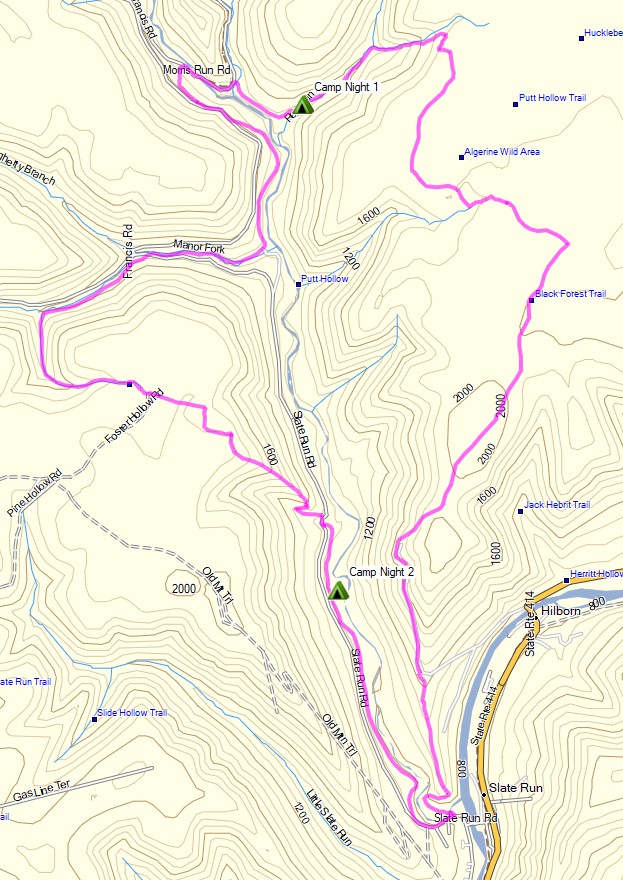
Black Forest Trail Short Loop – Route Overview – Sintax77
If you’re interested in the details of the full Black Forest Loop, along with downloadable GPS data, you can find that in my previous post and trip video here.
I also highly recommend the Black Forest Trail Guidebook and Map
Trailhead Used: Pine Creek Rail Trail Access Area by Wolfe’s General Store
41°28’15.6″N 77°30’05.8″W
Slate Run, PA 17769
The trailhead is on the other side of the auto bridge, behind the Hotel Manor inn / pub. Parking immediately at the trailhead is for day use only. No overnight parking is permitted in the hotel’s parking lot by the actual trailhead.
Trails Used Day 1
- Park at the Slate Run Rail Trail parking lot
- Head over the auto bridge and make a right.
- Begin the loop at the Black Forest Trailhead, located in the lot behind Hotel
- Manor.
- Black Forest Trail
- Setup camp along Red Run Creek on the Black Forest Trail
- This is a large campsite with a fire ring and room for several tents or hammocks located right by the creek. This is the first water source I encountered all day. According to the guide book, there is a spring on the ridge about 2.75 miles in, but I didn’t notice it on my hike.
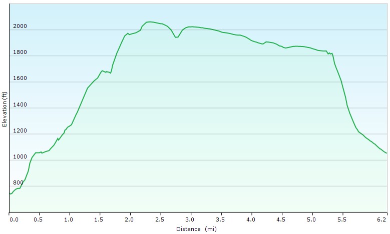
Day 1 Elevation Profile – Black Forest Trail Short Loop – Sintax77
Day 1 Mileage: 6 miles
Day 1 Gross Elevation Gain: 1,499′
Day 1 Gross Descent: 1,193′
Trails Used Day 2
- Continue on the Black Forest Trail
- Old Supply Trail (this shortcut leaves the BFT shortly after reaching Francis Rd)
- Reconnect with the Black Forest Trail
- BFT crosses Slate Run Road
- Setup camp along Slate Run Creek
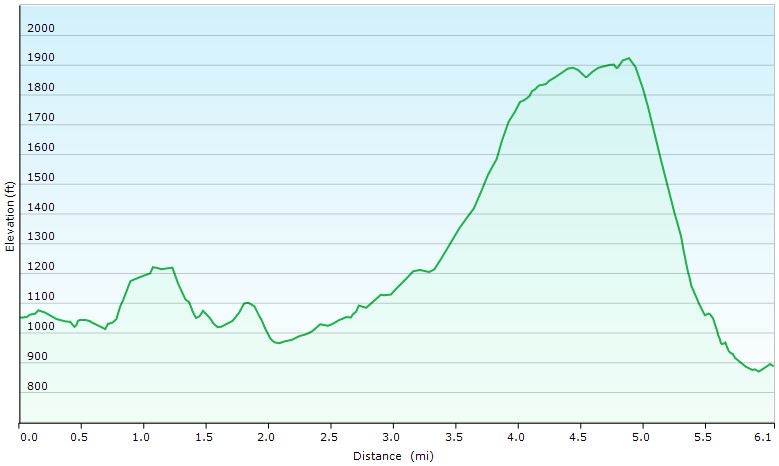
Day 2 Elevation Profile – Black Forest Trail Short Loop – Sintax77
Day 2 Mileage: 6 miles
Day 2 Gross Elevation Gain: 1,430′
Day 2 Gross Descent: 1,594′
Day 3
Continue on the Black Forest Trail
Return to the Slate Run Rail Trail Recreation Area Parking Lot
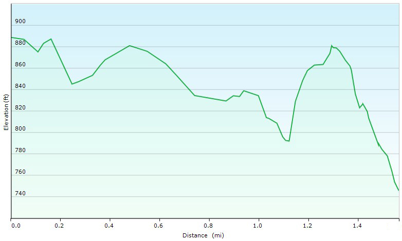
Day 3 Elevation Profile – Black Forest Trail Short Loop – Sintax77
Day 3 Mileage: 2 miles
Day 3 Gross Elevation Gain: 152′
Day 3 Gross Descent: 295′
Grand Total Mileage: 14 miles
Grand Total Gross Elevation Gain: 3,081
Notable Backpacking Gear
- ULA Ohm 2.0 Backpack
- Dutchware Pack Cover
- Dutchware Gear Chameleon Hammock with Beetle Buckle Suspension
- Hammock Gear Burrow 40 Top Quilt
- Hammock Gear Phoenix 30 Underquilt
- Hammock Gear Dyneema Hex Tarp
- DIY Cat Can Alcohol Stove
- Vargon Aluminum Windscreen
- Light My Fire Mini Fire Steel Striker
- Toaks 750ml Titanium Pot
- Sea to Summit Long Handled Spork
- Potable Aqua Water Purification Tablets with PA Plus
- Outdoor Research Helium III Rain Jacket
- Outdoor Vitals Satu Adventure Pants
- La Sportiva Wildcat Trail Running Shoes
- Nitecore NU25 Headlamp
- Benchmade Bugout EDC Folding Knife
- Casio ProTrek F-30 Smartwatch
- Packit Gourmet Backpacking Meals
- Spot X Satellite Messenger

Camera Gear used for this episode