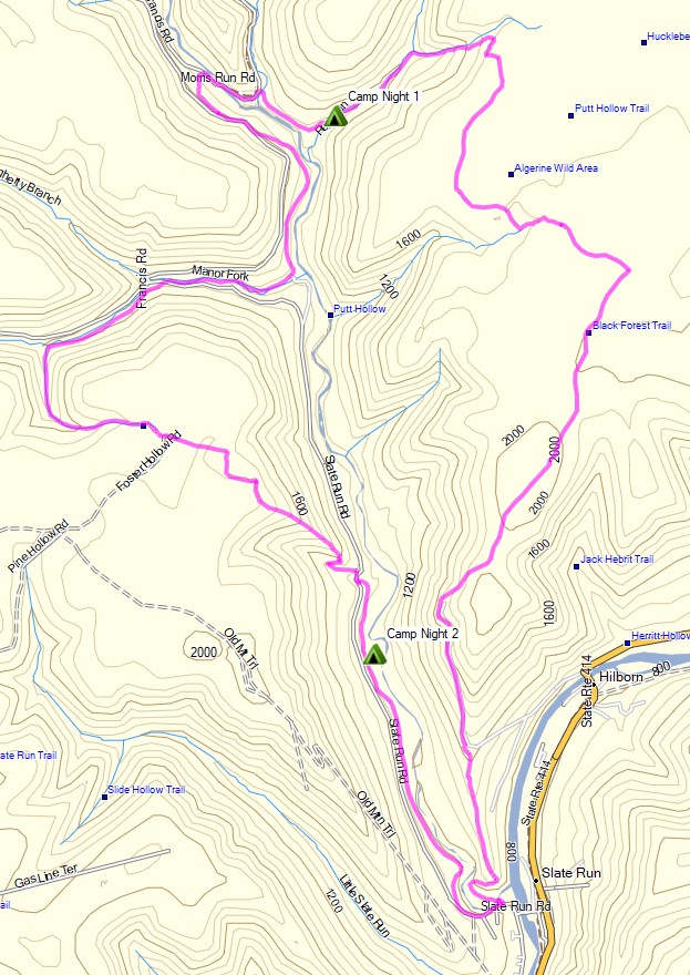
3 days of Backpacking, Thunderstorms & Hammock Camping in Heavy Rain on a section of Pennsylvania’s Black Forest Trail.
For this adventure, I headed out for a 3 day, 2 night solo backpacking trip in Pennsylvania’s Tiadaghton State Forest. The full Black Forest Trail is a rugged 43 mile loop with 8,550′ of elevation gain that I’ve done in the past and really enjoyed.
Facing a July forecast in the triple digits with thunderstorms, and the fact that my last solo hike was a pretty intense one, I decided to scale the mileage back this time. My general plan was to simply go into the woods and use the network of connector trails to come up with a route on the fly, based on how the weather played out from day to day.
Black Forest Trail Short Loop – Route Overview – Sintax77
Backpacking on a Section of Pennsylvania’s Blcak Forest Trail.
Mike and I get Covid Cabin Fever and head out for a hammock camping & backpacking trip on a section of Pennsylvania’s Black Forest Trail in Tiadaghton State Forest with some great views of Pine Creek and the “Pennsylvania Grand Canyon”. We also pay a little visit to the cabin on the way back, for some camp chores and relaxation.
FTC Disclosure: This post contains affiliate links, which means I may receive a commission for purchases made through these links.
Trailhead Used
End of Naval Run Road
Slate Run, PA 17769
41°27’29.7″N 77°30’57.5″W
Join me for 3 days of Hiking, Hammock Camping & Backpacking on Pennsylvania’s Black Forest Trail.
For this adventure, I’ll be doing a 3 day, 2 night solo backpacking trip in Pennsylvania’s Tiadaghton State Forest. The Black Forest Trail is a 42 – 43 mile loop (depending on where you park and start from) with a total elevation gain of 8,550′.
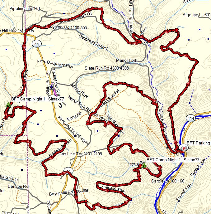
Black Forest Trail Route Overview – Sintax77
GPS Data for this trip and many others can be found on my Trip Data Page. Includes full track data for each day, and way-points for campsites used / observed along the loop.
I also highly recommend the Black Forest Trail Guidebook and Map. I found the mile by mile information provided and overall quality to be great and very helpful.
Trailhead Used: Pine Creek Rail Trail Access Area behind Wolfe’s General Store – 41°28’15.6″N 77°30’05.8″W Trailhead is on the other side of the auto bridge, behind the Hotel Manor inn / pub. Parking immediately at the trailhead is for day use only. No overnight parking is permitted in the hotel’s parking lot by the actual trailhead.
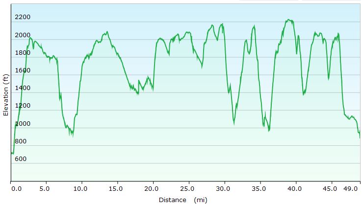
Black Forest Trail Full Loop Elevation Profile
Day 1
Park at the Slate Run Rail Trail parking lot
Head over the auto bridge and make a right.
Begin the loop at the Black Forest Trailhead, located in the lot behind Hotel Manor.
Head Counter Clockwise on the Black Forest Trail
Setup camp at an unestablished spot about a quarter mile past the crossing of Dyer Branch
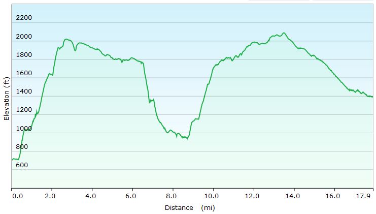
Black Forest Trail Day 1 Elevation Profile- Sintax77
Day 1 Mileage: 16 miles Day 1 Gross Elevation Gain: 2,989′
Day 2
Continue Counter-Clockwise on the Black Forest Trail
Setup camp at an establish spot along Naval Run creek.
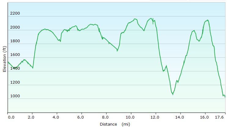
Black Forest Trail Day 2 Elevation Profile- Sintax77
Day 2 Mileage: 15 miles Day 2 Gross Elevation Gain: 3,182′
Day 3
Continue Counter-Clockwise in the Black Forest Trail
Return to the Slate Run Rail Trail Recreation Area Parking Lot
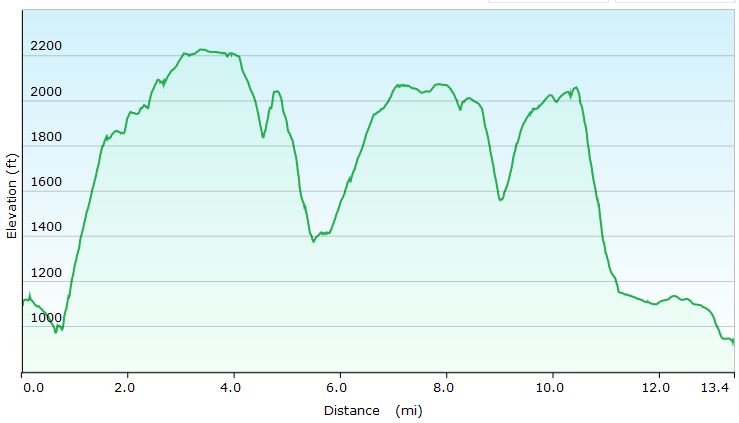
Black Forest Trail Day 3 Elevation Profile- Sintax77
Day 3 Mileage: 13 Day 3 Gross Elevation Gain: 2,953′

 . I found the mile by mile information provided and overall quality to be great and very helpful.