
3 Days of Hiking, Backpacking, & Rainy Hammock Camping in the Cranberry Wilderness using the Amok Draumr XL Hammock.
For this 3 day, 2 night spring backpacking trip, I’ll be hiking a 20 mile loop in West Virginia’s Cranberry Wilderness, part of the larger Monongahela National Forest. The specific area for this hike, located between the Williams River and the Cranberry River, is commonly referred to as the Cranberry Backcountry.
Each of the 3 days will be comprised of three different “vibes”. Day one will mostly be a lowlands hike in the woods, day two will be primarily along the the beautiful Cranberry River, and day three will be a mossy, higher elevation ridge hike along Kennison Mountain.
With a new Amok Fjol XL tarp in hand to thwart the forecast of rain, each night will be spent hammock camping and testing the new Amok Draumr XL hammock, which Amok kindly sent for evaluation.
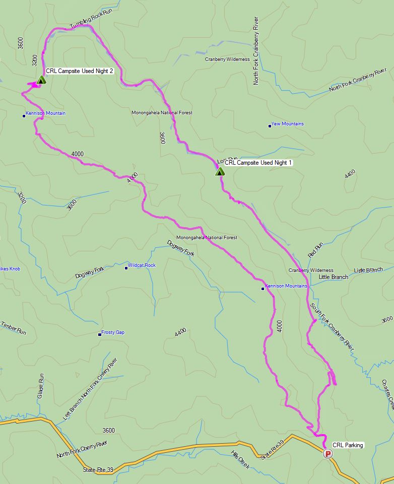
Route Overview Cranberry River Loop – Sintax77
No permit is required to camp in the Cranberry Wilderness, but there are rules and regulations regarding backcountry camping. You can find more information on the USFS Cranberry Wilderness website here.
Full GPS track data, including campsites, water sources, etc, for this trip and many others can be downloaded on my Trip Data Page.
Trailhead Used: Kennison Mountain Trailhead Parking Lot, N38° 11.113′ W80° 16.837′
Hillsboro, WV 24946
Kennison Mountain Trailhead parking area has room for a half dozen dozen or so vehicles. No parking fee or permit required. Loop begins from the parking lot side of the road.
Trails Used, Day 1
- Begin at the Kennison Mountain Trail Parking Lot
- At the intersection, head right (northeast) on the South Fork Trail
- At the fire road, depart the South Fork Trail and head left (northwest) on the road.
- Camp along the Cranberry River (1 mile after the bridge and South Fork Shelter)
- This is a medium sized camping spot with space for multiple tents or hammocks. There’s an established fire ring with rocks for camp stoves, etc. It’s located right along the river, so there is no need to pack in water. If taken, there is another option one tenth of a mile up on the right, where Lost Run meets the Cranberry River.
Day 1 Mileage: 6 miles
Day 1 Gross Elevation Gain: 217 feet
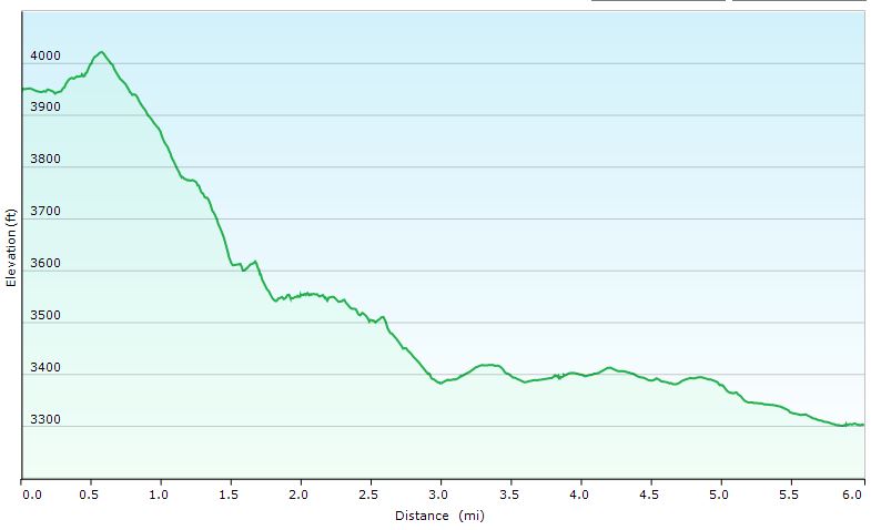
Day 1 Elevation Profile – Cranberry River Loop
Trails Used, Day 2
- Continue northwest on the fire road.
- Camp along the banks of Cranberry River, near House Log Shelter
- This is a large camping area with multiple tents or hammocks. There are spots to camp right by the shelter, or if it’s busier,, there are more options along the river, a few hundred yards downstream from the shelter. Established fire rings are at those locations, as well as by the shelter, which also has two picnic bench and a nearby privy. All of these spots are right along the river, so there is no need to pack in water.
Day 2 Mileage: 5 miles
Day 2 Gross Elevation Gain: 207 feet
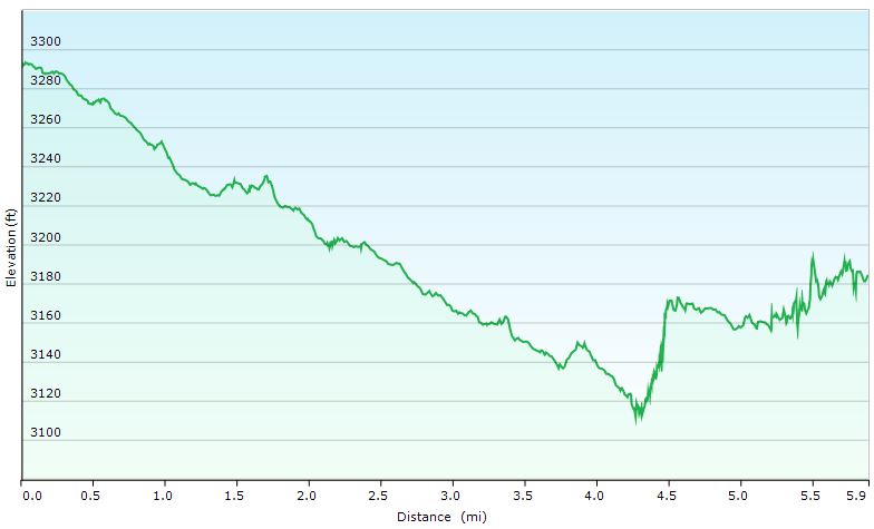
Day 2 Elevation Profile – Cranberry River Loop
Trails Used, Day 3
- Continue a short distance southwest on the fire road.
- At the sign for Kennison Mountain Trail, ford the Cranberry River (look for the blue diamond on the other side).
- Stock up on water here, as it will be your last reliable source for the rest of the day.
- Continue on the Kennison Mountain Trail.
- At the intersection with Frosty Gap Trail, head left (east) to stay on the Kennison Mountain Trail.
- Pass the intersection with South Fork Trail.
- Return to the parking lot.
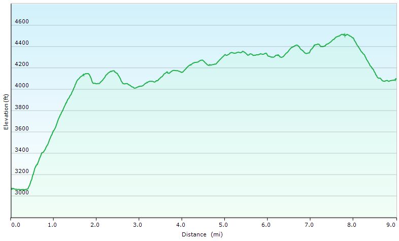
Day 3 Elevation Profile – Cranberry River Loop
Day 3 Mileage: 9 miles
Day 3 Gross Elevation Gain: 2,070 feet
Grand Total Mileage: 20 Miles
Grand Total Gross Elevation Gain: 2,494 feet
Notable Backpacking Gear
- Amok Draumr XL Hammock (flat laying hammock system)
- Amok Fjol XL Sleeping Pad
- Amok Borg Tarp
- EMS Longtrail 70 backpack
- Mesh water bottle pockets by JustinsUL
- Hammock Gear Burrow 40 Top Quilt
- DIY Esbit Stove
- Esbit Fuel Cubes
- Toaks 750ml Titanium Pot
- Sea to Summit Long Handled Spork
- Katadyn BeFree Water Filter
- Frogg Toggs Ultra-Lite Rain Jacket
- Outdoor Vitals Adventure Jacket, Loftek version
- Dutchware Folding Sit Pad
- Olight Wave LED Headlamp
- Garmin Oregon 650 GPS unit
- Casio ProTrek PRW-2500
- Mountain House Backpacking Meals


Disclosure: A commission may be earned on some of the links on this post.