
Join me for 3 days of Hammock Camping & Ultralight Backpacking on the Old Loggers Path in Pennsylvania’s Loyalsock State Forest.
For this 3 day, 2 night spring backpacking trip, I’ll be hiking a roughly 28 mile backpacking loop along babbling brooks, waterfalls, hardwoods and hemlocks. Being shoulder season in north central Pennsylvania, my weather ranged from highs in the 70’s down to just below freezing at night, with a little bit of rain sprinkled in for good measure.
Due to the weather, I packed some extra layers and a full set of rain gear. This increased my pack weight a bit, but I still managed to come in with a base weight of around 10.5 lbs or so. Water on the Old Loggers Path is fairly plentiful, so I got by with only carrying around 1 liter of water at a time.
Trail conditions on the OLP are a mix of nice flat dirt sections, punctuated by spurts of steep sections littered with Pennsylvania’s infamous rocks to keep you on your toes ; literally. Despite the occasional rough sections, the average daily gross elevation gain was only around 1,500 feet per day. I chose to do the loop in a counterclockwise direction, as this allowed me to camp in the Rock Run area after only about 7 miles after my mid-day start on day one.
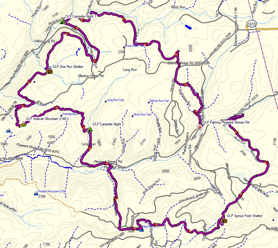
Old Loggers Path – Route Overview – Sintax77
No permit is required for dispersed camping in the Loyalsock State Forest, so long as you are only camping one night at each campsite. You can find more information on the Loyalsock State Forest website here.
Full GPS track data, including campsites, water sources, etc, for this trip and many others can be downloaded on my Trip Data Page.
You can also find lots of good info about the OLP here on the MidAtlanticHikes.com
Trailhead Used: Masten Camp Parking Lot , 41°30’25.2″N 76°49’15.6″W
Pleasant Stream Rd, Canton, PA 17724
The parking area on Pleasant Stream Rd has room for several vehicles and is easily accessible via 2wd. No parking fee or permit required.
Trails Used, Day 1
- Start counterclockwise on the orange blazed OLP trail
- Head back towards the intersection with the bridge. I turned left on Mt Pleasant Rd to do the loop counterclockwise. Crossing the bridge will take you on the OLP clockwise.
- Keep on following those orange blazes and stay aware of other old logging paths in the area that are not the OLP!
- Camp near the confluence of Yellow Dog Run and Rock Run
- There are multiple camping opportunities in this area for tents or hammocks with several pre-established fire ring and plenty of water.
Day 1 Mileage: 6.5 miles
Day 1 Gross Elevation Gain: 866 feet
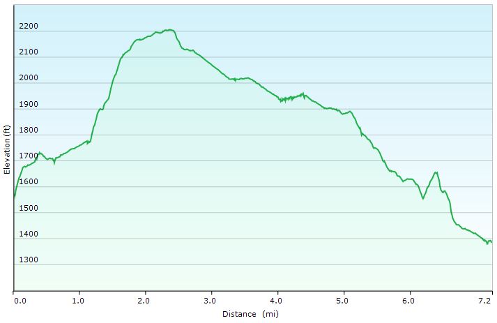
Old Loggers Path – Day 1 Elevation Profile – Sintax77
Trails Used, Day 2
- Continue on the Old Loggers Path
- Lunch Break at Doe Run Shelter
- Catch some views from Sullivan Mountain
- Camp along the Long Run
- This flat area after descending Sullivan mountain has plenty of flowing water and multiple sites with pre-established fire rings scattered about not too far from the trail.
- This flat area after descending Sullivan mountain has plenty of flowing water and multiple sites with pre-established fire rings scattered about not too far from the trail.
Day 2 Mileage: 10 miles
Day 2 Gross Elevation Gain: 1,516 feet
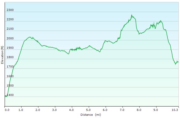
Old Loggers Path- Day 2 Elevation Profile – Sintax77
Trails Used, Day 3
- Continue on the Old Loggers Path.
- Cross Pleasant stream.
- This is the only water crossing that may pose a legitimate challenge after heavier rain falls. For me it wasn’t too bad, but it was still just below the knees with a decent current.
- Take a break at Sharp Top Vista.
- Take the spur trail to Sprout Point shelter for one last view.
- Double back to to the OLP.
- Return to Masten Camp parking lot.
Day 3 Mileage: 12 miles
Day 3 Gross Elevation Gain: 1,893 feet
Grand Total Mileage: 28.5 Miles
Grand Total Gross Elevation Gain: 4,275 feet
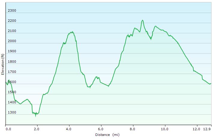
Old Loggers Path – Day 3 Elevation Profile – Sintax77
Notable Backpacking Gear
- Gregory Optic 48 Backpack, medium
- Dutchware Gear Half-Wit Hammock
- Simply Light Designs Trail Winder Underquilt / Underquilt Protector
- Hammock Gear Burrow 40 Top Quilt
- Hammock Gear Dyneema Hex Tarp
- DIY Cat Can Alcohol Stove
- Vargo Windscreen Pot Stand
- Toaks 750ml Titanium Pot
- Sea to Summit Long Handled Spork
- Katadyn BeFree Water Filter
- Outdoor Research Helium III Rain Jacket
- Outdoor Research Helium III Rain Pants
- Outdoor Vitals Satu Adventure Pants
- Outdoor Vitals Adventure Jacket, Loftek version
- Under Armor Charged Pursuit Running Shoes
- Wright Socks (I love these for blister prevention, particularly in wet conditions).
- Dutchware Folding Sit Pad
- Nitecore NU25 Headlamp
- Garmin Oregon 650 GPS unit
- Spot Gen3 GPS Messenger & SOS device
- Casio ProTrek FR-30 Smartwatch
- Packit Gourmet Backpacking Meals
- Oria Digital Thermometer with memory

FTC Disclosure: This post contains affiliate links, which means I may receive a commission for purchases made through some of my links.