
3 days of Hammock Camping in the Rain and Solo Ultralight Backpacking in the Linville Gorge Wilderness.
For this backpacking trip, I headed down to North Carolina’s Pisgah National Forest for some hammock camping along the Linville River. The particular section of river I chose was surrounded by the Linville Gorge, the upper ridges of which stand an average of 1,400 feet above the river banks below. This terrain, combined with a dense network of unofficial trails without signage or switchbacks, and often uncrossable river, can make for some rather challenging and exciting hiking. Add in a forecast of fog and hiking in the rain, and you’ve got yourself a recipe for some true southern outdoors adventure.
Despite the rain, my mid-June temp range for this trip was relatively warm at 70° – 48° or so. This allowed me to get my backpack’s base weight down to around 9 lbs by leaving my puffy jacket, base layers, warmer hat, gloves etc at home. I simply packed a long sleeve shirt and a buff and used my rain gear for supplemental warmth at camp.
I went with a fairly minimalist hammock camping setup for this trip. There are plenty of trees and fun unofficial campsite gems to be found in the Gorge that make ideal for hammocks. Water is obviously of minimal concern for the lower regions of the gorge. This allows you to save some weight on trails in those sections, but make sure to stock up when your route heads up towards the ridge. Especially if you’re looking to camp in one the beautiful ridge side campsites up there. The extra planning and water weight is well worth the views.
A free permit is required on weekends and holidays from May 1st through October 31st each year. You can find more information on the NFS Grandfather Ranger District website here.
If planning your own trip, I would highly recommend visiting LinvilleGorge.net for maps, info and extensive GPS data including official and unofficial trails, campsites, water sources, etc. Due to the nature of my trip and the fact that their data is so darn good, I didn’t package my own GPS file for this trip, but I did make an overlay map image from their track data that can be downloaded here. Just unzip it and copy the image file to your Garmin’s /Garmin folder if you’re using a Garmin GPS like me, or follow whatever instructions pertain to your particular GPS device.
Trailhead Used: Linville Falls Visitor Center , 35°57’16.9″N 81°55’40.2″W
Warrior Ln, Marion, NC 28752
This is an easily accessible paved parking lot with room for a ton of cars with bathrooms on site.
Trails Used, Day 1
- Plunge Basin Trail
- Yoricks Trail
- Gulf Contour Trail
- Gulf Ridge Trail
- Gulf Ridge Connector Trail
- Hill Trail
- Red North Trail
- Brushy Ridge Trail
- Spur trail to Reference Rock for a view of the gorge
- Red South Trail
- Devils Cliff Trail
- Jonas Ridge Trail
- Hawksbill Trail
- Setup camp on the summit of Hawksbill Mountain
- This is a dry campsite. I saw a few potential campsites with room for a couple tents or hammocks in each one, some more protected from the wind than others.
Day 1 Mileage: 11 miles
Day 1 Gross Elevation Gain: 3,613 feet
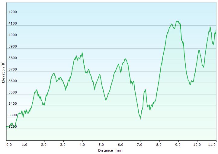
Day 1 Elevation Profile -Linville Gorge Backpacking Trip 2020 – Sintax77
Trails Used, Day 2
- Ledge Trail
- Backtrack to Red South Trail
- Camp near the intersection of Red South and Brushy Ridge Trail
Day 2 Mileage: 6.4 miles
Day 2 Gross Elevation Gain: 2,613 feet
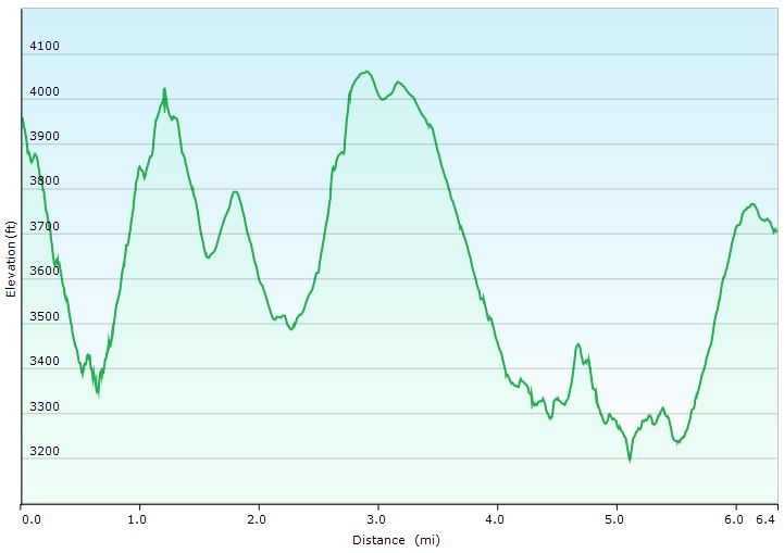
Day 2 Elevation Profile -Linville Gorge Backpacking Trip 2020 – Sintax77
Trails Used, Day 3
- Continue to backtrack towards Linville Falls
- Return to parking lot.
Day 3 Mileage: 5.1 miles
Day 3 Gross Elevation Gain: 1,109 feet
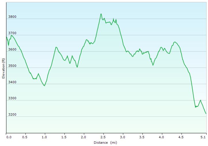
Day 3 Elevation Profile -Linville Gorge Backpacking Trip 2020 – Sintax77
Grand Total Mileage: 22.5 Miles
Grand Total Gross Elevation Gain: 7,335 feet
Notable Backpacking Gear
- Gregory Optic 48 Backpack, medium
- Dutchware Pack Cover
- Dutchware Gear Half-Wit Hammock
- Simply Light Designs Trail Winder Underquilt / Underquilt Protector
- Hammock Gear Burrow 40 Top Quilt
- Hammock Gear Dyneema Hex Tarp
- DIY Cat Can Alcohol Stove
- Vargo Windscreen Pot Stand
- Toaks 750ml Titanium Pot
- Sea to Summit Long Handled Spork
- Katadyn BeFree Water Filter
- Outdoor Research Helium III Rain Jacket
- Outdoor Research Helium III Rain Pants
- Outdoor Vitals Satu Adventure Pants
- Outdoor Vitals Adventure Jacket, Loftek version
- Buff head wrap
- Adidas Terrex Swift R2 GTX Hiking Shoes
- Wright Socks (I love these for blister prevention, particularly in wet conditions).
- Dutchware Folding Sit Pad
- Nitecore NU25 Headlamp
- Garmin Oregon 650 GPS unit
- Spot Gen3 GPS Messenger & SOS device
- Casio ProTrek FR-30 Smartwatch
- Peak 2 Backpacking Meals (my fave was the Chicken Alredo)
- Mountain House Granola Breakfast
- Korean Coffee Sticks
- Oria Digital Thermometer with memory

FTC Disclosure: This post contains affiliate links, which means I may receive a commission for purchases made through some of my links.