
3 Days of Backpacking, Hiking & Hammock Camping on the Appalachian Trail in Virginia.
For this late summer backpacking trip I’ll be hiking the Virginia Triple Crown, which consists of three iconic Virginia hiking destinations – McAfee Knob, Tinker Cliffs, and Dragon’s Tooth.
To create the loop, I essentially took an Appalachian Trail section hike and combined it with the North Mountain trail to close it off into a 35 mile backpacking loop. This gave me a healthy southern mix of mountain hiking, open pastures, and sweeping summit views.
I went with my most basic warm weather ultralight backpacking gear list for this trip, just to keep things simple and light. Due to the threat of rain, I also included a full set of rain gear. Surprisingly how I was still able to keep my base weight down to around 7.5 lbs. This was mostly achieved by simply leaving non critical items at home. Notable items are below or you can see my full gear list with weights & gear links on LighterPack here.
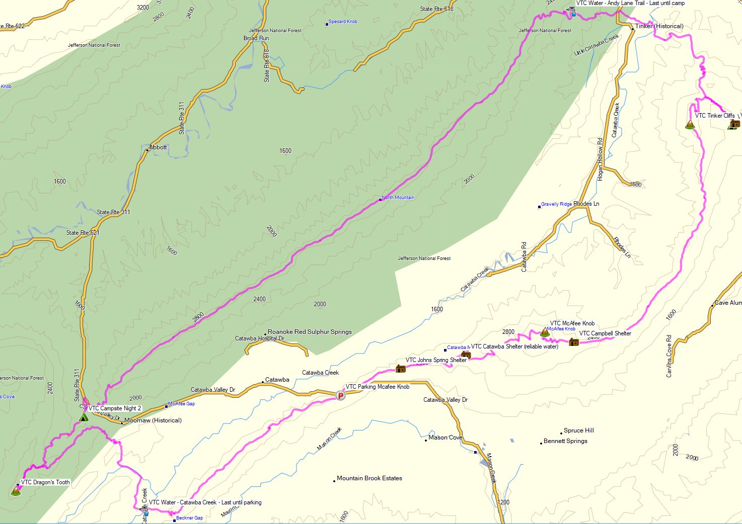
Virginia Triple Crown Route Overview – Sintax77
No permit is required to camp in this area, but there are some camping restrictions along the Appalachian Trail portion of the hike as well as some private land traversals. You can find more information on the Roanoke Appalachian Trail Club site here.
While on the AT in this area, you may only camp at one of the four designated shelters. Since I was exclusively on the AT for the entire first day, this gave me the following camping options:
- Jonh’s Spring Shelter
- Catawba Shelter (reliable water)
- Campbell Shelter
- Lambert’s Meadow Shelter (reliable water)
I chose to camp near Lambert’s Meadow Shelter, as it was the farthest one into the loop and offered reliable water.
Full GPS track data, including campsites, water sources, etc, for this trip and many others can be downloaded on my Trip Data Page.
Trailhead Used: McAfee Knob Trailhead Parking, 37°22’48.4″N 80°05’22.8″W
Catawba Valley Dr, Catawba, VA 24070
This is an easily accessible paved lot with room for many cars, however, it can be a real zoo on peak season weekends. This is one of the reasons that I saved doing this trip for mid-week in September.
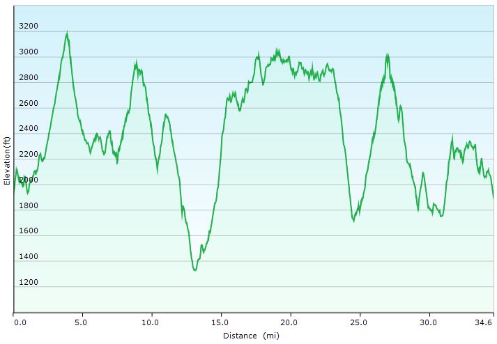
Virginia Triple Crown Loop – Full Elevation Profile – Sintax77
Trails Used, Day 1
- Appalachian Trail North
- After 4 Miles arrive at McAfee Knob
- Continue on AT north
- Walk along Tinker Cliffs for more amazing views
- Stay on the AT north
- Setup Camp near Lambert’s Meadow Shelter
- There is a shelter and multiple camping options here. I camped by the brook just below the shelter, but there is more camping about a quarter mile further down the Appalachian Trail. I managed to get decent water right where I camped by the shelter, but I’ve read that it can be unreliable during drier periods. If that’s the case, the previously mentioned alternate campsites are said to have more reliable water.
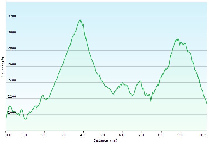
Day 1 Elevation Profile – Virginia Triple Crown – Sintax77
Day 1 Mileage: 10.3 miles
Day 1 Gross Elevation Gain: 3,197 feet
Trails Used, Day 2
- Backtrack a half mile on the Appalachian Trail the same way you came in.
- Leave the AT for the Andy Layne Trail
- North Mountain Trail
- This trail is on a ridge without water for 10 miles. Make sure to stock up on water below before leaving the Andy Layne trail.
- Dragon’s Tooth Trail (on the other side of Catawba Valley Dr)
- Camp near the Dragon’s Tooth Trail
- There is a confluence of streams and ample camping opportunities about a quarter mile in from the Dragon’s Tooth parking lot. Some spots are more obvious than others so don’t be afraid to poke around if spots are already taken when you get there. There is a general store with provisions and hot food less than a quarter mile west from the parking lot on Catawba Valley Drive.
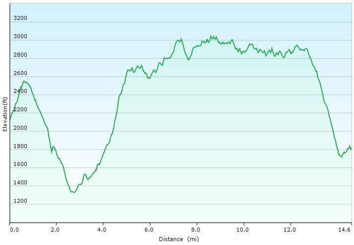
Day 2 Elevation Profile – Virginia Triple Crown – Sintax77
Day 2 Mileage: 14.6 miles
Day 2 Gross Elevation Gain: 3,911 feet
Trails Used, Day 3
- Continue on the Dragon’s Tooth Trail.
- Soak in the views at Dragon’s Tooth, an interesting rock formation with sweeping views of the valley below.
- Backtrack 1 mile to the last intersection.
- Appalachian Trail North
- Stock up on water just after crossing Blacksburg Rd (the next 4 miles will be dry)
- Continue on the AT north.
- Return to the McAfee Knob trailhead parking area.
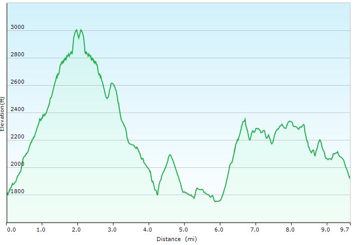
Day 3 Elevation Profile – Virginia Triple Crown – Sintax77
Day 3 Mileage: 9.7 miles
Day 3 Gross Elevation Gain: 3,241 feet
Grand Total Mileage: 34.6 Miles
Grand Total Gross Elevation Gain: 10,349 feet
Notable Backpacking Gear
- ULA Ohm 2.0 Backpack
- Dutchware Pack Cover
- Dutchware Gear Half-Wit Hammock
- Dutchware Whoopie Hook hammock suspension w/ kevlar tree straps.
- Hammock Gear Burrow 40 Top Quilt
- Hammock Gear Phoenix 40 Underquilt
- Dutchware Folding Sit Pad
- Hammock Gear Dyneema Hex Tarp
- DIY Cat Can Alcohol Stove
- Light My Fire Mini Fire Steel Striker
- Vargo Windscreen Pot Stand
- Toaks 750ml Titanium Pot
- Sea to Summit Long Handled Spork
- Potable Aqua Water Purification Tablets
- Outdoor Research Helium III Rain Jacket
- Outdoor Research Helium III Rain Pants
- Outdoor Vitals Satu Adventure Pants
- La Sportiva Wildcat Trail Running Shoes
- Nitecore NU25 Headlamp
- Casio ProTrek FR-30 Smartwatch
- Knorr Sides
- Korean Coffee Sticks

Camera and Nav Gear used for this episode
- GoPro Hero 8 Black
- GoPro Shorty Tripod Grip
- 128GB Sandisk Extreme Memory Card
- Spot Gen3 GPS Messenger & SOS device
FTC Disclosure: This post contains affiliate links, which means I may receive a commission for purchases made through some of my links.