
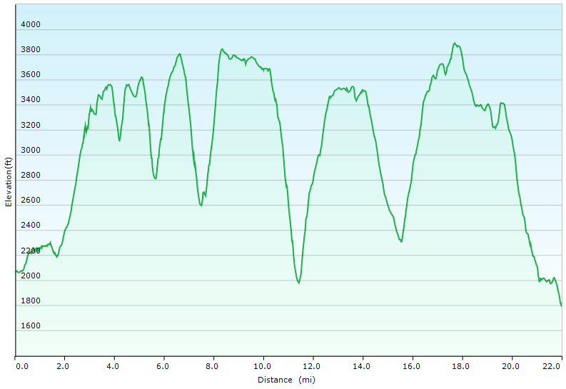
Some say it’s the Toughest, most Dangerous Hiking Trail in the east. We set out on a backpacking trip to find out how tough the Devil’s Path trail really is.
Set in New York’s Catskill Mountains, the Devil’s Path is a 24.6 mile long end to end hike on steep, rocky terrain with around 8,500 feet of elevation gain and and 9,000 feet of elevation loss.
The mountain range that the Devil’s Path traverses is basically one large plateau with a handful of deep notches carved into it. The result? Almost all of the elevation change is crammed into a handful of 1 mile or less stretches, with little to no distance in between each ascent and descent. Scrambles, loose rock and mazes of gnarly roots add to the challenge.
Myself, Kyle from the Trail Tails Podcast and Flossy packed up our backpacks with some tents and hammocks and hit the trail on a mid-August morning to find out if this hiking trail would live up to it’s devilish reputation.
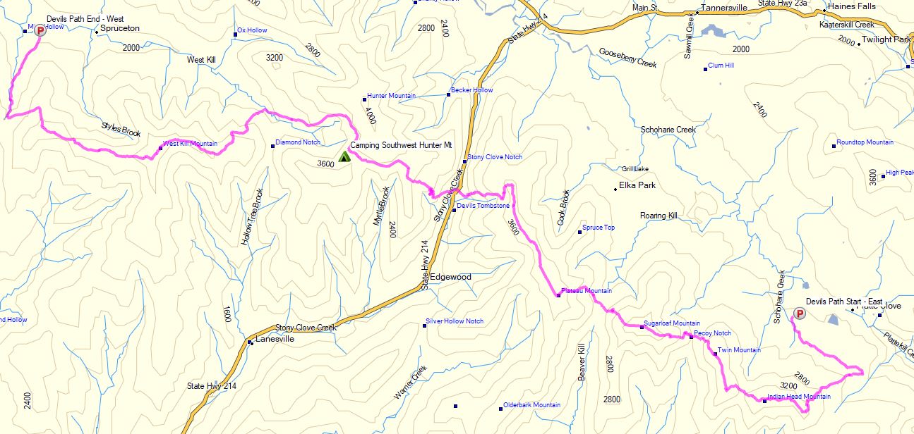
Catskills Devil’s Path Route Overview – Sintax77
There are 5 Major Summits (Catskill 35ers) on this hike
- Indian Head Mountain 3,573′
- Twin Mountain 3,652′
- Sugar Loaf Mountain 3,806′
- Plateau Mountain 3,840′
- West Kill Mountain 3,880′
Starting Trailhead Used (East): Platcove Trailhead , 42°08’02.5″N 74°06’16.1″W
Prediger Trail Road, Elka Park, NY 12427
This is an easily accessible parking lot with room for a decent amount of cars, but it does reportedly fill up by early morning on weekends.
Full GPS track data, including campsites, water sources, etc, for this trip and many others can be downloaded on my Trip Data Page.
Trails Used, Day 1
- From the Parking lot, follow the red plastic trail markers for the Devils Path.
- At the Mink Hollow intersection (mile 8) take the spring side trail for water.
- Continue on the DP trail
- Grab water at Devil’s Acre Lean-to (it’s a couple hundred feet beyond the shelter)
- Continue on the DP for 1/4 mile
- To the left of the DP there will be a herd path to Southwest Hunter Mountain (Leavitt Peak)
- After a tenth of a mile you’ll find some nice campsites on the right side of the herd path. Note: The left side of the herd path is just above 3500′ and not legal to camp on.
Day 1 Mileage: 14.5 miles
Day 1 Gross Elevation Gain: 6,694 feet
Day 2 Gross Descent: 5,205 feet
Trails Used, Day 2
- Head back out on the SW Hunter herd path
- Continue west on the Devil’s Path trail.
- Keep following those red discs until you arrive at the Devil’s Path Western Trailhead on Spruceton Rd.
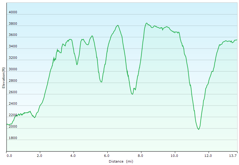
Day 2 – Devil’s Path Elevation Profile – Sintax77
Day 2 Mileage: 10.1 miles
Day 2 Gross Elevation Gain: 2,210 feet
Day 2 Gross Descent: 3,968 feet
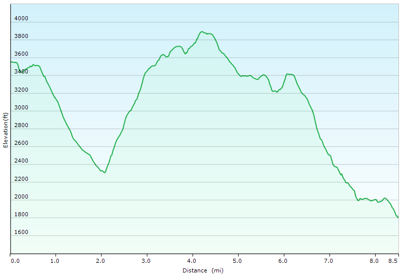
Devil’s Path Full Elevation Profile – Sintax77
Grand Total Mileage: 24.6 Miles
Grand Total Gross Elevation Gain: 8,904 feet
Grand Total Gross Descent: 9,173 feet
Ending Trailhead Used (West): Spruceton Road Trailhead ,
42°11’30.8″N 74°19’30.0″W
1589 County Rd 6, West Kill, NY 12492
Check out Kyle’s YouTube Channel
LighterPack link for my gear breakdown for this trip – 7.4 lbs Base weight
Notable Backpacking Gear
- ULA Ohm 2.0 Backpack
- Dutchware Pack Cover
- Dutchware Gear Half-Wit Hammock
- Dutchware Whoopie Hook hammock suspension w/ kevlar tree straps.
- Hammock Gear Burrow 40 Top Quilt
- Hammock Gear Phoenix 40 Underquilt
- Dutchware Folding Sit Pad
- Hammock Gear Dyneema Hex Tarp
- DIY Cat Can Alcohol Stove
- Light My Fire Mini Fire Steel Striker
- Vargo Windscreen Pot Stand
- Toaks 750ml Titanium Pot
- Sea to Summit Long Handled Spork
- Potable Aqua Water Purification Tablets
- Outdoor Research Helium III Rain Jacket
- Outdoor Research Helium III Rain Pants
- Outdoor Vitals Satu Adventure Pants
- La Sportiva Wildcat Trail Running Shoes
- Nitecore NU25 Headlamp
- Casio ProTrek FR-30 Smartwatch
- Mountain House Southwest Breakfast Hash
- Korean Coffee Sticks

Camera and Nav Gear used for this episode
- GoPro Hero 8 Black
- GoPro Shorty Tripod Grip
- 128GB Sandisk Extreme Memory Card
- Garmin Oregon 650 GPS unit
- Spot Gen3 GPS Messenger & SOS device
FTC Disclosure: This post contains affiliate links, which means I may receive a commission for purchases made through some of my links.