Hammock Camping on the Six Husbands Trail

Hammock Camping and Solo Backpacking in the White Mountains of New Hampshire

FTC Disclosure: This post contains affiliate links, which means I may receive a commission for purchases made through some of my links.

For this adventure, I decided to get back to my ultralight backpacking roots with a rugged 27 mile loop through the Great Gulf Wilderness, Dry River Wilderness, and Presidential Range, with a gross elevation gain of around 8,400 feet. The centerpiece of my loop would be the Six Husbands Trail, a trail that some say is the most difficult in the White Mountain National Forest. Now , if you’re familiar with the WMNF, you probably know that just about every trail is pretty intense, so this could get interesting…

For sleep and shelter, I went with my standard minimalist hammock camping setup consisting of a 10 oz hammock, 5 oz tarp, and a pair of 40° down quilts.  This got my base weight down to around 7 lbs. A full gear list can be found at the bottom of this post.

The Six Husbands Trail was Built from 1909 to 1910 by trail builder Warren W. Hart of the Appalachian Mountain club. Hart was known to build his trails specifically with adventure in mind, and this trail was no exception. It begins deep in the Great Gulf Wilderness at the junction with Wamsutta Trail, which along with the connected Alpine Garden trail is actually just the renamed southern portion of the Six Husbands trail. Wamsutta was one the six husbands of female Indian Chief, Weetamoo, who has a nearby waterfall named after her.

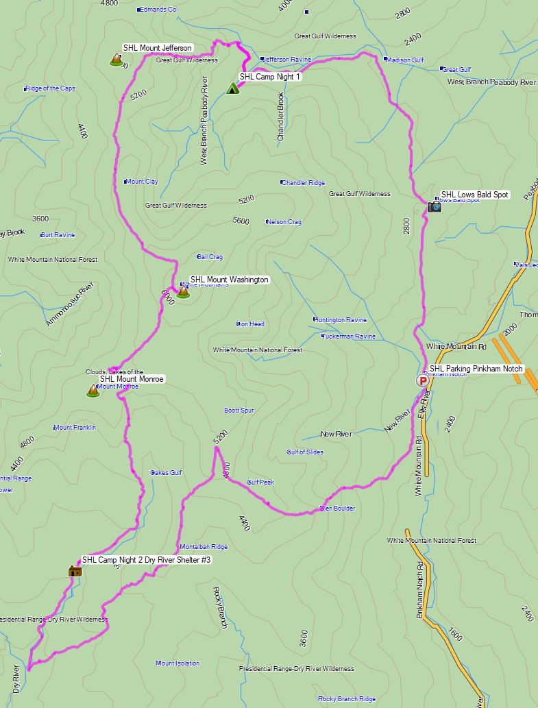
White Mountains Six Husbands Backpacking Loop – Route Overview – Sintax77

Continue reading

Backpacking the Devils Path – Most Dangerous Hiking Trail?

Some say it’s the Toughest, most Dangerous Hiking Trail in the east. We set out on a backpacking trip to find out how tough the Devil’s Path trail really is.


Set in New York’s Catskill Mountains, the Devil’s Path is a 24.6 mile long end to end hike on steep, rocky terrain with around 8,500 feet of elevation gain and and 9,000 feet of elevation loss.

The mountain range that the Devil’s Path traverses is basically one large plateau with a handful of deep notches carved into it. The result? Almost all of the elevation change is crammed into a handful of 1 mile or less stretches, with little to no distance in between each ascent and descent.  Scrambles, loose rock and mazes of gnarly roots add to the challenge.

Myself, Kyle from the Trail Tails Podcast and Flossy packed up our backpacks with some tents and hammocks and hit the trail on a mid-August morning to find out if this hiking trail would live up to it’s devilish reputation.

Catskills Devil’s Path Route Overview – Sintax77

There are 5 Major Summits (Catskill 35ers) on this hike

  • Indian Head Mountain 3,573′
  • Twin Mountain 3,652′
  • Sugar Loaf Mountain 3,806′
  • Plateau Mountain 3,840′
  • West Kill Mountain 3,880′

Starting Trailhead Used (East): Platcove Trailhead , 42°08’02.5″N 74°06’16.1″W
Prediger Trail Road, Elka Park, NY 12427

This is an easily accessible parking lot with room for a decent amount of cars, but it does reportedly fill up by early morning on weekends.

Continue reading