Join TJ & I for 3 days of hiking, camping & backpacking in New Hampshire’s Great Gulf Wilderness. Oh, & I also fall on my face.
For this adventure, we’ll be revisiting an attempt at a hike that I originally did as a solo backpacking trip a few years back. A rather aggressive loop, chalking up 30+ miles and over 15,000 feet gross elevation gain, the plan was to give it another go while giving TJ an ultimate sampler platter of the White Mountains. As fate would have it, things would corkscrew towards another outcome…
Full GPS track data and waypoints for various POI’s on this trip are available for download on the Trip Data Page.
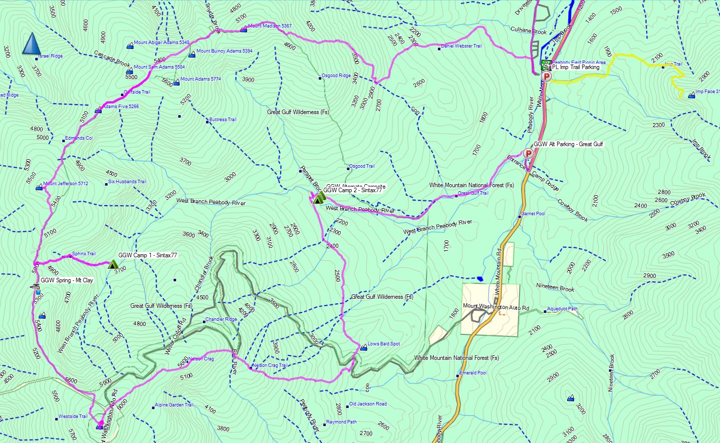
Trails Used, Day 1 (in order)
Road hike north on Rt 16 to Dolly Copp Campground
Daniel Webster Scout Trail
Appalachian Trail South
Sphinx Trail
Camp along Sphinx Trail, just before junction with Great Gulf Trail
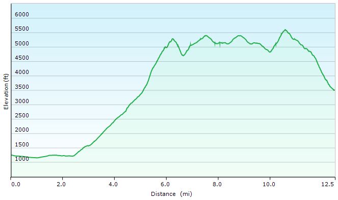
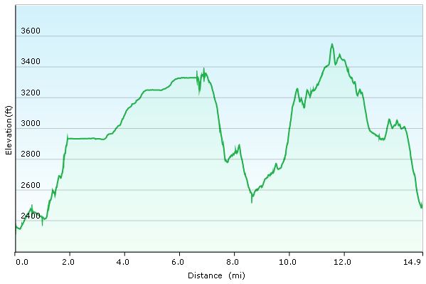
Great Gulf Loop Day 1 Elevation Profile – Sintax77
Day 1 Mileage: 12.5 miles Day 1 Gross Elevation Gain: 6,661′
Trails Used, Day 2 (in order)
Double back on Sphinx Trail
Appalachian Trail South
Trinity Heights Connector to Summit of Mt Washington
Have a Chili Dog at the Summit
Nelson Crag Trail
Appalachian Trail South
Great Gulf Trail
Camp near Gulf Trail along ridge
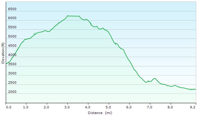
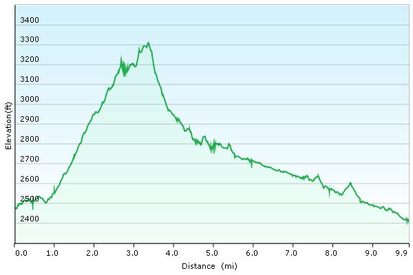
Great Gulf Loop Day 2 Elevation Profile – Sintax77
Day 2 Mileage: 9.2 miles Day 2 Gross Elevation Gain: 3,658′
Trails Used, Day 3 (in order)
Great Gulf Trail
Short road hike back to car parked at Imp Trail Head
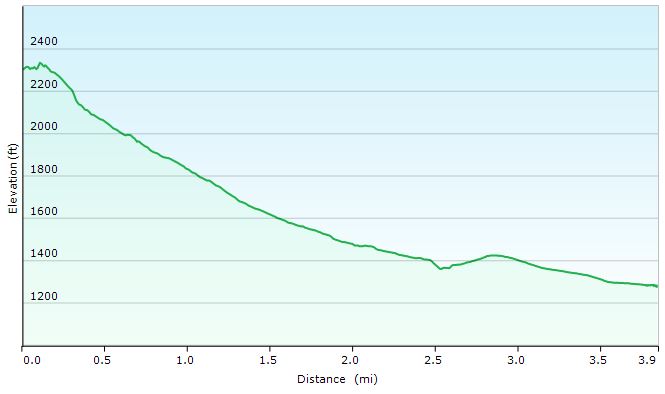
Great Gulf Loop Day 3 Elevation Profile – Sintax77
Day 3 Mileage: 3.9 Day 3 Gross Elevation Gain: 108′
Mileage Grand Total for Trip: 25.6 Gross Elevation Gain Grand Total for Trip: 10,319′
Join Mike & I on Colorado’s Four Pass Loop for 3 days of hiking, backpacking & hammock camping.
For this multi-part adventure, we’ll be faced with two challenges.
Phase 1 (seen in the prior Pt 1 video): Driving on a substantial time crunch from the east coast to Colorado, without any hotels or road food purchases. This will not only keep the budget low, but will also save us a ton of time by not having to check-in/out, be tempted to sleep in, decide where/what to eat, stand in lines etc. Sleeping will be done in the car (while the other person drives) and all meals will be comprised of cooler-stored left-overs and pre-purchased beverages. The only stops allowed: bathroom breaks and gas pumps.
Phase 2 (covered in this video, Pt 2) will be a multi-day hike of the Four Pass Loop, within the Maroon Bells Snowmass Wilderness, located just outside of Aspen Colorado (about 3 hours west of Denver). We chose to do the loop in a counter-clockwise direction.
It’s 4:30 PM on a weekday. Can Mike and I make it from Philly to Aspen, Colorado by tomorrow night for a hike the next morning? Hop in and join us for the drive.
For this multi-part adventure, we’ll be faced with two challenges.
Phase 1 (seen in this video, Pt 1): Driving on a substantial time crunch from the east coast to Colorado, without any hotels or road food purchases. This will not only keep the budget low, but will also save us a ton of time by not having to check-in/out, be tempted to sleep in, decide where/what to eat, stand in lines etc. Sleeping will be done in the car (while the other person drives) and all meals will be comprised of cooler-stored left-overs and pre-purchased beverages. The only stops allowed: bathroom breaks and gas pumps.
Phase 2 (covered in the next video, Pt 2) will be a multi-day hike of the Four Pass Loop, within the Maroon Bells Snowmass Wilderness, located just outside of Aspen Colorado (about 3 hours west of Denver).
Departure time:4:30 PM, after work on 8/30/16.
Total Distance:1,900 miles (one way)
Time allowance: (yes, without speeding): 32 hours, which would get us to the trail head before midnight the next day.
States traversed: Pennsylvania, Ohio, Indiana, Illinois, Iowa, Nebraska, Colorado
Join Sara, our dog Denali, & I for some Catskills hiking, trail cooking, backpacking, and hammock camping in upstate New York.
For this backpacking trip, we’ll be hiking and camping near Slide Mountain and the East Branch Neversink River in the Catskills, complete with a visit to the summit of Table Mountain and Peekamoose Moose Mountain. The mileage will be low, but the star of this trip isn’t the trails. It’s the food. Good old, classic trail cooking.
What’s on our backpacker’s menu? Well, Sara had a craving for some trail pizza in the middle of the woods somewhere, and I was up for the challenge. Were we successful? You’ll just have to come along and find out. Either way, it’s bound to be an adventure. 😉
Full GPS data for this, as well as all of my other trips, is available on the Trip Data page.
Pheonicia East Branch Trail Peekamoose Table Trail
Set up camp after second bridge (the double log one) at N41° 58.474′ W74° 25.734′
Continue up Peekamoose Table Trail towards summit of
Table Mt and Peekamoose Mountain
Lunch / Snack at summit and Return to camp on the East Branch Neversink River
Day 1 Mileage: 7.8 miles, including summit round trip (about 3 miles each way) Day 1 Gross Elevation Gain: 2,130′
Trails Used Day 2, in Order
Peekamoose Table Trail Pheonicia East Branch Trail Return to vehicle at Denning Rd Trailhead
Day 2 Mileage: 1.8 miles Day 2 Gross Elevation Gain:146′
Trip Total Mileage: 9.6 miles Trip Total Elevation Gain: 2,276
Trail Pizza Ingredients
Boboli Pizza Crust, Individual Size – 2 Pack
Boboli Pizza Sauce Individual Pack (comes in 3 pack box)
Cabot Mozzarella Cheese, Shredded – 8 oz package (2 cups volume)
Hormel Pepperoni, pre-sliced – 6 oz package (enough for 2 pizzas, plus snacking) Camp Cooking Gear Used for Pizza
A discussion on clothing choices for backpacking, hiking & camping trips.
In this video, I’ll go over each backpacking clothing item that I’ll be wearing for an upcoming backpacking trip, as well as spare and alternate clothing options that I’ll be packing for the hike.
These are pretty much the same clothes take I would take on just about any 3-season hiking trip.
Join Sara & I for 3 days of desert hiking, backpacking & camping in the Superstition Mountains. And who knows – maybe Sara will find the Lost Dutchman’s Gold Mine…
For this desert backpacking trip, we’ll be hiking a loop in the Superstition Wilderness, within the greater Tonto National Forest – about 60 miles east of Phoenix, Arizona. Not only was this a beautiful and scenic hike due to the stark desert surroundings and sharp, rugged peaks, but this particular region has added bonus – a rich history full of intrigue and lore right at home in your favorite spaghetti western flick. Some of these tales are indisputable facts. Others, are more debatable – the stuff of legends and mystery. The most notable and famous of those stories being that of Jacob Waltz, or as it’s commonly referred to, the mystery of the Lost Dutchman’s Gold.
As touched on in the video, the story of the Dutchman and the lost gold mine is much to deep to give justice to in the passing of a hiking video, so for those interested, I highly recommend taking the time to check out the various iterations of the story, theories, etc. For the sake of this post though, the basic idea goes like this – Jacob Waltz stumbled upon some gold in the Superstition Mountains. Whether it was an actual mine, or a hidden cache that was originally mined elsewhere, depends on which version of several accounts you choose to believe. In fact, even the fact that he came upon it accidentally is up for debate as well. Some iterations of the tale suggest that he was given the details of the hidden mine after saving the life of a man who belonged to a wealthy Mexican mining family. The name of that family, by the way, was Peralta – you know, like the trailhead we parked at. But anyway, I’m getting ahead of myself and going down the rabbit hole. Hmm, maybe the gold was hidden in a burrow of sorts, and not an actual gold mine. No wait, I’ve got to stop this.
Okay, let me try this again. Somehow, Jacob knew where a bunch of gold was in these mountains, and he kept it a complete secret, despite rumors throughout the years that he knew about it’s location. People would try to follow him when he went into the mountains, but he always lost them, or at the least, waved a gun at them until they left. Finally, on his death bed in 1891, he confirmed the gold mine and gave some info on it’s whereabouts to two individuals. Apparently, it wasn’t quite enough info, because they never found it after years of searching. Word spread, many more people started searching, and they continue to search until this day. People have gone missing while searching, some have even had their skull found right on one of the trails we hiked on our loop, complete with two bullet holes and their body found separately 3/4 of a mile away (his name was Adolf Ruth, and he went into the Superstitions in search of the gold back in 1931) .
So what does all this have to do with our backpacking trip? Did we find some gold or something? Am I devoting my life to finding the Lost Dutchman’s Mine? Well no, but it makes hiking around out there pretty cool and Old Westy, if you ask me. At the very least, it gives you something to ponder as you hike along the cactus covered traverses, baked incessantly by a sun they just may have glinted off of Jacob Waltz’s prize back in the 1800’s.
But anyway, back to the hike we did. Here’s the details…
Route Overview – Hiking the Superstition Mountains – Sintax77
Season / Time of Year
Winter – January 20th to January 23, 2016.
Elevation Range
Minimum – 2,283′
Maximum – 3,550′
Full GPS track data and waypoints are available on the Trip Data page.
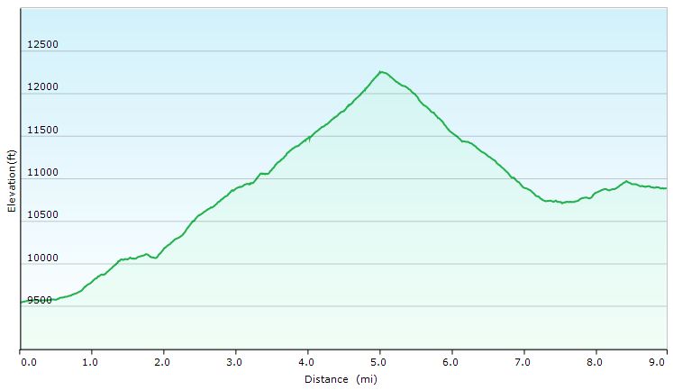
Trails Used Day 1 (in order of use) Peralta Trailhead Parking Lot, Dutchman Trail Set up camp in a relatively flat area along the trail, about .75 miles after crossing an intermittent stream. This particular stream actually had a decent flow at the time, but depending on recent conditions and time of year, it may not always be that way.
Day 1 Total Mileage: 2 miles Day 1 Total Elevation Gain: 344′
Day 1 Elevation Profile – Superstition Mountains Hike
Trails Used Day 2 (in order of use)
Continue on Dutchman Trail
Pass the intersection with Coffee Flat Trail to stay on Dutchman Trail, after which you’ll begin to rack up the bulk of your elevation gain for the day.
Leave the Dutchman Trail and head east on the Whiskey Springs Trail. Just before the upcoming trail intersection, the trail crosses LeBarge Creek (where we stocked up on water for the rest of the day)
At the intersection, turn left to head west on the Red Tanks Trail.
Red Tanks Trail ends at the intersection with Dutchman Trail.
Turn right to head north on Dutchman Trail.
Set up camp along Dutchman Trail.
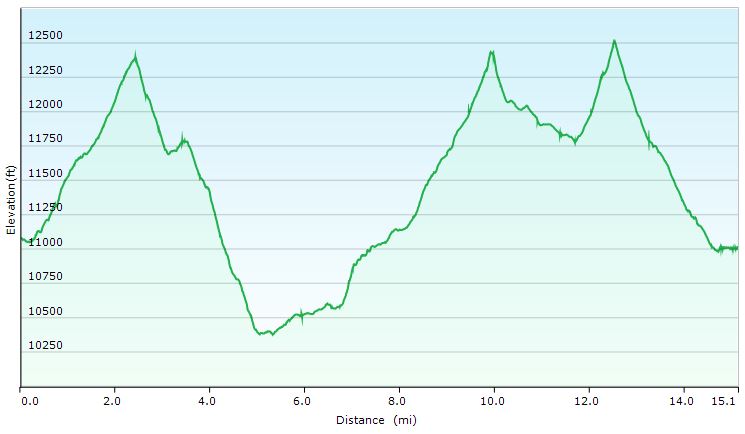
Day 2 Total Mileage:10 miles Day 2 Total Elevation Gain:1,325′
Day 2 Elevation Profile – Superstition Mountains – Sintax77
Trails Used Day 3 (in order of use)
Continue on Dutchman Trail
At the intersection, continue straight (west) on Bull Pass Trail
Turn left to head south on Black Top Mesa Trail, towards the top of Black Top Mesa
Explore the mesa and hunt for the Spanish Hieroglyphs or maybe some of the Lost Dutchman’s Gold, etc.
Retrace your steps back down Black Top Mesa Trail.
At the bottom, turn right to head east on the unofficial Bull Pass Alternate Trail (not the same as the previous Bull Pass Trail).
At the intersection, turn right to head south on our recurring friend, Dutchman Trail.
At the intersection, depart the Dutchman Trail and take Terrapin Trail.
At the intersection, turn right to head south on Bluff Springs Trail.
Return to the Peralta Trailhead parking lot.
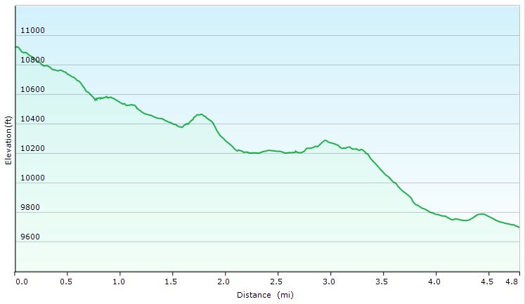
Day 3 Total Mileage: 15 miles (plus a couple miles of meandering about on Blacktop Mesa) Day 3 Total Elevation Gain:2,933 feet
Day 1 Elevation Profile – Superstition Mountains – Sintax77
Trip Grand Total Mileage: 27 Miles Trip Grand Total Elevation Gain: 4,662′
Highly recommended book for hikes in this area:
‘Hiker’s Guide to the Superstition Wilderness‘ by Jack Carlson and Elizabeth Stewart
This book appears to be out of print, but I managed to get a used copy and love it. It has detailed descriptions of all the trails, with some cool related history mixed in. It also contains plenty of solid maps and a bunch of suggested hikes.

 and
and .
. (from dollar store, or whatever)
 – rack used to hold pizza
 (used as a plate / prepping dish / cutting board)
 (zip-off shorts)
 (quarter length)
 shoes
shoes shoes
shoes


 (synthetic or merino wool)


 . For the sake of this post though, the basic idea goes like this – Jacob Waltz stumbled upon some gold in the Superstition Mountains. Whether it was an actual mine, or a hidden cache that was originally mined elsewhere, depends on which version of several accounts you choose to believe. In fact, even the fact that he came upon it accidentally is up for debate as well. Some iterations of the tale suggest that he was given the details of the hidden mine after saving the life of a man who belonged to a wealthy Mexican mining family. The name of that family, by the way, was Peralta – you know, like the trailhead we parked at. But anyway, I’m getting ahead of myself and going down the rabbit hole. Hmm, maybe the gold was hidden in a burrow of sorts, and not an actual gold mine. No wait, I’ve got to stop this.
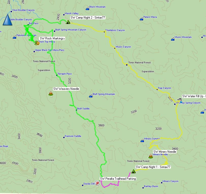


 (long version)
 for water storage.
 for eating our chili and queso appetizer
 on top of a


 water filter configured in a gravity setup
 ‘ by Jack Carlson and Elizabeth Stewart