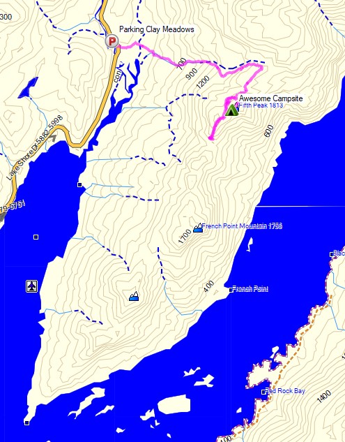
Camping and Backpacking in the Adirondacks on the Tongue Mountain Range.
For this overnight backpacking trip, Sara, Denali and I headed up to New York for some laid back camping on the summit of Fifth Peak Mountain, overlooking Lake George. The Tongue Mountain Range is a 3 mile long peninsula, so named because it looks like a tongue jutting out into the 32 mile long Lake George. Our plan was to hike in a few miles to the top of the range and hit the first peak at the top of the peninsula to set up for an afternoon and night of relaxed camping. The next morning we would have the option to either continue along the 13 mile long Tongue Mountain loop, or hike back out the same way we came in.
We had our dog with us, so we decided to return to tent camping for this trip. We did finally upgrade our previous budget tent to a four person (or 2 plus a dog) Marmot Limelight 4p tent though. And as I usually do for trips with my wife and dog, I packed in a massive backpack full of comfort camping gear and fun camp food. A more detailed gear list can be found at the bottom of this post.
Thank you to Anker for sponsoring this video. My viewers can get $100 off the Anker Powerhouse II 800 by using this link on Amazon or direct from Anker.
There is no permit required for backcountry camping on the Tongue Mountain Range, but there are certain rules and regulations. You get find more info on the official NY DEC website here.
Join Sara and I for 3 Days of Camp Cooking, Hiking, & Backpacking in the Dolly Sods Wilderness.
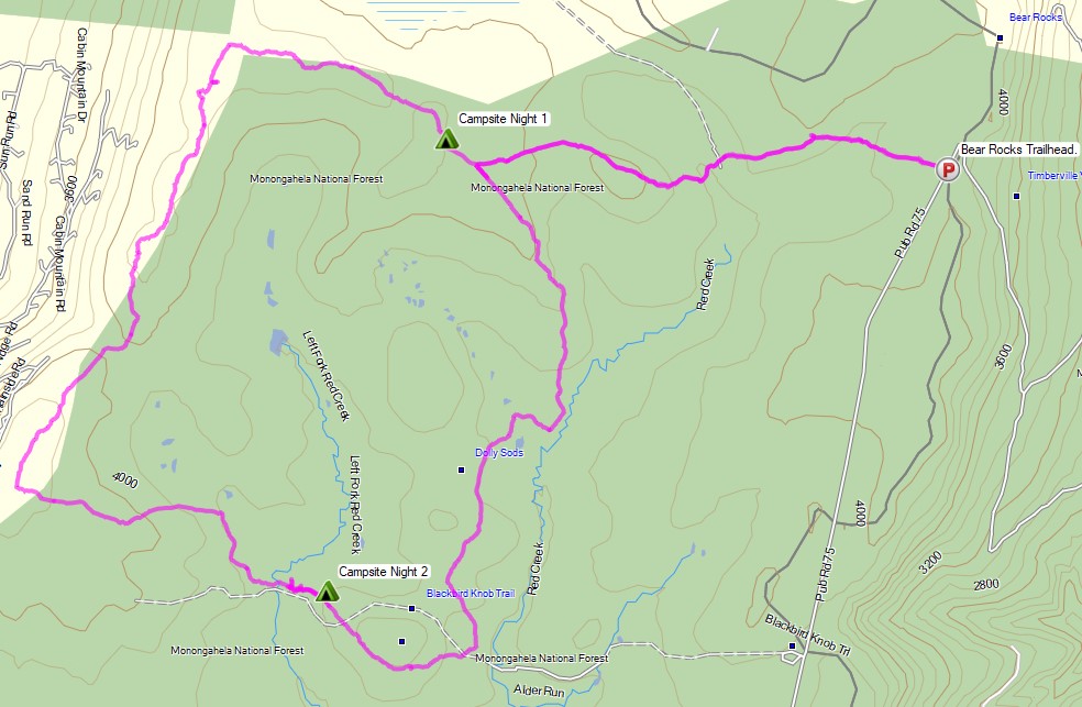
For this 3 day, 2 night backpacking trip, Sara, Denali and I decided to do some fall foliage camping in West Virginia’s Dolly Sods Wilderness, part of the larger Monongahela National Forest. Dolly Sods is located in the Allegheny Mountains on the highest plateau east of the Mississippi river and features some of the most varied and scenic terrain available to hikers in the Mid-Atlantic region.
We had our dog with us on this trip, so we decided to give tent camping a go this time around to keep us all together in one spot. I also decided to totally throw lightweight backpacking out the window for this trip, so I brought along my Fjallraven Kajka 75 backpack and stuffed it to the gills with various backpacking gear, just to have a little fun and switch things up a bit (gear list at end of post). This decision was made easier by the fact that we were starting at Bear Rocks trailhead, which is already high up on the plateau with minimal elevation changes.
Campsites and great views are fairly abundant in Dolly Sods, so our general plan was to keep the mileage low and focus on a relaxed hiking pace, fun backpacking food and camp cooking. It was the perfect recipe for a laid back camping trip. Other than the whole leaking sleeping pad situation to make things more interesting…
Route Overview – Dolly Sods Fall Backpacking Loop – Sintax77
No permit is required to camp in the Dolly Sods Wilderness, but there are rules and regulations regarding backcountry camping. You can find more information on the USFS Dolly Sods website here.
No permit is required to camp in the George Washington National forest, but there are rules and regulations regarding backcountry camping. You can find more information on the George Washington & Jefferson National Forest website here.
Join Sara and I for 3 days of Hiking & Hammock Camping on a Backpacking Trip in the Adirondack’s Dix Mountain Wilderness.
For this backpacking adventure, I’ll be breaking the hiking trip into two parts. Hiking the Dix Range Part 2 is comprised of mostly hiking and summits, as we ascend from camp up onto the Dix Range to hit the Beck-Horn (a subsidiary peak of Dix Mountain) and the summit of Dix Mountain itself.
The previous Dix Range Part 1 covered our hike in to camp, setting up our base camp with our two person hammock camping system, and some campfire chat while we made a campfire, camp chores, and cook some backpacking food.
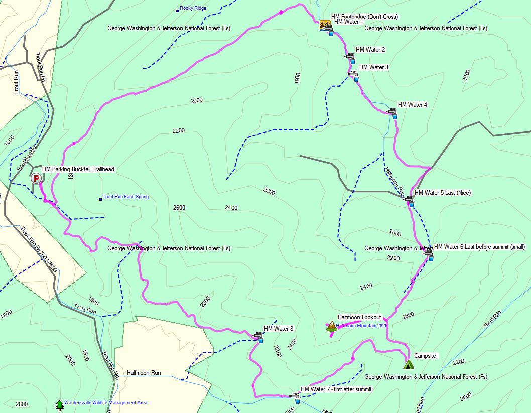
Set out from camp and continue north along the nearby Elk Lake to Dix Mountain Trail.
Get some views of Dix Pond along the way.
At the junction, head right (east) to ascend the Dix via Beckhorn Trail.
Tag Beckhorn (a subsidiary peak of Dix Mountain) for some amazing 360 views of New Yorks Adirondack Mountains.
Continue a short bit and tag the official summit of Dix Mountain for another round of views.
Begin a steep and rocky descent via the Hunters Pass Trail.
Rejoin the Elk Lake to Dix Mountain Trail at the junction from earlier
Return to base camp along the Elk Lake to Dix Mountain Trail.
Dix Range Adirondacks Day 2 Elevation Profile – Sintax77
Day 2 Total Mileage: 7 miles Day 2 Gross Elevation Gain: 2,913 feet Day 2 Gross Elevation Loss: 2,913 feet
Trails Used Day 3 (hike out)
Break camp along the Elk Lake Trail, after the Lillian Brook LT and just before the large bridge crossing Lillian Brook. As of 9/14/17, this site had a yellow “Camp Here” disc, designating it a fully legal spot, despite it’s proximity to a small stream nearby. The stream is probably a convenient water source when flowing good, but we opted to get our water a 100 meters or so down the trail by the Lilian Brook bridge.
Head south on the Elk Lake to Dix Mountain Trail
Pass the Slide Brook Lean-to . The Slide Brook LT and camping area makes for a popular base camp for hikers hitting the Dix Range. We chose to push on a bit (under 2 miles) to the lesser used Lillian Brook lean-to area, which as some nice, legal campsites that are a bit more secluded.
Return to the Elk Lake Trailhead Parking Lot. This is a decent sized lot along a gravel road on the way to the Elk Lake Lodge. If the lot is full, you may park for free at the Elk Lake Lodge, a bit further up the road.
Day 3 Total Mileage: 3.6 miles Day 3 Gross Elevation Gain: 354 feet Day 3 Gross Elevation Loss: 559 feet
Full Trip 3 Day Grand Total Mileage: 14.6 miles Full Trip 3 Day Grand Total Elevation Gain: 3,900 feet
Notable Camping / Backpacking Gear Seen on this Video


 – Freeze Dried Dog Treats for Hiking


 (don’t trust your dog with the cheap key chain grade ones).
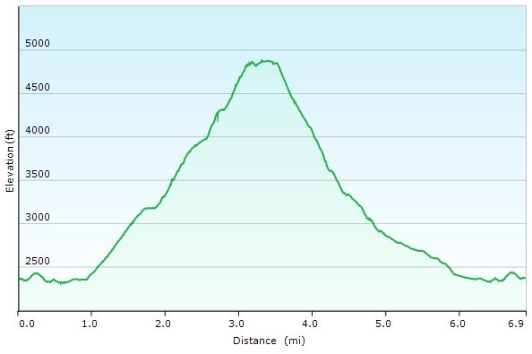
 Bear Canister
 in
in 