Clothing – Make sure to have to ability to cover every square inch of exposed skin. Extreme wind speeds and sub-freezing temps are a recipe for permanent skin damage or even lost fingers and toes (gangrene, frost bite etc). Bring coverage. Bring spares.
Join TJ & I for 3 days of hiking, camping & backpacking in New Hampshire’s Great Gulf Wilderness. Oh, & I also fall on my face.
For this adventure, we’ll be revisiting an attempt at a hike that I originally did as a solo backpacking trip a few years back. A rather aggressive loop, chalking up 30+ miles and over 15,000 feet gross elevation gain, the plan was to give it another go while giving TJ an ultimate sampler platter of the White Mountains. As fate would have it, things would corkscrew towards another outcome…
Full GPS track data and waypoints for various POI’s on this trip are available for download on the Trip Data Page.
Trails Used, Day 1 (in order)
Road hike north on Rt 16 to Dolly Copp Campground
Daniel Webster Scout Trail
Appalachian Trail South
Sphinx Trail
Camp along Sphinx Trail, just before junction with Great Gulf Trail
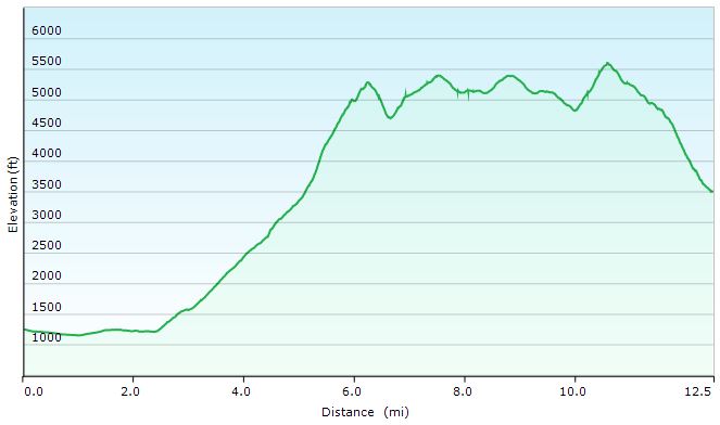
Great Gulf Loop Day 1 Elevation Profile – Sintax77
Day 1 Mileage: 12.5 miles Day 1 Gross Elevation Gain: 6,661′
Trails Used, Day 2 (in order)
Double back on Sphinx Trail
Appalachian Trail South
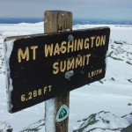
Trinity Heights Connector to Summit of Mt Washington
Have a Chili Dog at the Summit
Nelson Crag Trail
Appalachian Trail South
Great Gulf Trail
Camp near Gulf Trail along ridge
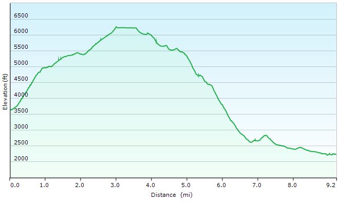
Great Gulf Loop Day 2 Elevation Profile – Sintax77
Day 2 Mileage: 9.2 miles Day 2 Gross Elevation Gain: 3,658′
Trails Used, Day 3 (in order)
Great Gulf Trail
Short road hike back to car parked at Imp Trail Head
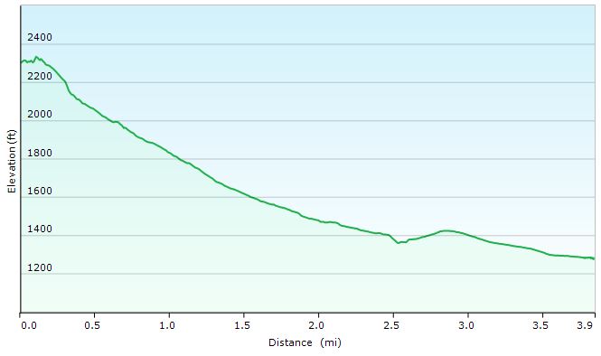
Great Gulf Loop Day 3 Elevation Profile – Sintax77
Day 3 Mileage: 3.9 Day 3 Gross Elevation Gain: 108′
Mileage Grand Total for Trip: 25.6 Gross Elevation Gain Grand Total for Trip: 10,319′
Join Mike, TJ and I for 4 days of hiking & camping as we initiate our friend Zeke on his very first backpacking trip!
For this backpacking trip, we’ll be visiting one of my favorite areas, the White Mountains, for a counterclockwise Pemi Loop. While I’ve previously done this loop as a solo hike, I switched things up this time by doing the loop in the opposite direction, starting with Bondcliff Trail and the Bonds and ending with a traverse of Franconia Ridge to return to the Lincoln Woods Visitor Center where we started. We also stretched the hike out to 4 days and 3 nights. This enabled us to get some more camping and exploring in, and also let us do less miles per day, since this was our friend’s first backpacking experience. The White Mountains are home to some of the most aggressive hiking trails in the country, and our goal was to make sure he actually wanted to do this again!
If you’ve never done a Pemi Loop before and are looking for some more logistics, trail listings, etc, feel free to check out my previous solo video. For this video, we’ll be focusing more the amazing views, camp camaraderie and of course, the biggest question – will Zeke ever want to do this again? Or will he want to push us off one of the numerous precipices that the Pemigewasset Wilderness has to offer…
For info on the “helicopter situation” click here for a link to an August 28th post the Pemigewasset Valley Search and Rescue Team’s Facebook page.
A note on GPS Data: I didn’t record new GPS track data for this trip, as the data from my previous trip pretty much covers the route (in reverse of course) and includes waypoints for points of interest included in that video as well as this one. I also tagged a decent amount of extra potential tent and hammock camping spots as I hiked, which some may find useful if looking for alternative camping spots.
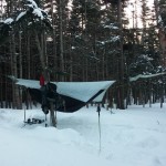
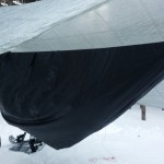
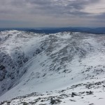
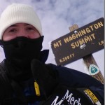
Join me as I attempt a winter ascent of Mt Washington, while hammock camping in the Huntington Ravine.
For this trip, I’ll be heading up to the White Mountains for one more winter backpacking trip before the season ends, and spring arrives. This will also be my first attempt to climb Mt Washington in winter. Okay, climb may be a bit overzealous of a term, but it will be pretty aggressive compared to my other winter hikes. Which brings up an important topic – additional gear needed. I’ll get to that a little later, but first lets take a look at where exactly I started off from and the general route I took. Full GPS track data for this trip can be downloaded on the Trip Data page.
Parking Location: Pinkham Notch Visitor Center near Jackson, New Hampshire.
There were a couple of nice things about parking at Pinkham Notch Visitor Center. First, there was no parking fee, so that’s always nice. They also leave the pack room, bathrooms and changing area open 24 hours, which I was quite happy to discover upon my arrival at 2 AM.
List of Trails Used, in Order
Start at Tuckerman Ravine Trailhead (located right behind visitor center)
Follow the Tuckerman Ravine Trail.
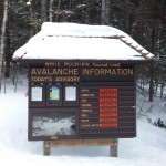
Stop at the Fire Road Junction. Do not continue up Tuckerman Ravine! You should see a sign stating that it is closed in winter due to avalanche danger.
Take Huntington Ravine Fire Road towards Harvard Cabin.
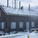
Arrive at Harvard Cabin to setup camp and get organized. The cabin is open from December 1st to April 1st and a caretaker is on site. It is $10 to stay in the cabin, complete with wood burning stove, or $15 to camp in the surrounding area. A big bonus of staying here is the water hole behind the cabin, which is maintained daily. This allows you to get water directly from the stream below, without the chore of melting snow. Registration is done at the Pinkham Notch Pack Room. Click here for more details on the Havard Cabin.
Once setup and geared appropriately, backtrack a bit down the Fire Road.
Before getting back to the junction, take the Lion’s Head Winter Route on your right.
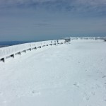
Follow Lion’s Head Winter Route. This is a very steep trail opened as a safer alternative to Tuckerman Ravine Trail during avalanche season. Be prepared to use both hands as well as your ice axe for support. While I did not carry one, a rope could be quite useful and convenient on the way back down.
Rejoin the Tuckerman Ravine Trail (you’re above of the avalanche zone now).
Continue on Tuckerman Ravine Trail, crossing the summer Auto Road and on to the summit.
Follow course in reverse to return to Harvard Cabin to camp for the night.
On day two, hike back out via Huntington Ravine Fire Road and Tuckerman Ravine Trail.
Extra Gear used for my Mt Washington Winter Ascent
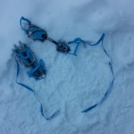
There were two pieces of gear that I brought on this trip, that I’ve never previously felt the need for on other White Mountains winter trips: Crampons and an ice axe.
The ice axe is not to be confused with an ice tool, specialized for actual ice climbing, supported by ropes and typically headed straight up a wall of ice. The ice as, or mountaineering axe as it’s also often called, is longer and straight with a pick for self arresting on one side (this is the primary reason to bring it out on the ice fields of Mt Washington), and an adze on the other side for digging and chopping tasks. The adze is mostly used for more advanced mountaineering techniques than may be required on a Mt Washington attempt, but it does come in handy around camp for setting up a home for the night.
The crampons I chose were universal strap-on crampons, so that I could use them with my regular, flexible winter hiking boots, as opposed to the typical Automatic or semi-auto crampons that require a traditional hard plastic climbing boot, which I do not own. It should also be pointed out that my usual winter traction choice, Kahtoola MICROspikes, are not crampons, nor are they in anyway comparable. I love my micro spikes, but if I had them as my only option on this trip, I probably would have been in some trouble. Or at the very least, it would have taken me twice as long to complete the route.
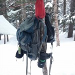
As seen in the video, there are some other pieces of gear that are essential for a Mt Washington winter climb. I should also reiterate that no matter how favorable the forecasted conditions are, you should always pack and carry worst case winter gear. This includes the ability to have all skin fully covered, no exceptions! Conditions can change on a dime in the Whites. Below are some highlights of gear I brought for the above treeline portion of my hike (other gear was left at my base camp below treeline).
EMS Packable Pack (small daypack)
EMS Ascent Mittens with fleece glove liners
Synthetic Ski Hat
Seirus Innovation Neofleece face mask / scarf combo
Bolle Mojo Snow Goggles (Lemon lense color)
Spare hat and gloves (in case others get wet or blown away)
Garmont GTX Snow boots
CAMP Stalker Universal Crampons
Black Diamond Raven Ice Axe
Nalgene 1 Liter wide mouth water bottle
Clothing worn was pretty much exactly what I’ve used on my previous White Mountains snow camping trips. I cover some of the details later in the video as well. You’ll also notice that I do not have snowshoes listed on my above treeline list. I brought a pair of MSR Denali Ascent snowshoes that I left at my base camp, and in fact, that was the only place that they were necessary. I did not find them to be need on the wind blown, ice covered summit cone of Mt Washington – crampons took care of that nicely. The section of Tuckerman Ravine trail approaching Harvard Cabin traversed daily via snowmobile by rangers checking avalanche conditions, so I really didn’t need snowshoes on that portion of the hike as well. A few steps off the trail though, and you’ll quickly find yourself in waist deep snow or more.
Join us for some frigid winter camping and backpacking along King Ravine in the White Mountains.
For this overnight backpacking trip we’ll be heading up towards Mt Adams, along the Presidential Range in New Hampshire’s White Mountain National Forest in early February. This trip was done almost a year to the day after our High Winds Hiking trip during the previous season. Only instead of temperatures in the 20’s to 30’s, we had a dramatically different temperature range the low teens at it’s warmest, down to roughly 20° below zero at night. Ouch. Luckily, we didn’t have the extreme winds that we encountered on that last February trip. One or the other is one thing. Both together, now that’s what you don’t want.
As you’ll see in the video though, things still didn’t go – how should I say – well, as planned. Thankfully, we were able to make the best of it and play things by ear. While I certainly would have like things to have gone a bit closer to our anticipated itinerary, I think it still ended up be a quite memorable trip. When things go as planned, that’s a vacation. When things go awry and you have to react and adapt, that’s an adventure. And that, after all, is what we’re truly after. As long as know one get hurt, or suffers too much mental trauma, I’ll chalk it up as a win.
Below is a list of trails used, in order, as well parking info and other logistical items. Unfortunately, due to the sub-zero temps, there was no full gps track recorded for this trip. After ripping through two sets of Ultimate Lithiums in my Garmin Oregon 650 GPS on day one, I made the call to reserve my remaining rechargeable batteries for emergency route fining only. On my last winter trip to the Dolly Sods, with temps in the low 20’s, I was able to go the entire 3 day trip on one set of lithium with juice to spare. My performance was quite different at 15 or so below zero, though. Once it warms up a bit, we’ll get back to recording full track data as usual.
Parking Location
Appalachia Trailhead
44.371470, -71.289391
(Not too far from the intersection of US Rt 2 and Dolly Copp Rd, in Gorham NH)
Trails Used Airline Trail to
intersection with Upper Bruin Trail, just above treeline in the Alpine Zone
Planned Campsite: Valley Way Tentsite or nearby vicinity, via Valley Way Trail
Actual Campsite: Back below treeline, along the Airline Trail.
Our plan was to summit Mt Adams the following day and return cheerfully to our previous night’s campsite, base camp style. As seen in the video, things got a bit more complicated, due to extreme snow drifting along King Ravine’s Alpine Zone, heading towards Madison Hut and the intersection with the Appalachian Trail towards Mt. Adams. The plan was to save Adams for day two and to use Upper Bruin Trail to head back below treeline to establish a base camp, after getting some brief views in the ravine above treeline. Despite having been to this area twice before in milder weather, the high snow drifts and unbroken trail made navigation, umm, complicated, to say the least. Add Mike’s little ordeal to the mix, and you’ve got yourself a very interesting little winter camping trip. But I’ll let you find out how all that goes in the actual video…
A Quick Overview of some of the Gear Used
Big Agnes 6p tent (yes, is a car camping tent.) Split three ways.
EMS Longtrail 70 Backpack
MSR Denali Ascent Snowshoes
Kahtoolah MICROspikes (the plan was to feel things out while ascending Mt Adams, and turn back if it felt like crampons were more acceptable)
CAMP Snow Shovel
MSR Rapidfire Stove (Inverted canister stove, no longer produced)
*Mike carried an MSR Whisperlight Universal, rigged for white gas, which we ended up using at night due to the colder temps.
Big Agnes Q-Core SL Sleeping Pad
Hammock Gear Burrow 0 Top Quilt
GSI Halulite Tea Kettle, 32 oz, for snow melting
Vargo 450ml titanium cup
Sea to Summit Alpha Light cutlery set (knife, fork, spoon)
Camera Gear Used
Sony Handycam HDR-cx380, primary cam
GoPro Hero 3, Black edition, secondary cam.
RavPower 10,000 mAH usb battery pack recharger
Come along for 4 days of hiking, backpacking and camping in Maine.
For this trip, we’ll be backpacking a loop hike of the Grafton Loop in Maine’s Grafton Notch State Park. Full GPS track data along with points of interest (campsites, water sources, etc) available for download on the Trip Data Page.
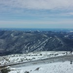
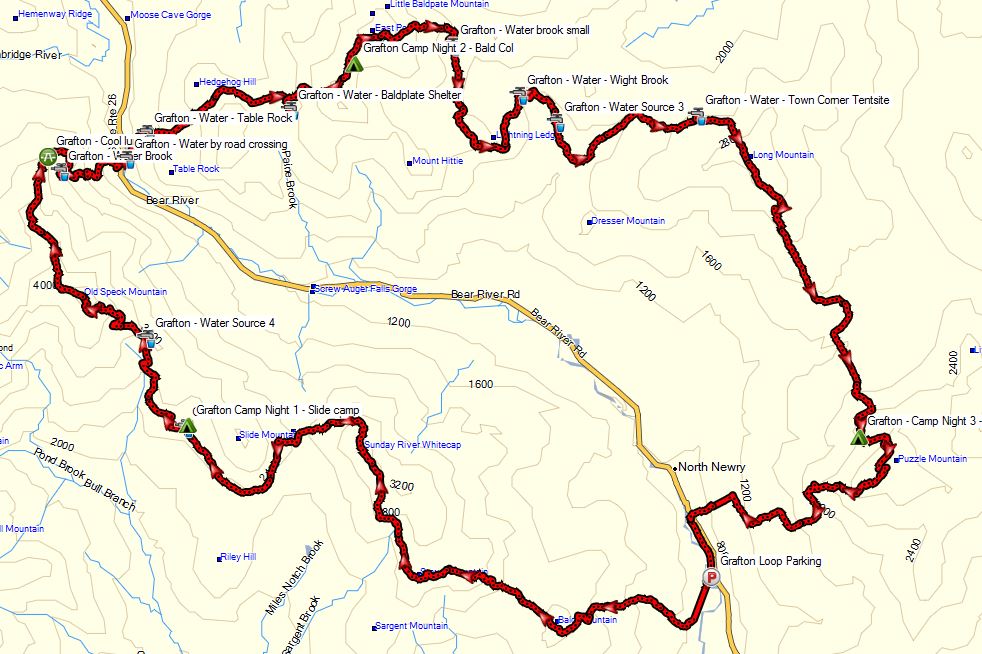
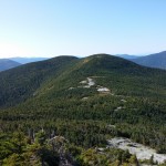
Grafton Loop – Route Overview
The Grafton Loop is a roughly 39 mile, 9 summit hiking loop formed by connecting a portion of the Appalachian trail with the Grafton Loop Trail. Portions of the trail traverse both Maine’s Grafton Notch State Park as well as a good deal of private land. For this reason, designated campsites are mandatory for most of the loop’s route, along with a restriction on campfires. For those of you who like to stealth camp, you’ll have to do a bit more planning for this trip. It took several years to come to an agreement with all of the land owners the that trail traverses, so it’s best to stick to the script and keep them happy so we can continue to enjoy this route.
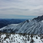
The four of us chose to do the loop clockwise over the course of 4 days. Many people choose to do it in 3 days, and a rarer few do it in 2. Don’t be deceived by the rolling beauty of the photos you see though – the Grafton Loop is still in the White Mountains region and has it’s fair share of strenuous elevation and steep inclines, littered with roots and rocks. If rain is expected, be prepared to move carefully on the many sections of solid and potentially slick rock faces on the balder summits. We stacked up nearly 13,000 feet of elevation gain over the course of our trip. Not too shabby. For comparison, that’s almost 3,000 more feet than the Pemi Loop. Be aware of your group’s capability, as well as desired amount of relaxing versus mileage, and plan your number of days accordingly.
Summits: Bald Mountain, Puzzle Mountain, Long Mountain, Lightning Ledge, Old Speck, West Baldpate, East Baldpate, Miles Notch, Sunday River Whitecap
Parking: 985 Maine 26, Newry, ME 04261 Near intersection of Rt 26 and Eddy Rd
Hike approximately one half mile south from parking lot to the Grafton Loop Trailhead located at 44.530831,-70.825252. Note: Parking is not allowed here at this trailhead, hence the road hike.
Trails Used Day 1: Grafton Loop Trail
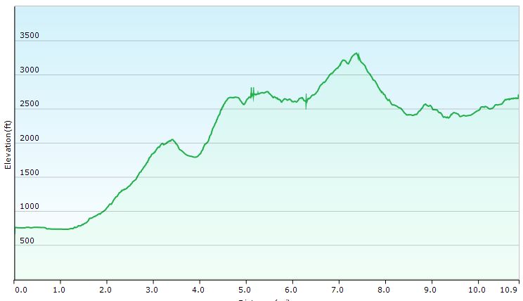
Setup camp at the Slide Mountain Campsite Day 1 Mileage: 10.86 miles Day 1 Gross Elevation Gain: 4,094′
Elevation Profile Day 1
Trails Used Day 2:
Old Speck Trail / Appalachian Trail
Grafton Loop Trail
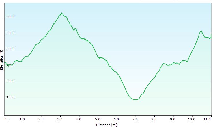
Stealth camp in col between West Baldpate Mountain and East Baldpate Mountain Day 2 Mileage: 11 miles Day 2 Gross Elevation Gain: 4,364′
Elevation Profile Day 2
Trails Used Day 3:
Grafton Loop Trail
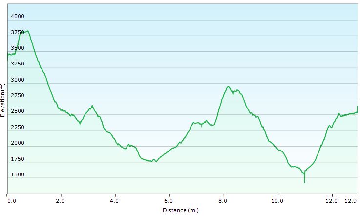
Setup camp at Stewart Campsite Day 3 Mileage: 13 miles Day 3 Gross Elevation Gain: 3,596′
Elevation Profile Day 3
Trails Used Day 4:
Grafton Loop Trail
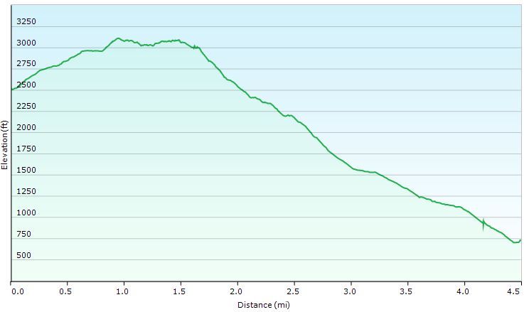
Return to parking lot and Graton Loop Trailhead on Rt 26 Day 4 Mileage: 4.5 miles Day 4 Gross Elevation Gain: 843′
Elevation Profile Day 4
Trip Totals:
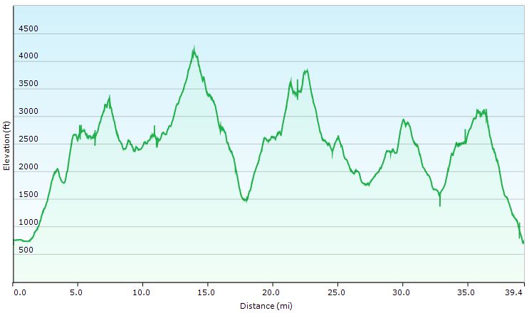
Distance: 39.36 miles
Gross Elevation Gain: 12,807′
Elevation Profile for Entire Route
Our trip began here, at the Grafton Loop’s western trailhead.
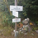
Snowmobile Bridge
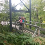
A more laid back Grafton Loop sign.
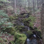
Mossy rocks on our first ascent.
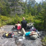
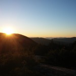
Lunch break on Day 1
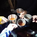
Mike’s Orange Creamsicle cocktails that he made to celebrate the end of Day 1.
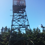
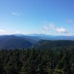
Offers a great view of the Grafton Loop, and far beyond.
View from Fire Tower
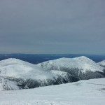
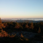
Our view as we ate breakfast on Day 3.
As seen from in between West and East Balpate mountains.
Preparing some breakfast on the Baldpates.
Looking back on West Baldpate
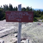
From here we left the AT and rejoined the Grafton Loop Trail.
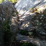
One of two sections on the Grafton Loop that employ the use of iron ladders.
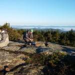
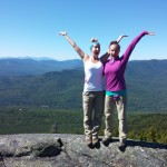
Sara and Danielle always manage to find a spot to kick back…

(Strap-On Crampons)
(Shiny Black, Lemon)
– GPS Emergency Locator Device


Winter Hiking Boots
lightweight traction device


 , 70D model, 12’x10′

 ,
,  .
.