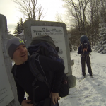
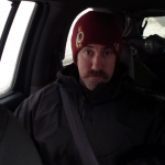
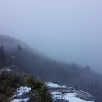
Join us for 2 days of winter camping, backpacking & snowshoeing with a pulk sled in the deep snow of the Adirondack mountains.
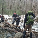
For this winter camping adventure, we’ll be using a DIY pulk sled to setup up a base camp in the Giant Mountain Wilderness. Day one will be dedicated to building camp and settling in, followed by a summit attempt of Giant Mountain on day two.
Our winter pulk sled will be used for group items such as campfire cooking gear, stoves, steaks and other food, additional firewood, our tent, etc. In addition to the sled, Mike, Frank and myself each have a backpack for personal items such as cold weather clothing options and other gear. A list of notable gear can be found at the end of this post.
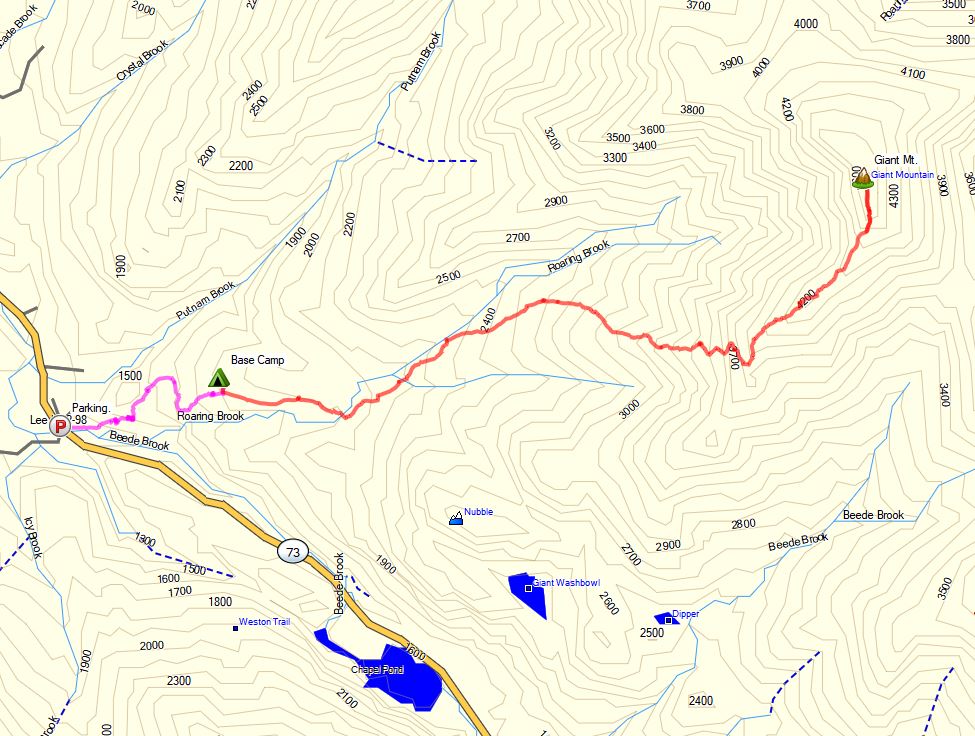
Route Overview – Roaring Brook to Giant Mt – Sintax77
No permit is required to camp in the Giant mountain wilderness, but there are rules and regulations regarding backcountry camping. You can find more information on the Adirondacks Park Giant Mountain Wilderness website here.
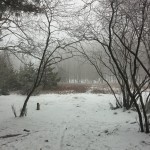
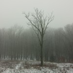
For this Backpacking Trip, we use a Pulk Sled to go Winter Camping in the Deep Snow of the White Mountains.
Mike and I originally planned to do a long overdue return trip to Mt Crawford for some winter backpacking and camping, but as is usually the case, the notorious weather of the White Mountains thwarted our efforts. With a higher summits forecast from the White Mountains Observatory calling for -60° wind chills due subzero temps combined with high winds and gusts upwards of 90 MPH, we opted to stick to the lower elevations instead. So we shelved our higher elevation idea to camp on Mt Crawford, and instead started scouting for a new location on the fly.
Basically, we were winging it in terms of trip planning, but fortunately I was armed with a full set of White Mountains AMC maps to keep up safely prepared on whatever trail we ended up cast upon by the winter hiking gods.
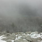
In the video we do some snow campsite selection and setup, tons of firewood collection, snow furniture building, campfire cooking, trail sledding on the rather steep Airline Trail, and overall just plain having a fun time out in the snowy woods of New Hampshire for a few days.
Downloadable GPS data for this trip and others can be found on the Trip Data Page.
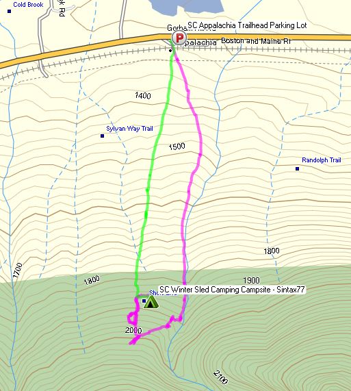
Winter Sled Camping Route Overview – Sintax77
Time of Year Mid February
Parking Location Appalachia Trailhead Parking Lot
44°22’17.6″N 71°17’19.9″W
Trailhead
Appalachia Trailhead on Presidential Hwy (Hwy 2), Randolph, NH
Trails Used, Day One
Valley Way Trail
Randolph Path
Airline Trail
Setup Camp near Airline Trail
Located in the middle of the triangle formed for the Airline, Randolph Path, and Valley Way Trails.We used this campsite with significant snow pack on the ground so leveling out a decent platform for a tent was no problem. Based on my experience in this general area on previous summer trips, I would assume it would not make a very accommodating tentsite without snow, due to the steep and rugged terrain.
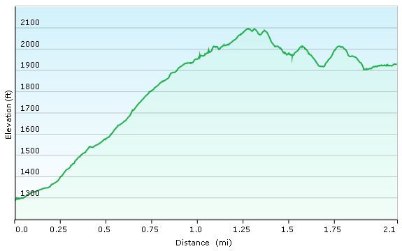
Day 1 Mileage: 2 miles Day 1 Elevation Gain: 1,122′
Winter Sled Camping Day 1 Elevation Profile – Sintax77
Trails Used, Day Two
Airline Trail
Return to vehicle at Appalachia Trailhead Parking Lot
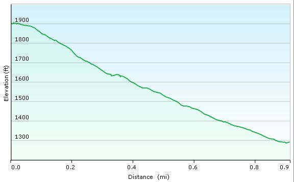
Day 1 Mileage: 1 mile Day 1 Elevation Gain: 6′ (pretty brutal, I know)
Winter Sled Camping Day 2 Elevation Profile – Sintax77
Join Sara, our dog Denali, & I for some Catskills hiking, trail cooking, backpacking, and hammock camping in upstate New York.
For this backpacking trip, we’ll be hiking and camping near Slide Mountain and the East Branch Neversink River in the Catskills, complete with a visit to the summit of Table Mountain and Peekamoose Moose Mountain. The mileage will be low, but the star of this trip isn’t the trails. It’s the food. Good old, classic trail cooking.
What’s on our backpacker’s menu? Well, Sara had a craving for some trail pizza in the middle of the woods somewhere, and I was up for the challenge. Were we successful? You’ll just have to come along and find out. Either way, it’s bound to be an adventure. 😉
Full GPS data for this, as well as all of my other trips, is available on the Trip Data page.
Pheonicia East Branch Trail Peekamoose Table Trail
Set up camp after second bridge (the double log one) at N41° 58.474′ W74° 25.734′
Continue up Peekamoose Table Trail towards summit of
Table Mt and Peekamoose Mountain
Lunch / Snack at summit and Return to camp on the East Branch Neversink River
Day 1 Mileage: 7.8 miles, including summit round trip (about 3 miles each way) Day 1 Gross Elevation Gain: 2,130′
Trails Used Day 2, in Order
Peekamoose Table Trail Pheonicia East Branch Trail Return to vehicle at Denning Rd Trailhead
Day 2 Mileage: 1.8 miles Day 2 Gross Elevation Gain:146′
Trip Total Mileage: 9.6 miles Trip Total Elevation Gain: 2,276
Trail Pizza Ingredients
Boboli Pizza Crust, Individual Size – 2 Pack
Boboli Pizza Sauce Individual Pack (comes in 3 pack box)
Cabot Mozzarella Cheese, Shredded – 8 oz package (2 cups volume)
Hormel Pepperoni, pre-sliced – 6 oz package (enough for 2 pizzas, plus snacking) Camp Cooking Gear Used for Pizza
Join the crew for 3 Days of Winter Camping, Backpacking, & Campfire Cooking in Dolly Sods, West Virginia.
For this adventure we decided to revisit the Dolly Sods Wilderness for some early December winter camping and backpacking. Full GPS track data for this trip is available on the Trip Data page for those who like to follow along at home. Waypoints for campsites and water crossings / sources are included in the GPX file.
List of Trails Used, In order:
Day 1 Park at Red Creek Trailhead, N38° 58.372′ W79° 23.847′ Red Creek Trail TR514
Cross Red Creek at junction with Big Stonecoal Trail Big Stonecoal Trail TR513
Set up Camp at “Tj’s Moustache Camp”
Here’s how to find it: Heading north on Big Stonecoal, pass the intersection with Dunkenbarger trail on your left. Not to far ahead, Big Stonecoal will make an abrupt right turn to make a water crossing across Stonecoal Run. Instead of making the turn, continue straight along the banks, towards the woods. The camp should quickly become apparent.
Water is obviously plentiful. Firewood is probably another story, as this looks to be a popular area in warmer weather. We were equipped with hatchets and saws to process down tress, so all was well. However, during a warm weather trip without tools, I doubt we would have found much smaller stuff just laying around.
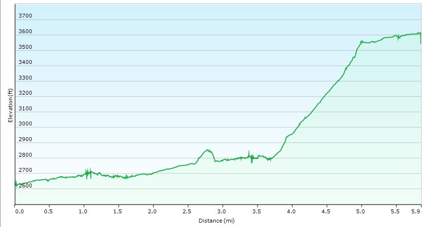
Dolly Sods Winter 2104 Day 1
Day 1 Stat Totals
Mileage: 5.85 Miles
Gross Elevation Gain: 1,444′
Gross Elevation Loss: 453″
Campsite Altitude: 3,613′
Day 2
Backtrack a little bit to previous day’s water crossing.
Continue on Big Stonecoal Trail TR514
Arrive at the junction with Blackbird Knob Trail and Breathed Mountain Trail
Continue on Breathed Mountain Trail TR553
Turn left at junction with Red Creek Trail TR514 ** Shortly after heading out on Red Creek Trail, we found a decent supply of running water on the trail, which was much appreciated, as there would certainly be no water up towards Lion’s Head, where we intended to camp. As it was running in December, I’m thinking this may be a good option in other months as well. No guarantees though. It’s possible this was just snow melt run-off from up above. If all else fails, you could bushwack down to Red Creek, as we had actually planned to do, prior to finding this little gem on the trail. Continue on Red Creek Trail TR514 Bear to the right on Rocky Point Trail TR554
Turn abruptly right at the unofficial spur trail to Lions Head at N38° 59.243′ W79° 22.062′ ** This is not an official trail and will not be found on maps, however, it is marked with a cairn (pile of rocks). Head straight up from the cairn. There is a false summit a little ways in, but you need to actually bear to the left in order to navigate towards Lion’s Head and the eventual campsite. If you go straight towards the false summit, you’ll know it, as there is no where else to go but straight down. No worries, relax, enjoy the view and retreat towards whence you came. You’ll have to hop down some rocks, but the path should be apparent.
Head north on the Unofficial Spur Trail Towards Lion’s Head
Pause to “ooooh and ahhhh” at the sights
Continue north towards camp
Setup Camp on the ridge beyond Lion’s Head
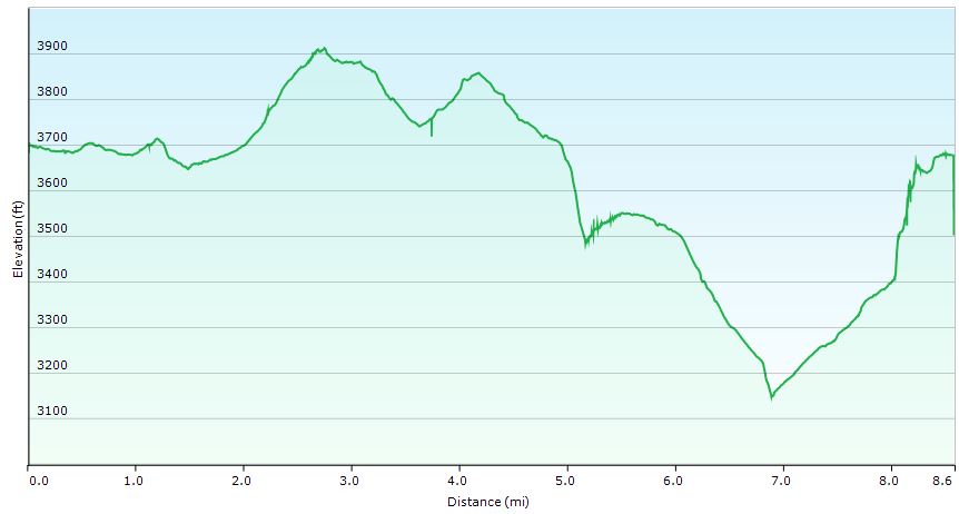
Dolly Sods Winter 2104 Day 2
Day 2 Stat Totals
Mileage: 8.6 Miles
Gross Elevation Gain: 1,083′
Gross Elevation Loss: 1,099′
Campsite Altitude: 3,678′
Day 3 Bushwack Northwest towards Rocky Point Tr
Continue on Rocky Point Tr TR554 Turn left to head south on Big Stonecoal Trail TR514
Take Red Creek Trail TR514 Back towards Parking lot and vehicle
Find a cheeseburger!
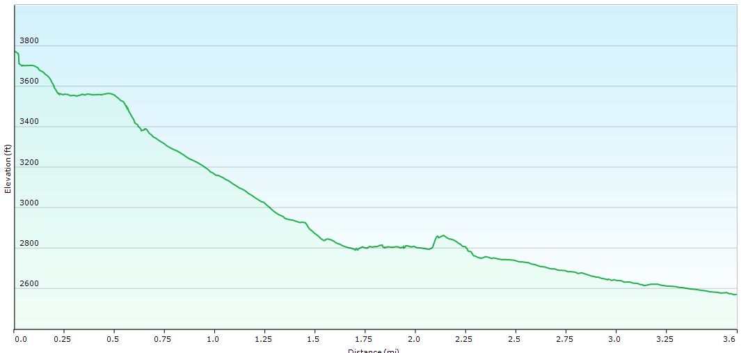
Dolly Sods Winter 2104 Day 3
Day 3 Stat Totals
Mileage: 3.6 Miles
Gross Elevation Gain: 127′
Gross Elevation Loss: 1,332′


 (we were using white gas)

 Tent
Tent (Yellow pad used for bench, I stacked it on top of a
  pad for sleeping at night)
 Sleeping Pad (Mikes sleep pad)
 Backpack (Mike’s pack)
 Snowshoes (my grey snowshoes)
 (Mike’s snowshoes)
 (Fire starter used on day 2)
 listed on Amazon.
 (from dollar store, or whatever)
 – rack used to hold pizza
 (used as a plate / prepping dish / cutting board)