Hammock Camping, Hiking & Ultralight Backpacking on the Quehanna Trail.
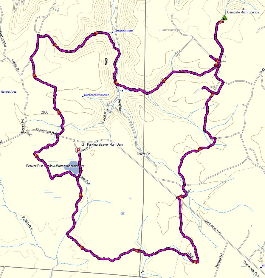
Yes, we’re once again camping in the rain. 🙂 For this overnight backpacking trip, I’ll be hiking a 22 mile loop in Pennsylvania’s Quehanna Wild Area, within the greater Moshannon State Forest. Luckily, I learned from my last camping trip, and packed more adequate rain gear this time.
Itching for another hammock camping trip, I decided to have some fun and go back to more of an ultralight backpacking load-out for this adventure, clocking in at roughly 8.5 pounds base weight.
OV Aerie Underguilt Sleeping Bag Giveaway is still running until November 10th. Enter for free here.
Backpacking water filter membrane sizes.
Roy & Dean sent a great packet of info on hiking and backpacking in Michigan.
Disclosure: A commission may be received for purchases through the links in this post. Your support is appreciated and makes the backpacking trip videos on this channel possible. Be smart, make your own informed decisions, duh. 😉
Disclosure: A commission may be received for purchases through the links in this post. Your support is appreciated and makes the backpacking trip videos on this channel possible. Be smart, make your own informed decisions, duh. 😉
The Optic line of backpacks is aimed at weight conscious and ultralight backpackers. There is a larger Gregory Optic 58 for those with additional space needs as well as a women’s version called the Gregory Octal 45 and Octal 55. All of these packs are very similar, so this review should hopefully be applicable to hikers looking at any of these backpacks.
Join me for 3 days of Hiking, Hammock Camping & Backpacking along the Appalachian Trail in North Carolina’s Nantahala National Forest.
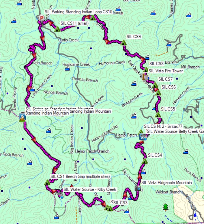
For this backpacking trip, I’ll be doing a 3 day, 2 night hammock camping trip on the Standing Indian Loop in North Carolina’s Nanatahala National Forest. The Standing Indian Loop is a 24 mile loop with a total elevation gain of 4,672′. The loop is made using a portion of the white blazed Appalachian Trail along with the blue blazed Lower Ridge Trail and Long Branch Trail. Campsites and water sources are plentiful on this loop, although many of the campsites are not located along water, so plan accordingly. In my case, I chose two campsites that did have nearby water sources, for added convenience.
Route Overview – Standing Indian Loop – Sintax77
GPS Data for this trip and many others can be found on my Trip Data Page. Includes full track data for each day, and way-points for campsites used / observed along the loop.
Gear Lists for this trip and others can be found on my Gear Lists Page or by using the links below.
Trailhead Used: Standing Indian Campground Information Area – N35° 04.570′ W83° 31.707′ Just up the road from the Standing Indian Campground (car and RV camping), the information area permits overnight parking with spaces available for a half dozen cars or so.
Trails Used, Day 1
Park at the Backcountry Information area, just up the road from Standing Indian Campground. Overnight parking for a half dozen cars or so available at the Info Center, just up the road from the main Standing Indian Campground area. (Overnight parking not available at the actual car camping area)
Lower Ridge Trail (located just behind the bulletin board)
Arrive at intersection with the Appalachian Trail, near summit of Standing Indian Mountain
Setup camp This area has multiple campsite options spread of a large area. A blue blazed spur trail departs the AT near the intersection and leads to a piped spring water source.
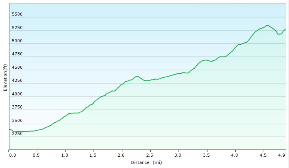
Day 1 Elevation Profile – Standing Indian Loop – Sintax77
Day 1 Mileage: 5 miles Day 1 Gross Elevation Gain: 2,113′
Trails Used, Day 2
Head out Northbound on the Appalachian Trail (away from the spring spur trail) Note: In the video I state on this morning that I was on the Appalachian Trail South. That was incorrect. The AT winds around a bit in this area, and while my compass heading was indeed south, I was actually on the Appalachian Trail North. Arrive at Betty Creek Gap and the depart the Appalachian Trail North on the
Blue Blazed Spur trail to legal camping. While you will notice established campsites directly on the AT at Betty Creek Gap, a sign indicates that camping is currently not permitted in the area for restoration purposes. Setup camp along the water at the end of the blue blazed Betty Creek Gap Spur Trail. There are several campsites of varying size near the water. If they are taken – cross the water and continue about 30 yards to the gravel forest road. After crossing the road, you will immediately see more camping options in the woods beyond the road.
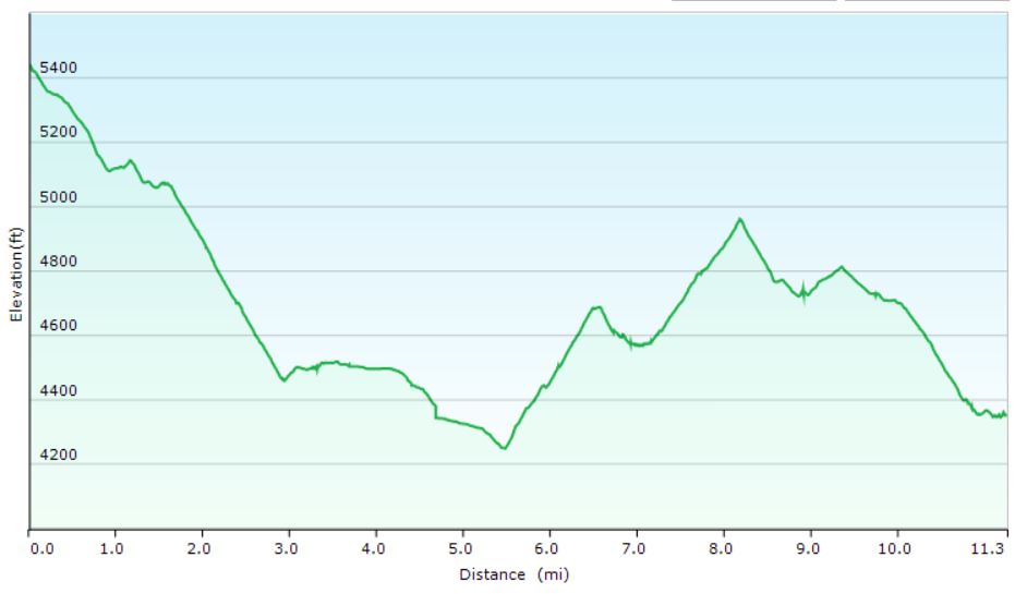
Day 2 Elevation Profile – Standing Indian Loop – Sintax77
Day 2 Mileage: 11 miles Day 2 Gross Elevation Gain: 1,332′
Trails used. Day 3
Backtrack on the blue blazed Betty Creek Spur Trail to the AT intersection from yesterday.
Continue on the Appalachian Trail North.
Catch some views at the Albert Mountain Firetower (located directly on the AT)
Continue on the Appalachian Trail North
At the intersection, take the Long Branch Trail downhill, away from the AT.
Arrive back at the Backcountry Information Area.
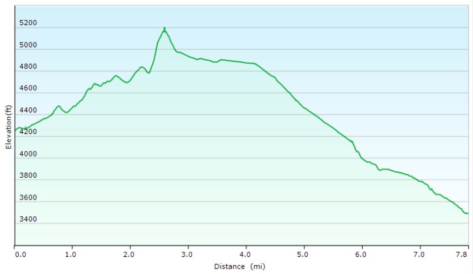
Day 3 Elevation Profile – Standing Indian Loop – Sintax77
Day 3 Mileage: 8 miles Day 3 Gross Elevation Gain: 1,227′

 for Alcohol Stoves (plumber’s pad)
 for those with additional space needs as well as a women’s version called the
  and
and 
 . All of these packs are very similar, so this review should hopefully be applicable to hikers looking at any of these backpacks.