Solo Backpacking the Virginia Triple Crown – Appalachian Trail Section Hike

3 Days of Backpacking, Hiking & Hammock Camping on the Appalachian Trail in Virginia.

For this late summer backpacking trip I’ll be hiking the Virginia Triple Crown, which consists of three iconic Virginia hiking destinations – McAfee Knob, Tinker Cliffs, and Dragon’s Tooth.

To create the loop, I essentially took an Appalachian Trail section hike and combined it with the North Mountain trail to close it off into a 35 mile backpacking loop. This gave me a healthy southern mix of mountain hiking, open pastures, and sweeping summit views.

I went with my most basic warm weather ultralight backpacking gear list for this trip, just to keep things simple and light. Due to the threat of rain, I also included a full set of rain gear. Surprisingly how I was still able to keep my base weight down to around 7.5 lbs. This was mostly achieved by simply leaving non critical items at home. Notable items are below or you can see my full gear list with weights & gear links on LighterPack here.


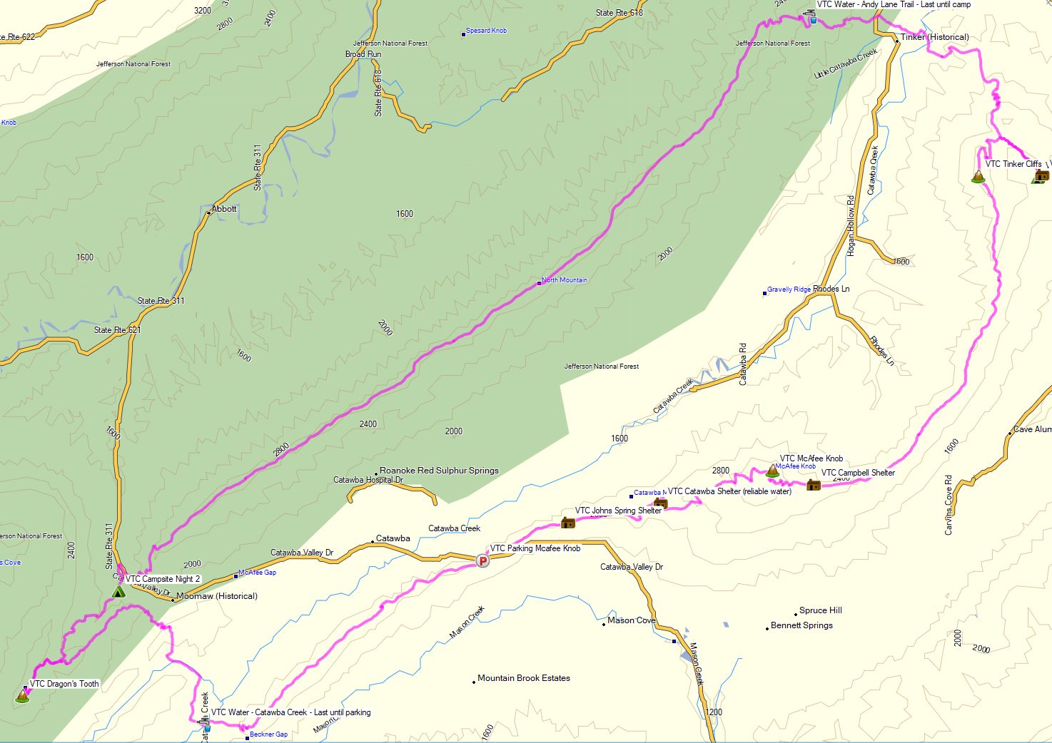
Virginia Triple Crown Route Overview – Sintax77

No permit is required to camp in this area, but there are some camping restrictions along the Appalachian Trail portion of the hike as well as some private land traversals.  You can find more information on the Roanoke Appalachian Trail Club site here.

While on the AT in this area, you may only camp at one of the four designated shelters. Since I was exclusively on the AT for the entire first day, this gave me the following  camping options:

  • Jonh’s Spring Shelter
  • Catawba Shelter (reliable water)
  • Campbell Shelter
  • Lambert’s Meadow Shelter (reliable water)

I chose to camp near Lambert’s Meadow Shelter, as it was the farthest one into the loop and offered reliable water.

Full GPS track data, including campsites, water sources, etc, for this trip and many others can be downloaded on my Trip Data Page.

Continue reading

Lost in Linville Gorge – Hammock Camping in Heavy Rain

3 days of Hammock Camping in the Rain and Solo Ultralight Backpacking in the Linville Gorge Wilderness.

For this backpacking trip, I headed down to North Carolina’s Pisgah National Forest for some hammock camping along the Linville River.  The particular section of river I chose was surrounded by the Linville Gorge, the upper ridges of which stand an average of 1,400 feet above the river banks below.  This terrain, combined with a dense network of  unofficial trails without signage or switchbacks, and often uncrossable river, can make for some rather challenging and exciting hiking.  Add in a forecast of fog and hiking in the rain, and you’ve got yourself a recipe for some true southern outdoors adventure.

Despite the rain, my mid-June temp range for this trip was relatively warm at 70° – 48° or so.  This allowed me to get my backpack’s base weight down to around 9 lbs by leaving my puffy jacket, base layers, warmer hat, gloves etc at home.  I simply packed a long sleeve shirt and a buff and used my rain gear for supplemental warmth at camp.

I went with a fairly minimalist hammock camping setup for this trip.  There are plenty of trees and fun unofficial campsite gems to be found in the Gorge that make ideal for hammocks.   Water is obviously of minimal concern for the lower regions of the gorge.  This allows you to save some weight on trails in those sections, but make sure to stock up when your route heads up towards the ridge.  Especially if you’re looking to camp in one the beautiful ridge side campsites up there.  The extra planning and water weight is well worth the views.

A free permit is required on weekends and holidays from May 1st through October 31st each year. You can find more information on the NFS Grandfather Ranger District website here.

If planning your own trip, I would highly recommend visiting LinvilleGorge.net for maps, info and extensive GPS data including official and unofficial trails, campsites, water sources, etc. Due to the nature of my trip and the fact that their data is so darn good, I didn’t package my own GPS file for this trip, but I did make an overlay map image from their track data that can be downloaded here. Just unzip it and copy the image file to your Garmin’s /Garmin folder if you’re using a Garmin GPS like me, or follow whatever instructions pertain to your particular GPS device. 

Continue reading

A Walk in the Woods – Hammock Camping the Old Loggers Path

Join me for 3 days of Hammock Camping & Ultralight Backpacking on the Old Loggers Path in Pennsylvania’s Loyalsock State Forest.

For this 3 day, 2 night spring backpacking trip, I’ll be hiking a roughly 28 mile backpacking loop along babbling brooks, waterfalls, hardwoods and hemlocks.  Being shoulder season in north central Pennsylvania, my weather ranged from highs in the 70’s down to just below freezing at night, with a little bit of rain sprinkled in for good measure.

Due to the weather, I packed some extra layers and a full set of rain gear.  This increased my pack weight a bit, but I still managed to come in with a base weight of around 10.5 lbs or so.  Water on the Old Loggers Path is fairly plentiful, so I got by with only carrying around 1 liter of water at a time.

Trail conditions on the OLP are a mix of nice flat dirt sections, punctuated by spurts of steep sections littered with Pennsylvania’s infamous rocks to keep you on your toes ; literally.  Despite the occasional rough sections, the average daily gross elevation gain was only around 1,500 feet per day.  I chose to do the loop in a counterclockwise direction, as this allowed me to camp in the Rock Run area after only about 7 miles after my mid-day start on day one.


Old Loggers Path – Route Overview – Sintax77

No permit is required for dispersed camping in the Loyalsock State Forest, so long as you are only camping one night at each campsite.  You can find more information on the Loyalsock State Forest website here.

Full GPS track data, including campsites, water sources, etc, for this trip and many others can be downloaded on my Trip Data Page.

Continue reading

The Madness of Going Outside – Quarantine Backpacking & Cabin Trip

Backpacking on a Section of Pennsylvania’s Blcak Forest Trail.

Mike and I get Covid Cabin Fever and head out for a hammock camping & backpacking trip on a section of Pennsylvania’s Black Forest Trail in Tiadaghton State Forest with some great views of Pine Creek and the “Pennsylvania Grand Canyon”. We also pay a little visit to the cabin on the way back, for some camp chores and relaxation.

FTC Disclosure: This post contains affiliate links, which means I may receive a commission for purchases made through these links.

Trailhead Used
End of Naval Run Road
Slate Run, PA 17769
41°27’29.7″N 77°30’57.5″W

Notable Backpacking Gear (used by Sintax77)


MEGA Tarp for 2 Hammocks or Bad Weather – Dutchware Xenon

Setting up my Dutchware Xenon Two Person Tarp for Two Hammocks under One Tarp or Bad Weather Camping Conditions, such as wind snow and rain while hammock camping.

This is a 12 foot long, 11.5 foot wide tarp with an end pole mod to better accommodate a two hammock spreader bar setup and two doors at one end for wind protection, privacy at camp, etc.

I’m also using an optional internal pole mode to create even more space inside.  I’m using a single one in the middle, but it’s also possible to use two of them for even more space.  If you want to take it even further, you can have it made with optional side pull-outs as well.  I don’t really find this necessary with the internal pole mods that I’m using. I suppose you could go that route if you’re looking for a lighter alternative to the internal pole mod.

The double hammock spreader bar system I’m using is a Dutchware Beetle Buckle suspension with 32″ spreader bar pole, but I don’t see why you couldn’t use this tarp with any other DIY spreader bar solution you may already be using.

Continue reading

Winter Hammock Camping – Amok Draumr XL – Snow on Unknown Pond

3 Days of Winter Hammock Camping, Backpacking, & Snow Hiking in New Hampshire’s White Mountains using the Amok Draumr XL Hammock.

For this 3 day, 2 night spring snow camping trip, I’ll be hiking a section of trail in northern New Hampshire to setup a winter base camp in the remote Mt Cabot & Unknown Pond region of the White Mountain National Forest.

For sleep and shelter I packed in my Amok Draumr XL hammock, paired with the Amok Borg tarp and Amok Fjol XL sleeping pad.  I had never used the Amok hammock on a winter trip before, so I figured this would be a good opportunity to test it, as the forecast called for a decent amount of snow and temperatures a little bit below it’s recommended temperature range of 20°F.  More details on my winter backpacking gear can be found at the end of this post.

Unknown Pond Route Overview – Sintax77

No permit is required to camp in the White Mountains NF, but there are rules and regulations regarding backcountry camping. You can find more information on the USFS White Mountains website here.

Full GPS track data, including campsites, water sources, etc, for this trip and many others can be downloaded on my Trip Data Page.

Continue reading